
Plouyé
|
Plouyé Plouie |
||
|---|---|---|
|
||
| region | Brittany | |
| Department | Finistère | |
| Arrondissement | Chateaulin | |
| Canton | Carhaix-Plouguer | |
| Community association | Monts d'Arrée Communauté | |
| Coordinates | 48 ° 19 ′ N , 3 ° 44 ′ W | |
| height | 67-246 m | |
| surface | 37.55 km 2 | |
| Residents | 674 (January 1, 2017) | |
| Population density | 18 inhabitants / km 2 | |
| Post Code | 29690 | |
| INSEE code | 29211 | |
 Saint-Pierre church |
||

Plouyé ( Breton Plouie ) is a French commune in Brittany in the Finistère department with 674 inhabitants (as of January 1, 2017). The place name is translated for "community of Ia" and could be related to the Cornish saint Ia .
geography
The place is near the Regional Nature Park Armorique ( French Parc naturel régional d'Armorique ), in a hilly and wooded area. The Ellez River runs along the southwestern municipal boundary .
Morlaix is 30 kilometers north, Brest 55 kilometers west, Rennes 150 kilometers east-southeast and Paris around 450 kilometers east.
traffic
Plouyé is remote from the main traffic routes. At Morlaix and Landivisiau the next exits are on the expressway E 50 ( Rennes -Brest) and regional train stations on the parallel railway line.
The nearest regional airports are at Brest and Rennes .
Population development
| year | 1962 | 1968 | 1975 | 1982 | 1990 | 1999 | 2008 | 2017 |
| Residents | 1241 | 1048 | 958 | 836 | 726 | 675 | 724 | 674 |
| Sources: Cassini and INSEE | ||||||||
Attractions
- Parish Church of Saint-Pierre
- Saint-Mathurin Chapel
- Saint-Maudez chapel
- Saint-Salomon Chapel
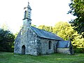
Saint-Mathurin Chapel

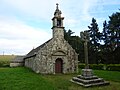
Saint-Maudez chapel
Saint-Salomon Chapel


literature
- Le Patrimoine des Communes du Finistère. Flohic Editions, Volume 1, Paris 1998, ISBN 2-84234-039-6 , pp. 580-582.
Web links
Individual evidence
- ^ Cf. Nicholas Orme: The Saints of Cornwall . Oxford University Press 2000, ISBN 0-19-820765-4 , p. 145.