Botmeur
|
Botmeur Boneur |
||
|---|---|---|

|
|
|
| region | Brittany | |
| Department | Finistère | |
| Arrondissement | Chateaulin | |
| Canton | Carhaix-Plouguer | |
| Community association | Monts d'Arrée Communauté | |
| Coordinates | 48 ° 23 ′ N , 3 ° 55 ′ W | |
| height | 225-382 m | |
| surface | 13.62 km 2 | |
| Residents | 215 (January 1, 2017) | |
| Population density | 16 inhabitants / km 2 | |
| Post Code | 29690 | |
| INSEE code | 29013 | |
 Mairie Botmeur |
||
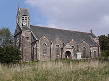
Botmeur ( Breton Boneur ) is a French commune in Brittany in the Finistère department with 215 inhabitants (as of January 1, 2017).
location
The place is in the Regional Nature Park Armorique ( French Parc naturel régional d'Armorique ), on the southern edge of the mountain range "Monts d'Arrée" in a hilly and wooded, but only sparsely populated area.
Morlaix is 22 kilometers north, Brest 40 kilometers west, Rennes 165 kilometers east-southeast and Paris about 460 kilometers east.
Population development
| year | 1962 | 1968 | 1975 | 1982 | 1990 | 1999 | 2009 | 2017 |
| Residents | 333 | 277 | 236 | 196 | 191 | 214 | 228 | 215 |
| Sources: Cassini and INSEE | ||||||||
traffic
The municipality of Botmeur is remote from the main traffic routes. At Morlaix and Landivisiau the next exits are on the expressway E 50 ( Rennes -Brest) and regional train stations on the parallel railway line.
literature
- Le Patrimoine des Communes du Finistère. Flohic Editions, Volume 1, Paris 1998, ISBN 2-84234-039-6 , pp. 564-567.
Web links
Commons : Botmeur - collection of images, videos and audio files

