
Scrignac
| Scrignac | ||
|---|---|---|
|
||
| region | Brittany | |
| Department | Finistère | |
| Arrondissement | Chateaulin | |
| Canton | Carhaix-Plouguer | |
| Community association | Monts d'Arrée Communauté | |
| Coordinates | 48 ° 26 ′ N , 3 ° 41 ′ W | |
| height | 86-281 m | |
| surface | 70.94 km 2 | |
| Residents | 757 (January 1, 2017) | |
| Population density | 11 inhabitants / km 2 | |
| Post Code | 29640 | |
| INSEE code | 29275 | |
 Mairie Scrignac |
||

Scrignac ( Breton Skrigneg ) is a French commune in Brittany in Finistere region, with 757 inhabitants (at January 1, 2017).
location
The place is in the Regional Nature Park Armorique ( French Parc naturel régional d'Armorique ), at the foothills of the ridge "Monts d'Arrée" in a hilly and wooded area.
Morlaix is 20 kilometers to the north, Brest 60 kilometers to the west, Rennes 150 kilometers to the east-southeast and Paris about 450 kilometers to the east (all figures slightly rounded as the crow flies ).
traffic
Scrignac is remote from the main traffic routes. At Morlaix and Landivisiau the next exits are on the expressway E 50 ( Rennes -Brest) and regional train stations on the parallel railway line.
The nearest regional airports are at Brest and Rennes .
Population development
| year | 1962 | 1968 | 1975 | 1982 | 1990 | 1999 | 2008 | 2017 |
| Residents | 1946 | 1687 | 1405 | 1222 | 1005 | 883 | 809 | 757 |
| Sources: Cassini and INSEE | ||||||||
Attractions
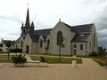
Notre-Dame church

Saint-Corentin chapel in the Trénivel district

Former Berrien-Scrignac train station


See also: List of Monuments historiques in Scrignac
literature
- Le Patrimoine des Communes du Finistère. Flohic Editions, Volume 1, Paris 1998, ISBN 2-84234-039-6 , pp. 582-585.