Castrillón (Boal)
| Municipality of Boal: Parroquia Castrillón | ||
|---|---|---|
| coat of arms | Map of Spain | |

|
|
|
| Basic data | ||
| Autonomous Community : |
|
|
| Comarca : | Eo-Navia | |
| Coordinates | 43 ° 24 ′ N , 6 ° 48 ′ W | |
| Height : | 211 msnm | |
| Area : | 20.04 km² | |
| Residents : | 195 (January 1, 2011) INE | |
| Population density : | 9.73 inhabitants / km² | |
| Postal code : | 33727 | |
| Area code: | 33007020000 | |
| Nearest airport : | Asturias Airport 102 km | |
| administration | ||
| Address of the municipal administration: | Plaza del Ayuntamiento, s / n 33720 BOAL | |
| Website : | www.concejodeboal.net | |
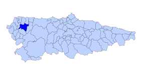
| Location of the municipality | ||

|
||
Castrillón ( Asturian Castriyón ) is a parroquia and a place in the municipality of Boal of the Autonomous Community of Asturias in northern Spain .
The 195 inhabitants (2011) live on an area of 20.04 km², 11 km from the municipal capital Boal on the right bank of the Rio Navia .
The first traces of settlement come from the Celts , which is proven by numerous sites in the community. The settlement lasted constant over the Castro culture and the Roman occupation .
The castle (Castro) on the mountain slopes above the Rio Navia is the namesake of the community. The castle itself was used as a quarry in 1897, so only remains of the foundations can be seen.
Attractions
- Parish Church of San Pedro
Villages and hamlets
Web links
- Information page in the tourism portal vivirasturias in English and Spanish
- Map of Asturias (PDF; 12.52 MB)
