Cerros Colorados
| Portezuelo Grande structure | |||||||
|---|---|---|---|---|---|---|---|
| Location sketch | |||||||
|
|||||||
|
|
|||||||
| Coordinates | 38 ° 30 ′ 0 ″ S , 68 ° 50 ′ 0 ″ W | ||||||
| Data on the structure | |||||||
| Construction time: | ... - 1978 | ||||||
| Height of the barrier structure : | 12 m | ||||||
| Building volume: | 0.5 million m³ | ||||||
| Crown length: | 3250 m | ||||||
| Loma de la Lata building | |||
|---|---|---|---|
|
|
|||
|
|
|||
| Coordinates | 38 ° 32 '43 " S , 68 ° 36' 38" W. | ||
| Data on the structure | |||
| Construction time: | ... - 1977 | ||
| Height of the barrier structure : | 16 m | ||
| Building volume: | 1.5 million m³ | ||
| Crown length: | 1500 m | ||
| Planicie Banderita structure | |||
|---|---|---|---|
|
|
|||
|
|
|||
| Coordinates | 38 ° 33 ′ 39 ″ S , 68 ° 28 ′ 29 ″ W. | ||
| Data on the structure | |||
| Construction time: | ... - 1978 | ||
| Height of the barrier structure : | 34 m | ||
| Height of the structure crown: | 417.50 m | ||
| Building volume: | 0.4 million m³ | ||
| Crown length: | 350 m | ||
| Power plant output: | 479 or 486 MW | ||
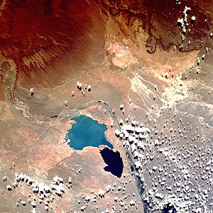
| Cerros-Colorados complex, photographed from the space shuttle. Los Barreales is up and light blue; Mari Menuco is the smaller and darker one. The river flows from the top left to the bottom right. | |||
Cerros Colorados is a complex of dams and hydropower plants on the Lower Neuquén River in the Argentine province of Neuquén in the Comahue region in northwestern Patagonia . Cerros Colorados is itself part of a larger network of dams known as the El Chocón-Cerros-Colorados Complex, which also includes the El Chocón dam and its waterworks. These are further up the Limay River .
overview
Cerros Colorados consists of four barriers (Portezuelo Grande, Loma de la Lata, Planicie Banderita and El Chañar) and uses two deep natural depressions called "Los Barreales" and "Mari Menuco". These two together are the reservoirs of Cerros Colorados; they lie next to the natural course of the Neuquén.
The Neuquén is first dammed with the Portezuelo Grande lock . The water is diverted to Los Barreales Lake. From this, water can be taken for irrigation as well as for drinking and service water supply. The water flows through the "Loma de la Lata" dam to the "Mari Menuco" reservoir. The water level in the Mari Menuco reservoir is 69 m higher at its outlet at "Planicie Banderita" than the river that the water reaches there again. This difference in height is used in the Planicie-Banderita hydropower plant to generate electricity. This has two vertical Francis turbines with Siemens generators with a capacity of 243 MW each (other figures are also given) and generates 1512 GWh of electricity annually, which is fed into the national electricity grid via 500 kV lines.
Another small dam called "El Chañar" is located about 10 km below Planicie Banderita in order to regulate the Neuquén there again.
Construction work began in 1969. The first turbine was put into operation in 1978. On October 31, 1980, the complex was officially put into operation. In 1993 it was privatized and given the concession to the company Hidroeléctrica Cerros Colorados SA. In 2000, Cerros Colorados was acquired by Duke Energy together with the Alto Valle thermal power station .
Dates of the Los Barreales reservoir
- The lake surface is 421 meters above sea level.
- The water level can fluctuate by 7 m.
- The surface is 413.1 square kilometers (about 70 percent of Lake Geneva )
- The mean depth is 67 m.
- The maximum depth is 120 m.
- The stored water volume is 27.7 billion m³ (according to other sources 25.1 or 28.1 billion m³).
- The shore is 214.5 km long.
- The average retention time of the water is 2.4 years.
- The catchment area of the Río Neuquén at the Portezuelo Grande dam is about 20,000 km².
- The Río Neuquén has an average discharge of 360 m³ / s here.
According to various sources, both reservoirs together should have a storage space of 43 or even 48 billion m³. - The barriers are dams, some combined with gravity dams .
See also
- List of the largest dams on earth
- List of the largest reservoirs on earth
- List of the largest hydroelectric plants in the world
- List of power plants in Argentina
- List of dams in the world (Argentina)
Web links
- Duke Energy Argentina Generación , Complejo Cerros Colorados
- Argentour Río Limay
- Secretaría de Energía, República Argentina Complejo Cerros Colorados .
- Hidroeléctrica Cerros Colorados SA
Individual evidence
- ↑ Archive link ( Memento of the original from September 27, 2007 in the Internet Archive ) Info: The archive link was inserted automatically and has not yet been checked. Please check the original and archive link according to the instructions and then remove this notice.
- ↑ http://www.oni.escuelas.edu.ar/2001/neuquen/poderdelrio/Nqn%20Presa%20Portezuelo.htm
- ↑ http://www.intertournet.com.ar/agua/loma.htm
- ↑ Archive link ( Memento of the original from July 27, 2006 in the Internet Archive ) Info: The archive link was inserted automatically and has not yet been checked. Please check the original and archive link according to the instructions and then remove this notice.

![Building Portezuelo Grande [1] [2] (Neuquén)](https://upload.wikimedia.org/wikipedia/commons/thumb/d/df/Argentina_Neuqu%C3%A9n_location_map.svg/300px-Argentina_Neuqu%C3%A9n_location_map.svg.png)
