
Chōkai Quasi-National Park
|
Chōkai Quasi-National Park
|
||
_-_Flickr.jpg) The twin volcano Chōkai (2,236 m) |
||
| location | Akita / Yamagata Prefecture , Honshū , Japan | |
| surface | 289.55 km² | |
| WDPA ID | 1963 | |
| Geographical location | 38 ° 6 ' N , 140 ° 3' E | |
|
||
| Sea level | from 0 m to 2236 m | |
| Setup date | July 24, 1963 | |
| administration | Akita Prefecture , Yamagata Prefecture | |

The Chōkai Quasi National Park ( Japanese 鳥 海 国 定 公園 , Chōkai Kokutei Kōen ) is a quasi national park in Japan . The park, which was founded on July 24, 1963, extends over a total area of approx. 290 km² in the prefectures Akita and Yamagata , which are responsible for the management of the park. The area is divided into three areas:
- Main area: Area around the eponymous twin volcano Chōkai
- Tobishima Island (Yamagata)
- Kisakata ( 象 潟 )
With the IUCN Category V, the park area is classified as a Protected Landscape / Protected Marine Area . Akita and Yamagata prefectures are responsible for managing the park.
gallery
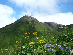
Chōkai seen from the west

Path to Chōkai volcanic mountain
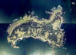
Tobishima Island ( Japanese j 曽 の 白 滝 , Tobi shima )

Nasonoshira waterfall ( Japanese 飛 島 , Naso no shirataki )
_(2).jpg)


.jpg)

See also
Web links
Commons : Chōkai Quasi-National Park - Collection of images, videos and audio files