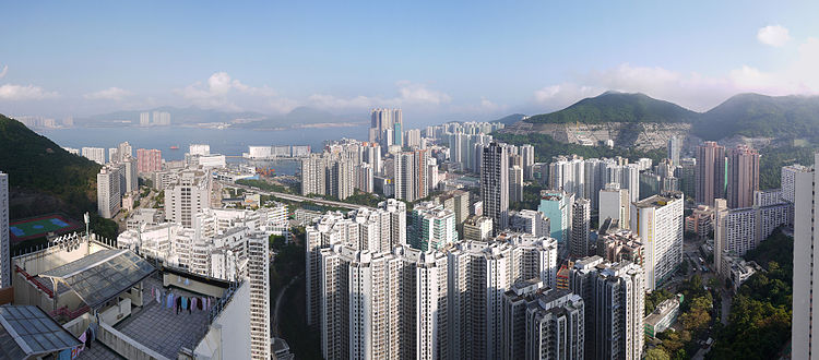
Chai Wan (Hong Kong)
Chai Wan ( Chinese 柴灣 / 柴湾 , Pinyin Chái Wān , Jyutping Caai 4 Waan 1 - "Firewood Bay ") is a district of Hong Kong in the northeast of Hong Kong Island . An earlier place name is "Sai Wan" ( 西 灣 / 西 湾 , Xī Wān , Jyutping Sai 1 Waan 1 - "western bay"), for example in the name "Sai Wan War Cemetery" ( 西 灣 戰爭 墳場 / 西 湾战争 坟场 , Xī Wān Zhànzhēng Fénchǎng , Jyutping Sai 1 Waan 1 Zin 3 zang 1 Fan 4 coeng 4 ) was preserved. In contrast, the place name of Cantonese origin Sai Wan ( cant.西 環 / 西 环Pinyin Xī Huán Jyutping Sai1 Waan4, western district ), also known as Western District ( 西區 / 西区 , Xī Qū , Jyutping Sai 1 Keoi 1 - "western district") ), for the western part of the city of Sheung Wan and the western part of the Central and Western District .
Chai Wan is part of the Eastern District . The place is between Shau Kei Wan in the west and Cape Collinson in the east. Depending on the context, the districts of Heng Fa Chuen ( 杏花邨 - "Apricot Blossom Village ") and Siu Sai Wan ( 小 西 灣 / 小 西 湾 - "Little West Bay") can be meant as part of Chai Wan or as separate districts. A total of around 180,000 people live in the area.
The Island Line of the Mass Transit Railway stops in Heng Fa Chuen and ends in central Chai Wan. The Route 4 highway also leads to Chai Wan via Heng Fa Chuen . The Tai Tam Road leading to the Southern District of Stanley and Shek O .
history
Chai Wan has been inhabited since the time of the Qianlong Emperor in the Qing Dynasty . Until the 1940s, the population consisted mainly of the original six villages of the Hakkas Law Uk ( 羅 屋 / 罗 屋 , Luó Wū , Jyutping Lo 4 Uk 1 ), Shing Uk , ( 成 屋 , Chéng Wū , Jyutping Sing 4 Uk 1 ), Lam Uk ( 藍 屋 / 蓝 屋 , Lán Wū , Jyutping Laam 4 Uk 1 ), Luk Uk ( 陸 屋 / 陆 屋 , Lù Wū , Jyutping Luk 6 Uk 1 ), Sai Tsuen ( 西村 , Xī Cūn , Jyutping Sai 1 Cyun 1 ) and Tai Peng Tsuen ( 大 坪村 , Dàpíng Cūn , Jyutping Daai 6 ping 4 Cyun 1 ). A traditional Hakka family village house from the 18th century has been preserved as the Law Uk Folk Museum . In the second half of the 20th century there were large urban development projects for the construction of residential and industrial buildings. The bay was filled in for the purpose of reclaiming land , only a cargo port surrounded by industrial plants remained. Two milestones in this development are the completion of the two MTR stations and the Island Eastern Corridor of Route 4 .
panorama
Heng Fa Chuen
Heng Fa Chuen ( 杏花邨 , Xìnghuā Cūn , Jyutping Hang 4 faa 1 Cyun 1 - "village of apricot blossoms ") is a residential area in the north of Chai Wan, which was built in the 1980s. Around 20,000 people live in 50 high-rise buildings.
Siu Sai Wan
Siu Sai Wan ( 小 西 灣 / 小 西 湾 , Xiǎo Xī Wān , Jyutping Siu 2 Sai 1 Waan 1 - "small west bay") is a residential area in the east of Chai Wan. One of the largest residential buildings is the 60-story, 200-meter-high Island Resort . The Siu Sai Wan Sports Ground football stadium is located in Siu Sai Wan . South of Siu Sai Wan is the Cape Collinson Correctional Institution .
From 1951 the Royal Air Force (RAF) operated the Little Sai Wan base in Siu Sai Wan to eavesdrop on radio communications from the People's Republic of China . In 1964 the RAF handed over the facility to the Government Communications Headquarters , which continued operations together with the Australian Defense Signals Directorate . The plant moved to a new location in Chung Hom Kok in 1982 . The buildings in Siu Sai Wan continued to be used by the British government for other purposes until they were demolished in 1988 to be used for housing.
Web links
Individual evidence
- ↑ Jason Wordie: Streets: Exploring Hong Kong Island . Hong Kong University Press, Aberdeen, Hong Kong 2002, ISBN 962-209-563-1 , pp. 190-192 .
- ↑ a b 2011 Population Census - Fact Sheet for Eastern District Council District . Constituencies C07 to C13 and C33 to C37 ( map ; PDF; 2.3 MB). Retrieved June 9, 2013.
- ↑ Rosanna Pui-Yan Eng: Siu Sai Wan: Life On And By Water . The University of Hong Kong, Pok Fu Lam, Hong Kong 1999, pp. 8 , doi : 10.5353 / th_b3198071 .
- ↑ Ex-RAF Aerial Erectors Association: Past Places. RAF Little Sai Wan. No 367 Signals Unit. Retrieved March 29, 2014.
- ^ A b The 367 Association: 367 Signals Unit - History . Retrieved March 29, 2014.
- ↑ Richard Aldrich: Little Sai Wan passes from RAF control to GCHQ , June 16, 2010. Retrieved March 29, 2014.
- ↑ Desmond Ball: Signals Intelligence in the Post-Cold War Era. Developments in the Asia-Pacific Region. Page 67. ISBN 981-3016-36-1 and ISBN 981-3016-37-X . Preview on Google Books .
Coordinates: 22 ° 16 ' N , 114 ° 14' E


