Southern District (Hong Kong)
|
南 區 Southern District
Southern |
|
|---|---|
 Location of the Southern District in Hong Kong |
|
| Basic data | |
| Country | People's Republic of China |
| Special Administrative Region | Hong Kong |
| surface | 38.9 km² |
| Residents | 274,994 (2016) |
| density | 7078 inhabitants per km² |
| founding | 1981 |
| ISO 3166-2 | HK |
| Website | Southern District Council (en, zh) |
| politics | |
| Chairman | CHU, Ching-hong (as of 2019) 朱慶虹 |
| Political party | independent |
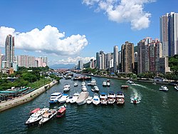
| Southern Districts Downtown on Aberdeen Harbor , 2016 | |
Coordinates: 22 ° 14 '50 " N , 114 ° 9' 32" E


Southern District ( Chinese 南 區 / 南 区 , Pinyin Nán Qū , Jyutping Naam 4 Keoi 1 ) is a district in Hong Kong in the southern part of Hong Kong Island . Of the four districts on Hong Kong Island, Southern has the largest area and lowest population density with 39.40 km². The 2011 census determined a population of 278,655.
Some nearby islands are also part of the Southern District. The largest, Ap Lei Chau , is connected to Hong Kong Island via the four-lane Ap Lei Chau Bridge , an originally two-lane car bridge from the 1980s. More distant offshore islands in the south of Hong Kong Island belong to the Islands District .
In the west and southwest of the Southern District there are larger residential areas with Pok Fu Lam , Aberdeen and Ap Lei Chau . Ocean Park amusement park is located near Aberdeen. The east of the Southern District is less urban. In addition to village structures and nature reserves , facilities and institutes of the University of Hong Kong are also located here . The fishing village of Shek O in the southeast of the island, east of Stanley , for example, is a protected landscape area and popular local recreation area. Southern has beautiful beaches and hiking trails, such as Deep Water Bay , Repulse Bay, and Stanley Bay . Most of the 50 km long popular Hong Kong Trail ( 港島 徑 / 港岛 径 ), a hiking trail from Victoria Peak to Big Wave Bay , as well as the Cape D'Aguilar lighthouse, the oldest lighthouse in Hong Kong, are located in Southern.
traffic
The Route 1 performs the Aberdeen tunnel for Wan Chai District and connects the Southern District with the expressway network of Hong Kong. The eastern section of the South Island Line of the Mass Transit Railways in the Southern District has been open since December 28, 2016 and connects the offshore southern island of Ap Lei Chau via Wong Chuk Hang, Ocean Park with the busy district of Admiralty in the north of Hong Kong Island, while the west section of the South Island Line is still in the planning phase and the construction phase is expected to begin in 2021 and will need another five years to complete in 2026. Most places in the district are accessible via bus lines or lines of the so-called " minibuses " ( 公共 小型 巴士 , English Public Light Bus - " shared taxis ", coll. 小巴 ).
places
On Hong Kong Island:
- Aberdeen
- Cape D'Aguilar
- Chung Hom Kok
- Deep Water Bay
- Pok Lam Fu
- Repulse Bay
- Shek O
- Stanley
- Tai Tam
- Wah Fu
- Wong Chuk Hang
Islands:
- Ap Lei Chau
- Ap Lei Pai
- Kau Pei Chau
- Lo Chau
- Lung Shan Pai
- Magazine Island
- Middle Island
- Ng Fan Chau
- Round Island
- Tai Tau Chau
- Tau Chau
See also
Web links
- Southern District Information - District Highlights - HK District Councils (Chinese, English)
- Southern District - Hong Kong Fun in 18 Districts - HK Home Affairs Department (Chinese, English)
- Hong Kong Electoral Affairs Commission:
Official Map 01 - Southern District - Wahlkreis- u. District boundaries (PDF, 2.1 MB, Chinese, English)
Official Map 02 - Southern District - constituency u. District boundaries (PDF; 1.6 MB, Chinese, English) - Southern District Tourism (Chinese, English)
- Discover Hong Kong - Southern District (Chinese, German)
Individual evidence
- ↑ Citypopulation: [1] on citypopulation.de, accessed on August 25, 2017 - online
- ↑ Census and Statistics Department: 2016 Population Census - Key Statistics (PDF file; 396KB) at statistics.gov.hk, accessed on October 25, 2017 - Online
- ↑ Politiker-Info 01 (Chinese): [2] , on neodemocrats.hk, accessed on June 1, 2018 - online
- ↑ Politiker-Info 02 (Chinese, English): [3] , on ses.org.hk, accessed on June 1, 2018 - online
- ^ The Government of the Hong Kong Special Administrative Region - Lands Department: Area by District Council , October 2012, at landsd.gov.hk, accessed April 21, 2013 - Online
- ^ Census and Statistics Department: 2011 Population Census - Fact Sheet for Southern District Council District , at census2011.gov.hk, accessed April 21, 2013 - Online

