Wong Tai Sin District
|
黃大仙 區 Wong Tai Sin District
Wong Tai Sin |
|
|---|---|
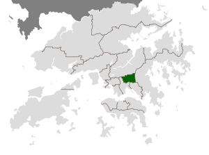
 Location of Wong Tai Sin District within Hong Kong |
|
| Basic data | |
| Country | People's Republic of China |
| Special Administrative Region | Hong Kong |
| surface | 9.3 km² |
| Residents | 425,235 (2016) |
| density | 45,724 inhabitants per km² |
| founding | September 1981 |
| ISO 3166-2 | HK |
| Website | Wong Tai Sin District Council (en, zh) |
| politics | |
| Chairman | Hui, Kam Shing 許錦成 (as of May 2020) |
| Political party | ADPL ( 民 協 ) |
|
|
|
Coordinates: 22 ° 20 ′ 1 ″ N , 114 ° 11 ′ 49 ″ E
Wong Tai Sin District ( Chinese 黃大仙 區 / 黄大仙 区 , Pinyin Huángdàxiàn Qū , Jyutping Wong 4 daai 6 sin 1 - "Wong Tai Sin District") is one of the 18 districts of Hong Kong . The district got its name from the Taoist Wong Tai Sin temple of the same name .
description
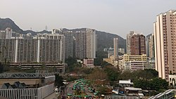
Wong Tai Sin District is inland to the north of Kowloon and is the only district in Hong Kong without a coast or access to the sea. Today the district is almost exclusively a residential area . The former flourishing industrial area of the district is located in the southeast in the village of San Po Kong ( 新 蒲 崗 ). In the course of the urban restructuring and renovation measures, many of the typical multi-storey factory buildings from the 1960s were gradually demolished until 2007 and new high-rise apartment buildings were built in their place. Some buildings were rebuilt and given a new use, for example as a parking garage . The area of the district has roughly the shape of a lying rectangle with the edge lengths 2.4 × 3.9 km. In the east, the district is separated from the neighboring Sai Kung District by a forested chain of hills, the peaks of which are 500 - 600 m high . The northern boundary is formed by the New Territories highlands , including the Lion Rock as a prominent point , which is a little north of the district. To the west, Chuk Yuen Road and Junction Road form a longer section of the border to the neighboring Kowloon City District . In the south, the district borders the Kowloon Walled City Park , which was built on the area of the former Walled City , which was demolished in 1994 . Most of the southern boundary is Prince Edward Road East . The district is made up of the following districts: Diamond Hill ( 鑽石 山 ), Wang Tau Hom ( 橫 頭 磡 ), Lok Fu ( 樂 富 ), Chuk Yuen ( 竹園 ), Wong Tai Sin ( 黃大仙 ), Tsz Wan Shan ( 慈雲 山 ), Fung Wong ( 鳳凰 ), Choi Hung ( 彩虹 ) and Choi Wan ( 彩雲 ).

population
In 2016 the district had 425,235 inhabitants on an area of 9.3 km². In terms of population, the district was eighth and in terms of area second to last among the 18 districts in Hong Kong (as of 2016). In terms of social structure, Wong Tai Sin District is one of the poorest districts in Hong Kong. In 2018, 29.2 percent of residents lived in a condominium (Hong Kong average: 49.2%), the median monthly household income was HK $ 28,300 (Hong Kong average: HK $ 35,000), and 77 percent of district residents had a higher level of education (At least secondary education , Hong Kong average: 82.1%). All three scores were the lowest of any Hong Kong district. In addition, the Wong Tai Sin District had the highest proportion of the elderly population of any district.
history
Until about the middle of the 20th century, Wong Tai Sin, north of historic Kowloon, was a relatively tranquil, rural area. Towards the end of the Chinese Civil War (1927-1949) and in the two decades that followed, Hong Kong was inundated by millions of refugees from the People's Republic of China , which was founded in 1949 . The existing living space was nowhere near enough to accommodate them and so it came to the emergence of extensive irregular hut settlements ( squatter settlements - land squatter settlements ) in the outskirts of Kowloon, including Wong Tai Sin. The former British colonial administration began in the 1950s with a housing program, which was initially financed mainly privately and later also by the state. (see also New Towns in Hong Kong ) The houses built in the resettlement area ( 徙 置 區 / 徙 置 区 ) grew over the years and offered their residents more and more comfort - initially the apartments had neither their own kitchen nor their own Water supply or bathroom or toilet. This is how today's living space in Wong Tai Sin was created. Due to its geographical proximity to the now demolished Kai Tak Airport , the town of San Po Kong in the southeast was a coveted industrial location in the 1960s, which was also the origin of the unrest in Hong Kong in 1967 , which at the time started as wage strikes between factory owners and the poorly paid simple people Workers began.
As part of the 2019 Hong Kong protests , the district was also the scene of clashes between protesters and police.
particularities
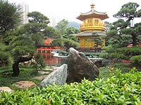
The Wong Tai Sin Temple is named after a Daotist saint and serves as a sanctuary for three religions - Daoism , Buddhism and Confucianism . The Buddhist women's monastery Chi Lin ( 志 蓮 淨 苑 , English Chi Lin Nunnery , ) was founded in 1934 and rebuilt in the 1990s in the architectural style of the Tang Dynasty . Just south of it is the serving for recreation small, 3.5 hectare Nan Lian Garden ( 南蓮園池 , English Nan Lian Garden , ), which was also established in the Tang-style and opened in November 2006 to the public .
![]()
![]()
Web links
Individual evidence
- ↑ Welcome message. Wong Tai Sin District Council website, accessed May 21, 2020 (Chinese, English).
- ↑ 嶺南 大學 - 思想 香港 - 社工 式 議員 與 地區 工作 - Lingnan University - Thinking Hong Kong - Social Worker Delegate and Local Welfare Work. Lingnan University , accessed May 22, 2020 (Chinese).
- ↑ Wong Tai Sin. discoverhongkong.com, accessed November 5, 2019 .
- ↑ Boundaries determined according to OpenStreetMap .
- ^ Area by District Council (Base on 2018 District Council). Suvery and Mapping Office / Lands Department, accessed October 21, 2019 .
- ↑ Demographic Profiles of Population in the Whole Territory, 2016. bycensus2016.gov.hk, accessed on October 21, 2019 .
- ↑ 按 區 議會 分區 劃分 的 人口 及 住戶 統計 資料 - Population and Household Statistics Analyzed by District Council District. Census and Statistics Department, Hong Kong Special Administrative Region, March 2019, accessed October 22, 2019 (Traditional Chinese, English).
- ↑ Mark Sharp: Hong Kong in pictures: when squatter huts covered hillsides. South China Morning Post , March 6, 2018, accessed October 24, 2019 .
- ^ Memories of Home - 50 Years of Public Housing in Hong Kong. ( pdf 421kB) heritagemuseum.gov.hk, accessed on October 24, 2019 (English).
- ↑ Elson Tong: Chaotic showdown in Wong Tai Sin as angry residents clash with riot police firing tear Hong Kong gas. Hong Kong Free Press, August 4, 2019, accessed October 24, 2019 .
- ↑ Chi Lin Nunnery and Nan Lian Garden. discoverhongkong.com, accessed October 21, 2019 .
- ^ My Districts - Wong Tai Sin District. Hong Kong Home Affairs Department, accessed October 21, 2019 .


