Charcot Island
| Charcot Island | ||
|---|---|---|
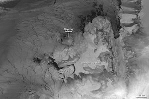
| Infrared image August 2009 ( Terra satellite ) | ||
| Waters | Bellingshausen Lake ( Southern Ocean ) | |
| Geographical location | 69 ° 58 ′ S , 75 ° 5 ′ W | |
|
|
||
| length | 48 km | |
| width | 40 km | |
| surface | approx. 1500 km² | |
| Highest elevation |
Mount Monique 1000 m |
|
| Residents | uninhabited | |
| Location of Charcot Island west of Alexander I Island | ||
The Charcot Island (also Charcotland ) is an island in the Antarctic 100 km west of Alexander Island in the Bellingshausen Sea .
geography
The 48 km long and 40 km wide island is covered with ice, with the exception of the Marion Nunataks , a 12 km long and mean 600 m high mountain range on the north coast. The height of the peaks of Mount Martine at the western end of the mountain range and Mount Monique at the eastern end is 750 m to 1000 m above sea level.
A partially ice-free area around the Marion Nunatakker with an extension of 9.2 km in north-south direction and 19.2 km in east-west direction is classified as a specially protected area of Antarctica No. 170 ( Antarctic Specially Protected Area No. 170 ) according to the Environmental Protection Protocol to the Antarctic Treaty .
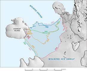
The last connection to the Wilkins Ice Shelf broke in 2009 . The current radar image of the area between Charcot Island and the Wilkins Ice Shelf shows the 'Webcam' from Space operated by ESA (see web links).
research
On his second Antarctic expedition with the three-master “ Pourquoi-Pas? “ Jean-Baptiste Charcot discovered an area on January 11, 1910, which he named Charcotland on the recommendation of Edwin Swift Balch (1856–1927) in honor of his father, the neurologist Jean-Martin Charcot . The island character of Charcotland was determined by Hubert Wilkins during a sightseeing flight over the area on December 29, 1929.
The destroyers of the United States Navy USS Brownson (DD-868) took on 10 February 1947 as part of Operation Highjump an unsuccessful attempt to land on the north coast of the island.
The Ronne Antarctic Research Expedition (RARE) took aerial photographs of parts of the island and carried out a first air landing on December 23, 1947. A runway and a makeshift 30 m² hut were built in 1982 near Mount Martine by the Chilean Antarctic Expedition and the Chilean Air Force . Geologists and biologists from the British Antarctic Survey made about ten brief research visits to Charcot Island from 1975 to the present day.
Web links
- 'Webcam' from Space Envisat Advanced Synthetic Aperture Radar (ASAR)
- Charcot Island, Antarctica Terra (satellite) , MODIS (image from August 2, 2009)
Individual evidence
- ↑ ASPA 170: Marion Nunataks, Charcot Island, Antarctic Peninsula in the Antarctic Protected Areas Database on the Antarctic Treaty Secretariat website (English, Spanish, French, Russian), accessed November 16, 2019
- ↑ Antarctic Ice: Large cracks discovered in Wilkins' shield. DER SPIEGEL , December 1, 2008, accessed December 12, 2009 .
- ^ Wilkins pack ice: Ice bridge breaks in Antarctica. DER SPIEGEL , April 5, 2009, accessed December 12, 2009 .
- ^ A b John Stewart: Antarctica - An Encyclopedia . Vol. 1, McFarland & Co., Jefferson and London 2011, ISBN 978-0-7864-3590-6 , p. 306


