Charlestown (Ireland)
| Charlestown Baile Chathail |
|||
 Charlestown, Mayo |
|||
| location | |||
| Coordinates: | 53 ° 58 ′ N , 8 ° 48 ′ W | ||
|
|||
| Data | |||
| Province: | Connacht | ||
| County: | Mayo | ||
| Height: | 69 m above sea level NHN | ||
| Residents: | 1033 (2016) including Bellaghy |
||
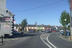
Charlestown ( Irish : Baile Chathail ) is a place in County Mayo in the west of the Republic of Ireland .
Charlestown is far to the east of County Mayo, almost on the border with County Sligo and a few miles from County Roscommon . It was built in the mid-19th century directly adjacent to Bellaghy in County Sligo ; since the initiative came from the town planner of a Viscount Dillon, the place was originally called Newtown-Dillon in English . At the 2016 Census , Charlestown and Bellaghy together had 1,033 people.
The fame of Charlestown is mainly due to the fact that the small town is located at the intersection of two first-class national roads: The east-west N5 from Longford (as an extension of the N4 from Dublin ) to Castlebar / Westport into central Mayo intersects with that of North-south trending N17 from Sligo Town to Galway City . Until the opening of a bypass in the course of the N5 at the end of 2007, this led to constant traffic jams in the town; the busy N17, however, continues to cross Charlestown.
The town is no longer connected to rail traffic in Ireland . However, Knock Airport is 3.5 miles south of Charlestown on the N17 . The closest larger town is Swinford to the west on the N5.
Personalities
- Joseph Cassidy (1933–2013), Archbishop of Tuam
Web links
Individual evidence
- ↑ Map of Ireland (can be enlarged greatly)
- ↑ Charlestown - Bellahy (Town) on citypopulation.de, accessed on 24 October 2017
- ↑ RTÉ News : Charlestown bypass opened , November 2, 2007
