
Charlestown Elevated
| Charlestown Elevated | |||||||||||||||||||||||||||||||||
|---|---|---|---|---|---|---|---|---|---|---|---|---|---|---|---|---|---|---|---|---|---|---|---|---|---|---|---|---|---|---|---|---|---|
 City Square Station
| |||||||||||||||||||||||||||||||||
| Type | Elevated railway | ||||||||||||||||||||||||||||||||
| place |
Massachusetts United States |
||||||||||||||||||||||||||||||||
| Number of stations | 5 | ||||||||||||||||||||||||||||||||
| Route system |
Boston Elevated Railway Orange Line |
||||||||||||||||||||||||||||||||
| opening | 1901 | ||||||||||||||||||||||||||||||||
| closure | 1975 | ||||||||||||||||||||||||||||||||
|
|||||||||||||||||||||||||||||||||
The Charlestown Elevated was designed as an elevated section of today's Boston Orange Line subway in the state of Massachusetts in the United States . The route led from the rise on Canal Street near Boston Garden via Charlestown to Everett . Construction of the line began in 1899, and the first trains rolled over the tracks in June 1901.
The Orange Line was diverted to Malden via a mixed underground and surface route in 1975 ; the new Washington Street Elevated route followed in 1987. Shortly before the new Orange Line route opened on April 7, 1975, the Charlestown Elevated route was opened on April 4th. Closed April 1975.
Shortly after it was shut down, the line was demolished. Remnants of the bridge over the Mystic River still stand north of the Route 99 bridge on Alford Street , and some piers of varying sizes recall the rise on Canal Street . In the middle of the Charlestown Bridge remains of the elevation can also be seen. The Tower C , which at the junction between the Charlestown Elevated and the Atlantic Avenue Elevated was, was in the Seashore Trolley Museum added.
gallery

Construction phase, 1899

Elevated railway on Canal Street rise

Sullivan Square Station , 1905

The Charlestown Bridge , 1929
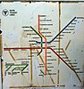
This MBTA map from 1967-1969 shows the route of the Charlestown Elevated

Remnants of Canal Street Incline

Pillar on the Charlestown Bridge

Pillar in Sullivan Square

Bridge piers of the former bridge over the Mystic River


Individual evidence
- ^ Charlestown Postcards . WITH. Retrieved December 25, 2011.
- ↑ a b Main Line Elevated Photos . Celebrate Boston. Retrieved December 29, 2011.
Web links
Atlantic Avenue Elevated (1901-1938) | Boston Elevated Railway (1887–1947) | Charlestown Elevated (1901-1975) | Green Line A (1856-1969) | Eastern Massachusetts Street Railway (1892–1968) | Middlesex and Boston Street Railway (1891–1972) | Washington Street Elevated (1901-1987)