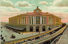
Atlantic Avenue Elevated

The Atlantic Avenue Elevated was an elevated train in the eastern city center of Boston in the state of Massachusetts of the United States . It was an alternative route to the main line of the Boston Elevated Railway (today's route of the Orange Line ) around the Washington Street Tunnel . The Atlantic Avenue Elevated was in operation from 1901 to 1938 and was demolished due to insufficient passenger numbers.
history
The Atlantic Avenue Elevated was originally part of a larger mass transit system by the Boston Transit Commission planned in 1896th After the success of the Tremont Street Subway (now the Green Line ), the commission began to work out alternatives for a unified system that would serve all of downtown Boston and adjacent suburbs. According to the concept, there should be two corridors for elevated trains - on one side of the Washington Street Subway (now Orange Line ) below Washington Street from a portal on Oak Street to Haymarket and on the other side a completely elevated stretch along the Atlantic Avenue . At the time of planning, Atlantic Avenue was the center of the fishing and shipping industries in Boston and served many ferry docks.
Below Atlantic Avenue Elevated , the Union Freight Railroad ran on Atlantic Avenue and Commercial Street and carried cargo between the lines that ended at North Station and South Station .
1901 to 1919
When it opened in 1901, Atlantic Avenue Elevated ran through the Tremont Street Subway and went from a subway to an elevated train on the climbs of Pleasant Street and Causeway Street . The platforms at the stops not on the elevated railway had to be equipped with removable, higher platforms so that the passengers could get out of the car. Where Washington Street Elevated branched off in a westerly direction from Washington Street onto Castle Street (now Herald Street ), there was a complete three-way intersection ( Tower D ) with Atlantic Avenue Elevated .
The route turned north after a block on Harrison Avenue and led to Beach Street , where it turned east to its first stop of the same name. From there the route ran north on Atlantic Avenue to the second station, South Station , from where there were connections to South Station with further inner-city connections and commuter trains and, from 1916, also to the Cambridge-Dorchester Tunnel (now the Red Line ). The next stop was Rowes Wharf on Broad Street and High Street with transfer options to Boston, Revere Beach and Lynn Railroad by ferry from Rowes Wharf to East Boston .
In the further course along Atlantic Avenue , State Street on the street of the same name was the next station, which from 1904 offered a transfer option to the East Boston Tunnel (today the Blue Line ). The following station, Battery Street, provided access to Boston's North End . South of that on the east side of the road was the Lincoln Wharf generator station of the Boston Elevated Railway . The Atlantic Avenue Elevated ended on Keany Square , from where the Charlestown Elevated covered the northern section of the main line. Here, too, there was a three-way intersection ( Tower C ), which led Charlestown Elevated west onto Causeway Street and then north over the Charlestown Bridge .
In 1908, the Washington Street Tunnel was opened and the route of the main line was redesigned. In this context, the Tremont Street Subway was again released exclusively for rail vehicles. As a consequence, the southern intersection ( Tower D ) was reconfigured and the main line led north on the east side of Washington Street to the tunnel.
The route south of South Station had to be closed after a fatal accident in the tight bend near Harrison and Beach in July 1928 and was replaced by shuttles between South Station and North Station on Charlestown Elevated . In 1919, which was Atlantic Avenue Elevated by the Great Molasses Flood of north Battery Street severely damaged.
1920 to 1942
In the early 1920s, the once thriving fishing and shipping industries in Boston were hit by hard times, already causing a decline in the number of passengers on Atlantic Avenue Elevated . With the completion of the Sumner Tunnel and the cessation of ferry services in Boston Harbor , the number of passengers between North Station and South Station collapsed almost completely. This section of the route was closed on October 1, 1938 and demolished in 1942 to meet the material requirements for the Second World War .
Individual evidence
- ↑ MBTA Orange Line. Retrieved February 17, 2012 .
- ^ History. About the MBTA. Retrieved February 17, 2012 .
- ^ Romin Koebel: Boston Transit Milestones. In: MIT . Retrieved February 17, 2012 .

