
Washington Street (Boston)
| Washington Street | |
|---|---|
|
|
|
 |
|
| The Old South Meeting House on Washington Street | |
| Basic data | |
| place | Boston |
| District | Downtown Crossing , South End , Jamaica Plain , Forest Hills , Roslindale |
| Created | 4th July 1788 |
| Hist. Names | Norfolk and Bristol Turnpike |
| Connecting roads | US Highway 1 , Broadway |
| Cross streets | Interstate 93 , Route 3 , State Street , Pie Alley , School Street , Boylston Street , Massachusetts Turnpike , Massachusetts Avenue , Arborway , Stony Brook Reservation Parkways , Route 1A , Route 27 , US Highway 1 , Route 140 , Interstate 495 , Route 120 , Interstate 295 , Route 123 , Interstate 95 |
| Places | Dudley Square , Stony Brook Reservation |
| Buildings | Charlestown Bridge , Old State House , Old South Meeting House , One Boston Place , MBTA station Downtown Crossing , MBTA station Forest Hills , Gillette Stadium |
| use | |
| User groups | Pedestrian traffic , bicycle traffic , motor traffic , public transport |
| Technical specifications | |
| Street length | approx. 37 mi (59.5 km ) |

The Washington Street is about 37 mi (59.5 km) of road in the state of Massachusetts of the United States . It leads from the Boston city center Downtown Crossing in a southwesterly direction to the state border of Rhode Iceland . Much of the route was built as the Norfolk and Bristol Turnpike in the early 19th century , but its history dates back to the 1780s. The Washington Street is the longest street in Boston and one of the longest in the state of Massachusetts. Many of the streets that cross Washington Street change names across the street, as Washington Street was the first street to connect the Shawmut Peninsula to the mainland.
Route

The Washington Street starts under the name North Washington Street at the intersection of New Rutherford Avenue and Chelsea Street north of Charlestown Bridge . The route ends north of Haymarket Square , where it joins the road above the Big Dig , due to the development of which the road is interrupted at this point.
It starts again at the intersection of State Street and Court Street and initially continues as a one-way street south. The section in Downtown Crossing from Milk Street to Temple Place is - like the part further north - only accessible to authorized vehicles. Only at Stuart / Kneeland Street will the street be passable in both directions. The section from Marginal Street up to and including the bridge over the Massachusetts Turnpike and the adjacent tracks of the Amtrak or Massachusetts Bay Transportation Authority (MBTA) is again only accessible in a northerly direction, although there is one lane opposite for the buses of the Silver Line the direction of travel.
From Dudley Square in Roxbury , Washington Street to Dudley Street is a one-way street in the south. Traffic in a northerly direction bypasses this section further east. After crossing under the Arborway in Jamaica Plain, the street becomes Hyde Park Avenue . South of the MBTA station Forest Hills , however, the Ukraine Way be used across the tracks to get back to the now west of the tracks as a continuation of South Street running Washington Street to arrive. On the border between Roslindale and West Roxbury, the road crosses West Roxbury Parkway and has a median strip from here that accompanies you to the city limits to Dedham .
The Washington Street continues in a southwesterly direction through the center of Dedham , the outskirts of Westwood and through the centers of Norwood , East Walpole and South Walpole . The road ends at the border between Walpole and Foxborough , but continues in a southerly direction offset slightly east as US Highway 1 ( Boston-Providence Turnpike ). This can be reached via a short stretch of Water Street . As far as the state line in Rhode Island , the route leads through North Attleborough , past Gillette Stadium in Foxborough, Wrentham , Plainville and South Attleborough .
history
The section of Washington Street from downtown Boston to Dudley Square in Roxbury was the first street to connect the then small city of Boston to the mainland by taking Boston Post Road to New York City . The street was originally led under different names on this section: Cornhill from Adams Square (south of today's Boston City Hall ) to School Street , Marlborough Street to the intersection of Summer Street and Winter Street , Newbury Street to the intersection of roads Essex Street / Boylston Street and finally Orange Street next to the fort near the present East Berkeley Street .
On July 4, 1788, the section south of the fortification to the Roxbury city limits was named Washington Street . This designation was extended on July 6, 1824 to the northern sub-areas up to Adams Square , and on November 6, 1872 a new street was added to Haymarket Square in a northerly direction. The part north of Roxbury Street in Roxbury has existed as a public way since January 19, 1662 and was renamed Washington Street on May 9, 1825 . Gradually, streets further west along Roxbury Street , Tremont Street and Huntington Avenue were renamed to the Brookline border .
The Norfolk and Bristol Turnpike was established in 1803 and served as a less curvy alternative to two previously much-used roads between Boston and Providence (Rhode Island) - specifically, the Lower Boston Post Road through Norwood and Foxborough and the road through Walpole and Wrentham . The southern half of the road, however, was only used to a limited extent due to the route being remote from the cities and was more or less a dust track until the 1930s . Only the construction of US Highway 1 from Boston to Providence improved the situation.
The section of the street in Roxbury was designated as a public street called Shawmut Avenue in June 1857 . On February 3, 1858, the section in West Roxbury was renamed accordingly. On July 2, 1860, Tremont Street was extended at its southern end along the former Washington Street to Brookline , so that Washington Street ended on Columbus Street . On June 16, 1874, the remainder of the street west of Dudley Square became Roxbury Street , and at the same time Washington Street was extended south from Dudley Square along the former Shawmut Street to Dedham .
The section of Washington Street north of Haymarket Square was known as Charlestown Street until around 1900 .
Transportation
Since Washington Street was used as the main street from the start, trams and bus routes ran along the route at an early stage .
A street map from 1871 (Fig. 1) already shows tram tracks running south from Boylston Street to Dudley Street . Further maps from 1874 show the extension of this route south to today's MBTA Forest Hills station and north to Dock Square . Around 1888, rails also led north along Washington Street to Haymarket Square and from 1897 to an area north of the Charlestown Bridge .
A map from 1899 (Fig. 2) shows that the tracks of the West Roxbury and Roslindale Street Railway extend southwest from Forest Hills via Dedham to Norwood . The Norfolk Southern Railway Street led from Norfolk to Walpole and used from there until after South Walpole the Washington Street . The remaining stretches of the road had no tram tracks except for a section of the Interstate Consolidated Street Railway through North Attleborough , as the road was too far from populated areas.
Another map from 1925 (Fig. 3) shows that the streetcar tracks on Washington Street in Boston ended on Essex Street in the city center. In the 1950s, however, the tram lines running there were replaced by buses.
On June 10, 1901 as predecessor opened today's Orange Line , the Washington Street Elevated , the first from the southern city center in Boston to Dudley and from 22 November 1909 until after Forest Hills led. On November 20, 1908, the Washington Street Tunnel opened . The Washington Street Elevated was on 30 April 1987 in the wake of the opening of Southwest Corridor closed and later demolished.
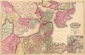
Fig. 1: Map from 1871

Fig. 2: Map from 1899

Fig. 3: Map from 1925


Classification
The Washington Street is currently classified in two places as a numbered street, namely, first as Massachusetts Route 1A (from the Elm Street in Dedham to Walpole Street in Norwood ) and secondly as US Highway 1 (from the northern Foxborough the near Gillette Stadium to Rhode Island ).
As part of the designation of the first numbered New England Interstate Highways in Massachusetts in 1922, US 1 was designated as part of Washington Street from North Attleborough via Norwood to the Arborway in Boston. In 1933 a new road from Roslindale to Foxborough was completed with the Boston-Providence Turnpike and Brook Farm Parkway , and the rest of the stretch to Rhode Island was also built at that time. The old route of US 1 was designated as Massachusetts Route 1A after the relocation .
More streets named Washington in Boston
There are two other major and two minor streets in Boston called Washington Street .
- In the Dorchester borough , 2.8 mi (4.5 km) long Washington Street extends from Blue Hill Avenue to Dorchester Avenue on the borough's southern border.
- In Allston and Brighton , Washington Street begins on the Brookline border and runs approximately 2 mi (3.2 km) to the Newton city limit . The entire street is 13.5 mi (21.7 km) long, starts in Brookline Village and runs through Brookline , Allston , Brighton , Newton and Wellesley to Natick .
- Another Washington Street exists in Hyde Park and leads there to the east side of the Neponset River .
- Fourth Washington Street is in Chinatown , where it begins at the intersection of Austin Street and New Rutherford Avenue and continues to Harvard Street .
Individual evidence
- ^ Woodbourne Historic District. Jamaica Plain Historical Society, accessed January 19, 2013 .
literature
- Edwin M. Bacon: Washington Street, old and new . a history in narrative form of the changes which this ancient street has undergone since the settlement of Boston. Macullar Parker Co., Boston 1913, OCLC 6607720 ( online in Google Book Search).
Web links
- Washington Street, The Longest In Boston. December 2004, accessed January 26, 2013 .
Coordinates: 42 ° 21 '24.5 " N , 71 ° 3' 32.3" W.