Shawmut Peninsula

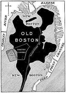
The Shawmut Peninsula is in the Indian language the name of the headland on which the city of Boston in the state of Massachusetts in the United States was built. The peninsula , which originally measured just under 789 acres (3.2 km² ), was almost doubled in area through land reclamation measures in the 19th century.
Geology and original topography
Like most of the landscape in Massachusetts, the Shawmut Peninsula was formed by glacial erosion and moraines caused by the retreat of glaciers at the end of the last ice age . The topography of the peninsula was determined by three hills : Copps Hill in what is now the North End , Fort Hill in what is now the Financial District and Trimountain in what is now Beacon Hill . Of the three hills, the Trimountain was by far the largest as a steep massif with three peaks . Over time, the name was shortened to Tremont . In the south there was a narrow isthmus with the Boston Neck , which connected the peninsula with the mainland at Roxbury .
Settlement by the British
The name Shawmut is derived from the Algonquian word Mashauwomuk , the actual meaning of which is not known. The first recorded use of the word Shawmutt to denote the peninsula dates back to 1630 when the hermit William Blaxton wrote to John Winthrop asking him to move his settlement from what is now Charlestown to the peninsula. There was not enough drinking water on the Charlestown Peninsula , while the Shawmut Peninsula had an "excellent well" on the north side - today's Beacon Hill .
Land reclamation
The first land reclamation projects were implemented in 1820 and continued until 1900. This created the Boston neighborhoods of South End , Back Bay and Fenway – Kenmore . The Back Bay Fens , an urban freshwater wilderness , are a remnant of the salt marshes that once surrounded the peninsula.
Although these projects, the ecosystem of the former wetlands destroyed and today's environmental legislation likely would not be eligible for approval, they were considered for two reasons as a great asset to the community: First, were the foul-smelling tidal flats eliminated by wastewater dirty had been, and second, building land was created that is now one of the most valuable lots in New England .
Individual evidence
- ^ A b Bradford A. Miller: Digging up Boston . The Big Dig Builds on Centuries of Geological Engineering. In: American Geological Institute (ed.): Geotimes . American Geological Institute, October 2002, ISSN 0016-8556 , OCLC 1643792 .
- ^ Even Norton Horsford: The Indian names of Boston, and their meaning . J. Wilson and Son, Cambridge 1886, OCLC 30103927 .
- ^ Nathaniel B. Shurtleff: A topographical and historical description of Boston . Printed by request of the City Council, Boston 1871, OCLC 4422090 .
Coordinates: 42 ° 21 '28 " N , 71 ° 3' 34" W.
