
Back Bay Fens
The Back Bay Fens , mostly simply called The Fens by the locals , is a parkland and urban wilderness in Boston in the state of Massachusetts in the United States . The site was designed by Frederick Law Olmsted as part of the Emerald Necklace . According to the Fens of the district are Fenway-Kenmore and Fenway Park named in which the Boston Red Sox are at home.


history

The Back Bay Fens are now part of the Emerald Necklace and form a picturesque park landscape. Basically, the site consists of a historical patch of salt marsh , which was surrounded by dry land and had no connection to the tides of the Atlantic Ocean . From this a park with fresh water , which is now also known as The Fens or Fenway , was created through appropriate gardening and landscaping . The latter term can also refer to the surrounding district.
When Boston was settled in the early 17th century, the Shawmut Peninsula on which the city was built was connected to Roxbury by a thin, sandy stretch of land called the Boston Neck . The marshland to the west was a mudflat area of the Charles River . The area began to smell increasingly bad over time, as the sewage from the growing settlement was led into it.
To serve the dual purpose of eliminating health and aesthetic problems from the contaminated water and reclaiming new and valuable land for Boston real estate, a series of land reclamation projects were initiated in 1820 and continued for the remainder of the century. The filling in of what is now Back Bay was finished in 1882, Kenmore Square was reached in 1890 and the Fens could be completed in 1900. These projects have more than doubled the size of the peninsula.
For Olmsted it was a great challenge to restore the marshland in such a way that it could become an ecologically healthy place and that could also be used as a recreational area. These combined Olmsted his talents as a landscape architect with the plumbing equipment to the then state of the art "scene of a winding, slightly salty Bach with wooded banks, the interest with and turned a putrid smelly tidal creek and marsh a meandering wakes course of the water."
Olmsted designed the fens so that the tides would flood them twice a day. In this way a regular water exchange took place, which was a significant improvement compared to before. However, in 1910 a dam was built at Craigie's Bridge , which cut off the mouth of the Charles River from the tides of the Atlantic and isolated the freshwater. In this way, the Fens became a freshwater lagoon that is regularly refreshed by runoff from the Charles River Basin .
A short time later, landscape architect Arthur Asahel Shurcliff , a protégé of Olmsted, added new features such as the Kelleher Rose Garden and shaped the more formal landscape style that was very popular in the 1920s and 1930s . At the same time, a sports field was added to the facility .
When the United States entered World War II in 1941, residents planted a Victory Garden in the Fens . This is still the last existing garden of its kind and is a highly valued community garden with flowers and various vegetables .
In 1961, a group of friends and neighbors in East Fenway gathered to discuss current affairs in their neighborhood and formed the Fenway Civic Association (FCA). Volunteers carried out projects to clean the streets, beautify the city and protect local residents from crime. Soon after, the FCA began advocating improved maintenance of parks and other elements to ensure a safe and pleasant neighborhood.
Buildings and works of art in the park
The Fenway / Richard D. Parker Victory Gardens
The Victory Gardens are now named after Richard D. Parker , who helped organize the gardens in 1941 and worked there as a gardener until his death in 1975 . It is thanks to his efforts that Victory Gardens at Fenway is one of only two remaining gardens from World War II in the United States today. During the war, much of the food grown there was sent to the armed forces and the remaining quantities were strictly rationed. The then US President Franklin D. Roosevelt stipulated that the citizens of the United States should grow their own vegetables. The city of Boston then designated 49 areas for the creation of gardens, including properties in the Boston Common and the Boston Public Garden . The Fenway Victory Gardens were established in 1941 and are still a central part of the Fenway community and well known by gardeners across the United States. Today the gardens are private land and are available to the residents of the Boston area, analogous to the German concept of allotment gardens , to grow their own vegetables or flowers.
The Agassiz Road Duck House

The Agassiz Road Duck House was designed by architect Alexander Longfellow and built in 1897. It was used exclusively as a public toilet , but had to be closed for reconstruction after a fire in 1986. The Duck House is in a prominent part of the Back Bay Fens right next to the Agassiz Road Bridge and is the only building along that street. The Agassiz Road is an important pedestrian connection between the districts of East - and West Fenway , though they for passenger cars only as a one-way street is designed. Much of today's building has been preserved in its original form, although the design of the roof was simplified in the course of the new construction after the 1986 fire. The house itself is not a sight in Boston, but its rustic style and connection to the park make the Duck House an important part of the Back Bay Fens . The city of Boston recently considered reviving the Duck House, for example by building a bicycle rental shop or a café nearby.
The fire alarm center
Since its establishment on December 27, 1925, the Fire Alarm Center has been located at 59 The Fenway , near the intersection of Westland Avenue and Hemenway Street . It is a neoclassical building limestone in the form of a villa with large, ornate bronze doors on one side.
The following inscription can be found on the front facade of the building:
"ERECTED BY THE CITIZENS OF BOSTON TO FORTIFY AND EXTEND THE PRINCIPLE OF ORGANIZED RESISTANCE TO THE SCOURGE OF FIRE, CONSECRATED AND DEDICATED TO THE SERVICE THROUGH WHICH THIS PRINCIPLE IS SO NOBLY PERPETUATED."
“Erected by the people of Boston to strengthen and expand the principle of organized resistance to the plague of fire. Blessed and dedicated to the ministry through which this principle is so honored. "
All lines for fire alarms as well as radio and telephone communication of the Boston fire department are controlled from here. The building has an independent generator in the event of a power failure.
The Westland Gate

In 1905 the main entrance to the Fens was relocated to the end of Westland Avenue , where Westland Gate now serves as the grand entrance to the park.
The memorial for Katharine Lee Bates
The Katharine Lee Bates Monument consists of a free-standing granite tablet with a bronze plaque embedded in it. It is located on Agassiz Road above the Muddy River and the Stony Brook Gatehouse . The plaque informs the viewer about the life of Bates and also contains parts from America the Beautiful , which she wrote at the end of the 20th century.
The John Boyle O'Reilly Memorial
Near the Westland Gate is the John Boyle O'Reilly Memorial. This memorial, created by Daniel Chester French in 1894 , commemorates the Irish poet and editor of the Catholic daily The Pilot . On the front there is a bust of O'Reilly, on the back a statue of Erin weaving a wreath of laurel and oak leaves for her sons poetry and patriotism . In the background there are Celtic calligraphies .
The John Endecott Monument
Located across from the Forsyth Dental Institute and Museum of Fine Arts on Forsyth Way, the memorial was originally the entrance to the Back Bay Fens on Huntington Avenue . The pedestal made of red granite carries the statue of John Endecott made of white granite. The statue itself shows him as a standing portrait and dressed in early colonial costume, consisting of a coat with a wide, square collar, knee breeches , buckled shoes and a long cloak . He holds his hat by his side in his right hand. The sculpture stands on a square base, which in turn protrudes from a large granite wall. This bears the inscription: "JOHN ENDECOTT 1588-1665". A low granite bench runs around the wall.
According to the inscriptions on one side of the monument, it was designed by architect Ralph Weld Gray and created by Carl Paul Jennewein in 1936 . On the reverse there is a long inscription entitled "Bequest George Augustus Peabody Esquire of Danvers, Massachusetts". "The legacy of George Augustus Peabody, well-born from Danvers, Massachusetts". The main inscription includes the seal of the Commonwealth of Massachusetts and the quote: “STRONG, VALIANT JOHN WILT THOU MARCH ON, AND TAKE UP STATION FIRST, CHRIST CAL'D HATH THEE, HIS SOLDIER BE, AND FAIL NOT OF THY TRUST -EDWARD JOHNSON 1654 ".
Sports ground
As part of the changes made to the Back Bay Fens by Arthur Shurcliff, a sports field was built in 1923. Two massive stone stands were added in 1926 and a gymnasium designed by William D. Austin was added in 1928 . This was demolished in the 1980s due to dilapidation and replaced by a simple warehouse in the Gothic style. The sports ground was later renamed the Joseph Lee Playground .
At an unknown time, two baseball fields were added. One of them is dedicated to baseball player and philanthropist Roberto Clemente , and the other was dedicated to local residents Brian and David Cobe from 1984 by placing a bronze plaque in a rock from Roxbury conglomerate and placing it right next to the field.
In the 1970s, two additional basketball courts were built and dedicated to Jim Bradley . In 2010, as part of the public-private partnership between the city of Boston and Emanuel College , the entire sports grounds were extensively renovated and brought up to the latest standards, including the demolition of one of the stone stands.
The Roberto Clemente monument
This monument was dedicated to the baseball player and philanthropist Roberto Clemente in 1973 . It consists of a 5 ft (2 m ) high stone block with a large bronze relief depicting Clemente and a brief inscription in Spanish and English : “Roberto Clemente: His three loves; Puerto Rico, baseball, and children. ", German." Roberto Clemente: His three loves; Puerto Rico, baseball and kids. ”The neighboring baseball field is also dedicated to him.
Japanese temple bell
The bronze bell was cast in 1675 by Tanaka Gonzaemon under the supervision of Suzuki Magoemon and consecrated to Bishamon , a Buddhist deity of children and happiness. The bell was made available to the Japanese war effort in 1940 but ended up on a rubbish heap in Yokosuku . Sailors from the USS Boston (CA-69) salvaged the bell after the end of World War II and offered it to the city of Boston in 1945. In 1953, Japanese officials officially handed the bell over to Boston as a symbol of world peace.
The Kelleher Rose Garden

In the early 20th century, public rose gardens became very popular, so that in 1930 the landscape architect Arthur Shurcliff created a rose garden including a fountain opposite the Museum of Fine Arts . There the general public as well as rose enthusiasts could learn everything interesting about the cultivation of roses and enjoy the flowers. A rectangular section was added to the area in 1933, at the southern end of which is a copy of the famous El Desconsol statue, which Barcelona had donated to Boston.
In 1975 the garden was renamed James P. Kelleher Rose Garden , who served as superintendent of horticulture in Boston's Parks and Recreation Department . In the late 20th century, the rose garden fell into disrepair, which made a complete restoration necessary. In 2001, the Emerald Necklace Conservancy, in partnership with the Parks and Recreation Department , brought together landscape architects, horticulturalists, and rose specialists to develop a comprehensive plan for the rose garden renewal.
Paths and plantings were re-cut based on the original plans, the mother earth was renewed and peat was applied. An irrigation system was installed as well as new signage to enable visitors to learn from the garden. In 2008 work on the rose garden was completed. Among other things, a restoration of the original, decorative fountain was planned for 2011 in order to bring it back to function after decades of non-use. This also includes the replacement of missing statues in the form of cherubs .
The Veterans Memorial Park
In 1948, the George Robert White Fund funded a group of first one, later three war memorials, arranged in a circle and located next to the rose garden, Agassiz Bridge, and a concert pavilion from which the visitor can walk to two gatehouses on top of the other Facing side of the Muddy River.
The first monument made of granite is dedicated to the Second World War and was created by the architect Tito Cascieri . It consists of a base and a desk , surrounded by a semicircular wall with names on bronze plaques. A large angel statue by John F. Paramino rests at the top of the monument next to an obelisk covered with bronze stars . This is the oldest and at the same time the largest monument at this point in comparison to the other two memorials in the immediate vicinity. In the 1990s, a plaque was set in the desk that rededicated the entire work of the three individual monuments as Veterans Memorial Park and honored US Sergeant Charles Andrew MacGillivary , who received the Medal of Honor in World War II and joined the army in Boston .
The second monument, which is much smaller than the first, is the Korean War Memorial . It consists of a stone square with an integrated map of Korea . The map is flanked by two stone slabs that can be used as a bench. The actual memorial consists of a square field with names arranged in three rows. At the top is the word "Korea" and the years "1950-1953".
The third monument in the installation is the Vietnam War Memorial and its structure is identical to the Korean War Memorial . The map shows the country Vietnam , the heading above the list of names reads "Vietnam" and "1962-1975".
The Robert Burns statue (implemented)
The granite base of the statue of Robert Burns can still be seen on the mule track behind the Boston Fire Alarm Office and off Agassiz Road . In 1910, The Burns Memorial Association in Boston held a competition to make a statue. The winner of this competition was the artist Henry Hudson Kitson , who completed the statue in 1919. In 1920 the then governor Calvin Coolidge inaugurated the statue. In the summer of 1975, however, she was transferred from Fenway to Winthrop Square (corner of Otis and Devonshire ). There are currently no plans to return the statue to its original location, according to the Boston Art Commission . Several streets that run near the Back Bay Fens bear the names of Scottish cities that appear in Burns' works , e.g. B. Peterborough , Kilmarnock and Queensbury . The statue is supposed to correspond with them as a sign of honor.
The Radio Operators memorial (implemented)
The base of this monument still stands on Agassiz Road next to the Agassiz Bridge , from where you can see the war memorials opposite the rose garden. The Radio Operators memorial was inaugurated after the Second World War and consisted of a sinking ship with the SOS signal affixed around the base in Morse code . The memorial commemorated the radio operators who lost their lives on merchant ships during the war. In the 1990s, at the request of veteran radio operators, it was transferred to Peddocks Island , where they had received their training. The island is part of the Boston Harbor Islands National Recreation Area and can be reached by water taxi .
The Stony Brook Gatehouse and Pumping Station
The Stony Brook Gatehouse was designed by Henry Hobson Richardson and consists of a slate roof with large wooden beams that rests on walls made of rounded stones of various sizes. The red mortar used to join the stones is similar to the material used in other Richardson works.
An identical building designed by Edmund Wheelright , a protégé of Richardson, is in the immediate vicinity. It was later added to accommodate pumps for the Boston Water and Sewer Commission . The Stony Brook Gatehouse has since been out of service, but was converted into the headquarters of the Emerald Necklace Conservancy with an attached visitor center in 2010 .
The bridges
Together with the Fenway , the Fens own or owned four large and four small bridges. Olmsted asked the architect Henry Hobson Richardson , with whom he had worked several times, to design these bridges. Although they are simpler than most of his other works, they nonetheless emphasize Richardson's love for rough stones and arched masonry . The bridges were built either from the conglomerate of rock found in the Parker Hill quarry in Roxbury or from the pink granite from Worcester typical of Richardson .
The bridges, not named for the roads that cross them, bear the names of prominent local families at the time the Back Bay Fens were built : Henry Lee Higginson , founder of the Boston Symphony Orchestra , and Louis Agassiz , a noted Harvard scientist College , whose daughter married Higginson.
Big bridges
Bowker overpass
At the northern end of the lagoon is Commonwealth Avenue to the north and directly to the west is the steel Bowker Overpass - girder bridge that connects Storrow Drive with Boylston Street . In 2011 there were efforts to tear down the bridge because it shares the Emerald Necklace and is not necessarily a feast for the eyes.
Boylston Street Bridge ( Richardson Bridge )
The largest bridge in the Back Bay Fens was built in 1883 and consists of a single brick archway lined with Worcester granite.
Agassiz Road Bridge
The bridge was built in 1887 and consists of a series of brick archways clad with conglomerate rock.
Higginson Circle Bridge ( Fens Bridge )
It was built from February 20 to November 17, 1891 and consists of both masonry and conglomerate stone. It has a clearance of 15 ft (5 m ) and is 96 ft (29 m ) wide. According to an 1892 document, the uncorrected construction cost at the time was $ 27,699.34 .
Brookline Avenue Bridge
This bridge was built in 1899 and demolished from 1954 to 1956. It is to be rebuilt from 2011 to 2013 as part of a river restoration project. The demolition came when the Muddy River was relocated into an underground canal in the 1950s and the river crossing was no longer necessary. As part of the restoration project, the river will be brought back to the surface and the bridge will be rebuilt by the United States Army Corps of Engineers .
Small bridges
Bridle-Path Bridge
Its construction began in August 1893 and was completed on August 13, 1894. Due to an extensive reorganization of the streets, it was demolished between 1954 and 1956. The stone arch bridge curved from Park Drive to a bridle path parallel to the Riverway . It will not be rebuilt as part of the restoration project.
Huntington Avenue Entrance Bridge
This footbridge leads from Forsyth Way into the Back Bay Fens and passes the Japanese Temple Bell. It was originally made of wood and was built by Arthur Shurcliff in 1923 when the area was redesigned. It was replaced in the 1980s by a reinforced concrete bridge with a granite cladding.
Museum Road Bridge
Also a pedestrian bridge, it leads from the Museum of Fine Arts in the Fens to a path next to the lagoon. It was originally made of wood and was built by Arthur Shurcliff in 1923 when the area was redesigned. It was replaced in the 1980s by a reinforced concrete bridge with a granite cladding.
Tremont Street Entrance Bridge
The Tremont Street entrance to Back Bay Fens has been renamed Evans Way Park in honor of the very same Evans who donated an entire wing to the neighboring museum. This bridge was originally made of wood and was built in 1923 as part of the redesign of the area by Arthur Shurcliff. It was destroyed by arson during a student revolt in 1964. However, the supporting pillars are still standing and there have been many unsuccessful attempts to reconstruct the bridge. It is expected that after the completion of the Muddy River restoration project, the bridge will also be rebuilt.
Current usage
Since the park is located in the catchment area of the Longwood Medical and Academic Area , in which, for example, Northeastern University , the Boston Conservatory , the Berklee College of Music , the Boston Latin School , the Museum of Fine Arts , the School of the Museum of Fine Arts , the Simmons College , the Massachusetts College of Art and design and the Harvard Medical School are located, is he a valued and highly frequented green space in the city.
The Fenway Civic Association works with public institutions to upgrade and beautify the park, reduce traffic and secure valuable resources.
The headquarters of the Emerald Necklace Conservancy is located in the park . She restores and manages the entire system of the Emerald Necklace through the concept of the Public Private Partnership .
Picture gallery

The Longfellow Duck House in autumn
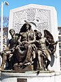
The John Boyle O'Reilly Memorial

The Japanese temple bell

Detail of the bell
.jpg)


Individual evidence
- ↑ a b Back Bay Fens. (No longer available online.) In: The Emerald Necklace Conservancy. Archived from the original on November 1, 2011 ; accessed on December 5, 2011 . Info: The archive link was inserted automatically and has not yet been checked. Please check the original and archive link according to the instructions and then remove this notice.
- ^ Fenway Civic Association. In: Fenway Civic Association. Retrieved December 6, 2011 (English, official website).
- ↑ Richard J. Berenson; Jon Marcus; Susan Cole Kelly: The complete illustrated guidebook to Boston's public parks and gardens . 1st edition. Produced for Silver Lining Books by Berenson Design & Books, New York 2002, ISBN 978-0-7607-2757-7 , pp. 54 .
- ↑ Immigrant Trail. In: Boston Innovation. Archived from the original on February 14, 2010 ; accessed on December 6, 2011 .
- ↑ Emerald Necklace Parks. (PDF; 1.0 MB) Walking and Running Distances. (No longer available online.) In: Emerald Necklace Conservancy. Archived from the original on April 11, 2010 ; accessed on December 6, 2011 . Info: The archive link was inserted automatically and has not yet been checked. Please check the original and archive link according to the instructions and then remove this notice.
- ↑ Sam Allis: Where's Winthrop? And why is the square that bears his name home to a statue of a Scottish poet? In: Boston Globe . January 18, 2010, accessed December 7, 2011 .
- ↑ Eric Moskowitz: Pothole renews debate on overpass. Neighbors want Bowker torn down. (No longer available online.) In: Boston Globe . March 12, 2011, formerly in the original ; Retrieved on August 12, 2012 (English, paid article). ( Page no longer available , search in web archives ) Info: The link was automatically marked as defective. Please check the link according to the instructions and then remove this notice.
Web links
- Official Boston Neighborhood Website (click Fenway-Kenmore )
- The Fenway Victory Gardens
- Photos from the end of summer in the Fens
- Kathy Poole: Boston's Back Bay Fens: a Sectional Story. 1997, accessed December 7, 2011 .
- Fenway Civic Association website
- Emerald Necklace Conservancy website
Coordinates: 42 ° 20 ′ 32.2 " N , 71 ° 5 ′ 34.9" W.
| Stations |
Boston Common • Boston Public Garden • Commonwealth Avenue • Back Bay Fens • Fenway • Riverway • Olmsted Park • Jamaica Pond • Jamaicaway • Arnold Arboretum • Arborway • Franklin Park • Dorchesterway • Park Drive |