Charles River
| Charles River | ||
|
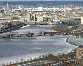
Longfellow Bridge over the Charles River |
||
| Data | ||
| Water code | US : 619357 | |
| location | Massachusetts (USA) | |
| River system | Charles River | |
| origin |
Echo Lake at Hopkinton 42 ° 11 ′ 34 " N , 71 ° 30 ′ 43" W. |
|
| Source height | 107 m | |
| muzzle | Boston Harbor Coordinates: 42 ° 22 ′ 14 ″ N , 71 ° 3 ′ 13 ″ W 42 ° 22 ′ 14 ″ N , 71 ° 3 ′ 13 ″ W |
|
| Mouth height | 0 m | |
| Height difference | 107 m | |
| Bottom slope | 0.83 ‰ | |
| length | 129 km | |
| Catchment area | 798 km² | |
| Big cities | Boston , Cambridge | |
|
Charles River catchment area |
||
|
John W. Weeks Bridge over the Charles River |
||
The Charles River is a relatively short river in Massachusetts that separates central Boston from Cambridge and Charlestown .
It is fed by around 80 brooks and a few aquifers. The Charles River originates in Echo Lake near Hopkinton and flows through 58 cities and villages in eastern Massachusetts before flowing into Boston Harbor. The Charles River covers a total of about 129 kilometers. Its catchment area includes 33 lakes and ponds. Despite the length of the river and despite its relatively large catchment area of 798 square kilometers, its source is only 42 kilometers from its mouth. In addition, the spring is only 107 meters above sea level.
Naming
The Charles River was named after Prince Charles , who later became King Charles I of England, Scotland and Ireland.


