Arborway
| Arborway | |
|---|---|
| Street in Boston | |
| The Arborway , 2007 | |
| Basic data | |
| place | Boston |
| District | Jamaica Plain |
| Created | 19th century |
| Places | Forest Hills Rotary Park |
| Buildings | Arnold Arboretum |
| use | |
| User groups | Car traffic , public transport |
| Technical specifications | |
| Street length | 1.2 mi (1.9 km ) |
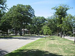
The Arborway is a four-lane, divided parkway and a two-lane residential street in Boston in the state of Massachusetts of the United States . The street is located in the Jamaica Plain district and was designed and built by Frederick Law Olmsted in the 1890s as the southernmost part of the Emerald Necklace parking system. Originally the street was designed for carriages to connect Boston Common to Franklin Park in Roxbury as part of the parking system .
The arborway begins at a large roundabout connecting it to Jamaicaway and passes the main entrance to the Arnold Arboretum , where parking is permitted on the lane. Originally the road continued through Forest Hills to Franklin Park, but now ends on South Street at the Arboretum. From there the trail leads either to Forest Hills or over the Casey Overpass towards Roxbury and Mattapan .
Web links
Individual evidence
Coordinates: 42 ° 18 ′ 8.6 ″ N , 71 ° 6 ′ 57.6 ″ W.
