
Quincy Quarries Reservation
|
Quincy Quarries Reservation
|
||
 Climbers in the protected area |
||
| location | Quincy , Massachusetts , United States | |
| Geographical location | 42 ° 15 ' N , 71 ° 2' W | |
|
||
| Setup date | 1985 | |
| Framework plan | Metropolitan Park System of Greater Boston | |
| administration | Massachusetts Department of Conservation and Recreation | |

The area Quincy Quarries Reservation is a State Park in Quincy in the state of Massachusetts of the United States . The park is administered by the Department of Conservation and Recreation (DCR) and is part of the Metropolitan Park System of Greater Boston . The quarries were hit by one of the first railways in the United States and delivered granite to nearby construction sites for over a century . Today, the rocks are a popular recreational area, especially among climbers .
history
Use as a quarry
After an intensive search across New England , Solomon Willard selected this site in Quincy in 1825 to mine stones for the Bunker Hill Monument in Charlestown . After some delays, on March 4, 1826, permission was granted to build a railway to facilitate the transportation of the granite. The railroad pioneer Gridley Bryant then designed and built the Granite Railway , which began operations on October 7, 1826.
The granite mined in the quarries became known throughout the United States, and stone working was soon the main industry in Quincy.
Later uses
The last active quarry was closed in 1963. After the closure, the quarries filled with rainwater and groundwater and soon attracted cliff divers. Due to the sharp-edged rocks lying below the waterline and the uneven depth of the pits, however, there were many injuries among the jumpers and also some deaths, so that the local police began to look for solutions for the abandoned quarry area together with the city administration.
Already at this time the quarries were discovered by climbers . The first book on the subject appeared in 1970.
In the 1980s, old telephone poles and trees were placed in the water-filled pits to prevent jumping off the cliffs. Unfortunately, the logs soaked up quickly and sank 2 ft (0.6 m ) below the surface from where they could not be seen by the jumpers. The number of injuries and deaths skyrocketed accordingly. Divers looking for missing cliff divers often found completely different people underwater instead of the one they were looking for.
Designation as a protected area
In 1985 the Boston Metropolitan District Commission acquired 22 acres (8.9 hectares ), including the quarries, and designated the entire area as a Quincy Quarries Reservation . A final solution to the safety problem could be found with the Big Dig , in which the excavated material was used to fill the quarries. This in turn opened up new opportunities for rock climbers, so the former quarries were expanded to support the public use of the protected area.
The sanctuary is connected to the hiking trails of the Blue Hills Reservation and offers not only sporting activities but also special views of the Boston skyline.
Some scenes of the films Gone Baby Gone - No Child's Play and The Invention of Lying shot in the old quarries.
gallery
- Quincy Quarries Reservation
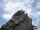
Rock formation with climbers
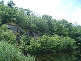
Quarry filled with water
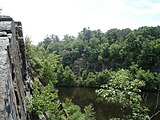
View from the edge of the quarry towards the south
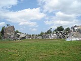
View over the earth-filled quarry


Individual evidence
- ^ William R. Crowther, Anthony W. Thompson: A climber's guide to the Quincy Quarries . MIT Outing Club, Cambridge, Mass. 1970, OCLC 40280112 .
- ↑ Richard Doucette, Susan Ruff: Boston Rocks . 2nd Edition. MIT Outing Club, Cambridge, Mass. 2003, ISBN 978-0-9601698-1-8 .
- ^ Robert Preer: Into Quarry's Depths no more. In: Boston Globe . October 18, 2001, accessed on September 11, 2012 (English, paid article).
- ↑ Filming locations for Gone Baby Gone - Not child's play in the Internet Movie Database (English)
Web links
- Official website
- Quincy Quarry and Granite Workers Museum. Retrieved September 11, 2012 .
- Victoria White: Debate On Over Risks In Quarries. In: The New York Times . August 21, 1988, accessed September 11, 2012 (article on the debate about the quarry filling in the 1980s).