Alewife Brook Parkway
| Alewife Brook Parkway | ||
|---|---|---|
| National Register of Historic Places | ||
| Historic District | ||
|
Course of the road |
||
|
|
||
| location | Cambridge and Somerville , Massachusetts , United States | |
| Coordinates | 42 ° 23 '19.3 " N , 71 ° 8' 35.9" W | |
| surface | 2.05 mi (3.3 km ) | |
| Built | 1908 | |
| architect | Charles Eliot , Olmsted Brothers | |
| NRHP number | [2] 04000249 | |
| The NRHP added | March 18, 2004 | |
The Alewife Brook Parkway is a parkway that over the urban areas of Cambridge and Somerville in the state of Massachusetts of the United States runs. The street has been listed as a Historic District on the National Register of Historic Places since March 18, 2004 . The entire length of the parkway is designated as part of Massachusetts Route 16 , while some of the southernmost sections are also designated as part of Massachusetts Route 2 and US Highway 3 , respectively . The parkway is administered by the Department of Conservation and Recreation (DCR) and is part of the Metropolitan Park System of Greater Boston .
Route
overview
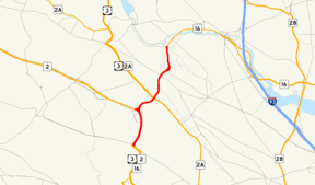
The parkway begins at Fresh Pond in Cambridge , where it connects to Fresh Pond Parkway via Concord Avenue . The road then continues north along the eastern border of the Alewife Brook Reservation to the Mystic River on the Medford city limits , where it becomes the Mystic Valley Parkway .
Detailed routing
The southern end of the parkway is formed by the west of the two roundabouts at Fresh Pond , where Concord Avenue connects the parkway with the Fresh Pond Parkway beginning at the east roundabout . To the north, the road is designated as Massachusetts Route 2 or US Route 3 and to the east as Massachusetts Route 16 . The parkway runs roughly north and leads east of the MBTA Alewife station to a large intersection that used to be a roundabout. There Route 2 continues west, while the Parkway from here runs north and parallel to Alewife Brook . It forms the western border between Cambridge and Arlington .
The parkway crosses Massachusetts Avenue , which runs Massachusetts Route 2A east towards Porter Square and Routes 2A and 3 west towards Arlington . The parkway continues parallel to Alewife Brook all the way to Somerville . After crossing Broadway , it takes a roundabout-like connection with Powder House Boulevard , then passes Dilboy Stadium and finds its northern end at a small roundabout where Alewife Brook joins the Mystic River . There the road meets the Mystic Valley Parkway , which runs from Arlington to Medford . The parkway is 2.05 mi (3.3 km ) in length.
history
The parkway was originally designed by landscape architect Charles Eliot as part of a larger road network designed for recreational and entertainment aspects, which was designed solely from an aesthetic point of view. The nearby Alewife Brook was straightened during construction and channeled between 1909 and 1912, allowing construction of the parkway to be completed in 1916. The landscaping was carried out by the Olmsted Brothers .
Further modifications were made to the south end of the parkway in the late 1980s. Among other things, a four-lane connecting ramp over the tracks of the Boston – Fitchburg railway line and new exits to shopping centers were built. The median was re-greened and new trees, street lights and cycle paths were integrated into the sidewalks. The renovation also included measures to improve accessibility at the bridge to the Rindge Towers , new pedestrian access to the Alewife MBTA station , the construction of the Alewife Linear Park and a cycle path to Jerry's Pond, as well as a dedicated truck delivery route for the nearby shopping centers .
Due to the steadily increasing traffic in the last century, the original aesthetics in the southernmost sections of the parkway have largely been lost. Today the road is the main link between Massachusetts Route 2 and the western suburbs on the one hand and between the city centers of Boston and Cambridge on the other, which is why a very high number of vehicles run there every day. The MBTA station in Alewife , shopping centers, multi-storey car parks as well as office and apartment buildings along the parkway also cause increased traffic.
See also
Web links
Individual evidence
- ^ Executive Office of Transportation - Office of Transportation Planning Roads
- ↑ Entry in the National Register Information System . National Park Service , accessed June 14, 2016
- ↑ Thomas C. Palmer Jr .: Ground finally broken for $ 10.7m Alewife Brook bridge. In: Boston Globe . August 27, 1993, accessed September 17, 2012 (English, paid article).
- ↑ Ronald Rosenberg: Panel Tables Bill To Scale Back Route 2 Project. In: Boston Globe . April 6, 1990, accessed September 17, 2012 (English, paid article).
- ^ A Cambridge Compromise. In: Boston Globe . July 1, 1989, accessed September 17, 2012 (English, paid article).


