
Middlesex Fells Reservation
|
Middlesex Fells Reservation
|
||
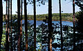
 The Middlesex Fells between the southern and central reservoir |
||
| location | Malden , Medford , Melrose , Stoneham and Winchester , Massachusetts , United States | |
| surface | 4.2 km² | |
| Geographical location | 42 ° 27 ' N , 71 ° 7' W | |
|
||
| Setup date | 1894 | |
| Framework plan | Metropolitan Park System of Greater Boston | |
| administration | Massachusetts Department of Conservation and Recreation | |

The Middlesex Fells Reservation , or simply the Fells , is a 2,575 acres (4.2 km² ) state park in Malden , Medford , Melrose , Stoneham and Winchester in the state of Massachusetts in the United States . The park is administered by the Department of Conservation and Recreation and is part of the Metropolitan Park System of Greater Boston . The park's administrative headquarters, including a visitor center (still under construction in 2012), are located at 4 Woodland Road in Stoneham .
background
The park is primarily used for walking, hiking , dog running , running , mountain biking , climbing, and skiing . In the park there is the Fells Reservoir, a reservoir that used to supply the city of Winchester with drinking water. The Spot Pond is a drinking water storage lake owned by the Massachusetts Water Resources Authority for the Quabbin Reservoir , but there are also many smaller pools and ponds that only carry water after the snow has melted in spring. In the summer months, sailing courses can be taken on the Spot Pond and boats can be rented. There are also two observation towers from which the area and the city of Boston can be viewed.
Instead of the Fells Reservoir , the three reservoirs North , Middle and South take over the drinking water supply of Winchester today . The Fells reservoir and the spot Pond are part of the Wachusett - water distribution system , which is considered one of six primary water systems Greater Boston supplied.
The trails leading into the park can be accessed from exits 33 and 34 of Interstate 93 .
history
The Middlesex Fells area was first explored by John Winthrop , Governor of the Massachusetts Bay Colony , in 1632. The land was initially used for logging , quarries and the production of ice , for which the village of Haywardville was built as a base within what is now the protected area. Many factories and mills were set up there, one of which was one of the first to manufacture vulcanized rubber products. Remnants of some of these buildings can still be viewed today in the NRHP- registered Spot Pond Archeological District , located in the Virginia Woods area of the reserve.
The area was made available to the Trustees of Reservations in 1891 through a donation from Virginia Wood through Charles Eliot . In 1893, the state took ownership and designated it a state park .
Recreational and leisure activities


As water can sail , with canoes motorboats are driven and fishing. On land there are specially designated routes for mountain bikes and bridle paths , the pedestrian paths invite you to walk, hike and run. There are picnic areas and playgrounds, as well as climbing rocks, and in winter there are opportunities for skiing and dog sledding .
Entries in the NRHP
In addition to the state park status , several parts of the area are listed on the National Register of Historic Places (NRHP). The area around Spot Pond east of I-93 is part of the Middlesex Fells Reservoirs Historic District , the paved paths of the park and its boundaries are listed as Middlesex Fells Reservation Parkways . The visitor center is located in the historic John Bottume House in Stoneham and is not far from the Metropolitan District Commission Pumping House from 1906. Historically relevant archaeological sites in the park are part of the Spot Pond Archeological District . In addition, the Fells Connector Parkways , which connect the park with the Mystic River Reservation in Winchester , also include roads outside of the NRHP. The same applies to the Lynn Fells Parkway , which connects the park with the Breakheart Reservation in Saugus .
Picture gallery

A small waterfall in December 2009

Sunset over South Reservoir , Fall 2009
The Middle Reservoir as seen from the dam separating it from the South Reservoir

The John Bottume House , which serves as a visitor center
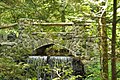
Bridge over an 18th century dam over Spot Pond Brook


Individual evidence
- ↑ a b Middlesex Fells Reservation. Department of Conservation and Recreation, accessed May 31, 2012 .