Mystic River Reservation
|
Mystic River Reservation
|
||
|
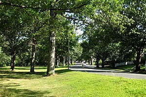
View of the park with the Mystic Valley Parkway in Arlington |
||
| location | Massachusetts , United States | |
| surface | 160.3 ha | |
| Geographical location | 42 ° 30 ′ N , 71 ° 19 ′ W | |
|
|
||
| Setup date | 1896 | |
| Framework plan | Metropolitan Park System of Greater Boston | |
| administration | Massachusetts Department of Conservation and Recreation | |

The Mystic River Reservation is a publicly owned, state park protected area along the Mystic River in the eastern state of Massachusetts in the United States . It is administered by the Department of Conservation and Recreation and is part of the Metropolitan Park System of Greater Boston . The park is part of the 75 mi² (194.25 km² ) catchment area of the Mystic River and is located in the urban areas of Winchester , Arlington , Medford , Somerville , Everett and Chelsea .
history
The reserve originally comprised just over 240 acres (100 hectares ) of land and has been gradually enlarged. In the early 20th century, most of the land along the Mystic River in Medford , Arlington, and Somerville became publicly owned and administered by the Massachusetts Department of Conservation and Recreation (DCR).
description
The protected area includes the four parks Draw Seven Park (Somerville), Torbert MacDonald Park (Medford), Mystic Lakes (Winchester, Arlington and Medford) and the Mary O'Malley Waterfront Park (Chelsea). The site is freely accessible every day from sunrise to sunset.
In 2010, the DCR published the Mystic River Master Plan, a concept for the restoration and further protection of the area. The proposed projects included a partnership between the DCR and the City of Medford to restore the Condon Shell (an open-air amphitheater near Medford Square ) and the Amelia Earhart Dam Basin Parklands . A link between the protected area, the Minuteman Bikeway and the MBTA station in Alewife was also planned, financed with 3.6 million US dollars from the US federal budget .
Leisure and recreational opportunities
The park offers opportunities for cycling , boating , hiking , rowing , running , sailing , playing football , swimming, and playing tennis .
Individual evidence
- ↑ a b c State Releases Mystic River Master Plan. (No longer available online.) InsideMedford.com, September 16, 2010, archived from the original September 17, 2012 ; accessed on August 30, 2012 (English). Info: The archive link was inserted automatically and has not yet been checked. Please check the original and archive link according to the instructions and then remove this notice.
- ^ Board of Paris Exposition Managers (Boston, Mass.); Massachusetts. Board of Metropolitan Park Commissioners: A history and description of the Boston metropolitan parks . Published under the authority of the Metropolitan Park Commissioners by the Board of Paris Exposition Managers, 1900 (accessed May 28, 2011).
- ↑ Mystic River Reservation. (No longer available online.) SomervillePatch, archived from the original on September 24, 2012 ; accessed on August 30, 2012 (English). Info: The archive link was inserted automatically and has not yet been checked. Please check the original and archive link according to the instructions and then remove this notice.

