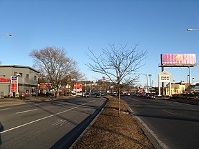
Revere Beach Parkway
| Revere Beach Parkway | ||
|---|---|---|
| National Register of Historic Places | ||
| Historic District | ||
|
The Revere Beach Parkway in Everett |
||
|
|
||
| location | Medford , Everett , Chelsea and Revere , Massachusetts , United States | |
| Coordinates | 42 ° 24 '7.5 " N , 71 ° 2' 40.5" W | |
| Built | 1899 | |
| architect | Charles Eliot , Olmsted Brothers | |
| NRHP number | [1] 07001241 | |
| The NRHP added | December 6, 2007 | |
The Revere Beach Parkway is a historic parkway in the northern suburbs of Boston in the state of Massachusetts in the United States , which was created in 1899 by the landscape architect Charles Eliot in cooperation with the Olmsted Brothers architectural office and connects the Mystic River Reservation and Revere Beach protected areas . The street is administered by the Department of Conservation and Recreation (DCR) and is part of the Metropolitan Park System of Greater Boston .
The road begins at Fells Connector Parkways in Medford and heads east through the Everett and Chelsea metropolitan areas to the intersection of Revere Beach Boulevard and Winthrop Parkway in Revere .
West of Massachusetts Route 1A , Revere Beach Parkway is designated as part of Massachusetts Route 16 and east of Route 1A as part of Massachusetts Route 145 .
The street was added to the National Register of Historic Places as a Historic District in 2007.
See also
- List of entries on the National Register of Historic Places in Middlesex County
- List of entries on the National Register of Historic Places in Suffolk County
Individual evidence
- ^ National Register Information System . In: National Register of Historic Places . National Park Service . Retrieved April 15, 2008.

