Blue Hills Reservation Parkways
| Blue Hills Reservation Parkways | ||
|---|---|---|
| National Register of Historic Places | ||
| Historic District | ||
|
The components of the road system |
||
|
|
||
| location | Quincy , Milton , Canton and Braintree , Massachusetts , United States | |
| Coordinates | 42 ° 13 '25 " N , 71 ° 4' 20" W | |
| Built | 1894 | |
| architect | Charles Eliot | |
| NRHP number | [1] 03000746 | |
| Data | ||
| The NRHP added | August 11, 2003 | |
| Declared as HD | August 11, 2003 | |
The Blue Hills Reservation Parkways is a group of historic parkways in the Blue Hills Reservation Conservation Area in the state of Massachusetts in the United States . They were designed by landscape architect Charles Eliot in 1894 and added to the National Register of Historic Places as a Historic District in 2003. The road system is administered by the Department of Conservation and Recreation (DCR) and is part of the Metropolitan Park System of Greater Boston .
Parkways of the road system
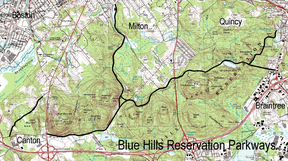
The Blue Hill River Road and Green Street are located in the city of Canton . The Chickatawbut Road runs from west to east by Milton , Quincy , Milton, Quincy and Braintree . The streets Hillside Street and Unquity Road are located in the city of Milton, and the Wampatuck Road lies entirely in Quincy.
Although the roads are part of the reserve, in many places one or both sides of the road are privately owned.


