Fenway
| Fenway | |
|---|---|
| Street in Boston | |
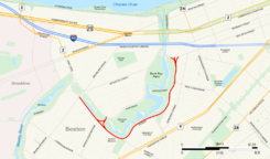
| Map with the course of the road marked in red | |
| Basic data | |
| place | Boston |
| District | Fenway – Kenmore |
| Created | 1876 |
| Connecting roads | Brookline Avenue , Boylston Street |
| Buildings | Isabella Stewart Gardner Museum , Museum of Fine Arts |
| use | |
| User groups | Car traffic , public transport |
| Road design | Parkway |
The Fenway , commonly referred to as The Fenway called, is a one- to three-lane parkway along the southern and eastern borders of the Back Bay Fens in the district Fenway-Kenmore in Boston in the state of Massachusetts of the United States . As part of the Emerald Necklace park system designed by Frederick Law Olmsted in the late 19th century , the Fenway , the Back Bay Fens and Park Drive connect Commonwealth Avenue Mall with the Riverway . The entire length of the Fenway runs along the Muddy River and is part of the Metropolitan Park System of Greater Boston . Like other parks in this system, it is administered by the Massachusetts Department of Conservation and Recreation .
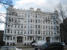
The Fenway was the first parkway constructed for the Emerald Necklace . Its name goes back to an early description of the park that runs parallel to the roadway, although the name could also advertise the high-quality district of Fenway-Kenmore . However, most of the early buildings there were designed for educational institutions . Today, the Isabella Stewart Gardner Museum , the Museum of Fine Arts and many colleges and universities are on the route.
background
In 1875, the Boston electorate and the Massachusetts legislature approved the establishment of a parks commission to prepare and promote the establishment of public parks in the city. The landscape architect Frederick Law Olmsted , who already the Central Park in New York City had designed, spent from this point much of his time in the area and was asked in the late 1870s by the Park Commission, of the outcome of a contest with 23 submitted proposals for the design of a new park to decide. Olmsted considered all of the competition entries unsuitable because, in his opinion, they either did not take into account the control of the tides or, on the contrary, did not take sufficient account of the aspects of a public park. The Muddy River and Stony Brook flowed through the Back Bay Fens , which at the time was exposed to the tides, storm surges, and sewage .
The Park Commission, disappointed with the verdict, asked Olmsted to join them as a professional consultant and landscape architect. Under his guidance, the construct now known as the Emerald Necklace took on tangible forms. He decided that the fens should be dredged, leveled, planted and turned into a near-natural salt bog to purify the running water. On this basis, Olmsted built a series of parks that stretched from the Fens near Commonwealth Avenue to Franklin Park a few miles away . The individual parking areas were connected by scenic parkways , which include the Fenway .
At the time of planning, it was expected that wealthy residents would live in the planned buildings along the Fenway and that the entire area would be upgraded to a high-class district. However, as the land values increased, a large number of educational institutions settled along the route . By 1907, 22 training and further education institutes had already settled there, including nine colleges and universities .
When erecting residential buildings, the appearance of the planned front facade had to be approved by the park administration, so that “a bad-looking building does not reduce the value of the entire district”. The administration was also free to decide whether a building applied for was generally suitable for the front along the park and parkway and therefore eligible for approval. With these measures and restrictions, the panel hoped to significantly improve the appearance of the Fenway compared to the neighboring streets.
As part of the Metropolitan Park System of Greater Boston , today's Fenway is administered by the Massachusetts Department of Conservation and Recreation (DCR), but not by the City of Boston.
Naming
In 1887, the entire system of streets and parkways from Boylston Street to Jamaica Pond was called the Parkway . The current names Fenway , Jamaicaway and Riverway were not approved by the Parks Commission until later that year. The suggested names for today's Fenway included Rumford , Longview and Riverdale , although the Park Commission had set precise criteria for naming it.
In the entire parking system, the name of every street should end uniformly “in order to support the project in a natural way, to bring the idea of continuity and uniformity closer to the public. And if the ending could be short, simple and common, it would be a relief in many ways. ”In addition, those responsible wanted the names to be“ derived from some topographical or historical circumstances in the area ”. For example, should be "a place of Parkway Riverdale Road better Riverway " be named. In an 1879 park and road map, the area through which the Fenway was to pass is described as a " fenny meadow ". The Commission therefore chose Back Bay Fens as the name for the park and Fenway as the name for the parkway that runs through the area.
Construction of the road
The Fenway was the first of the parkways designed by Olmsted, construction of which began in the 1880s. Construction of the others began in the 1890s. Work began on the connection to Boylston Street and proceeded rapidly, so that by 1885 most of the curbs and gutters were completed. Around 1888 the street up to Westland Avenue was finished, but it was stopped there due to a lack of filler material. The engineers' report said that construction on the section up to Brookline Avenue was halted because of problems with the filler material from the dredging of the new course of the Muddy River . After the rest of the land was developed, construction could continue, so that by 1890 the street to the intersection of Parker and Huntington Avenue (now Forsyth Way at the Museum of Fine Arts) was completed. Construction on the Fenway ended in early 1893 and the full length of the street opened shortly thereafter.
Description of the route

The Fenway begins at the intersection with Brookline Avenue and the Riverway and runs in three lanes in each direction south past Emmanuel College to the Avenue Louis Pasteur junction . From there, only the middle lane continues straight ahead, the outer ones turn off. The traffic in the left-turn lane will then be directed to Park Drive .
However, if you drive straight ahead, the Fenway becomes two-lane with oncoming traffic, ie one lane is available for each direction of travel. The route passes Simmons College and the Isabella Stewart Gardner Museum . The route then turns northeast at Louis Prang Street and from here has two lanes for each direction that lead past the Museum of Fine Arts and parts of Northeastern University . A short junction connects the Parkway with Westland Avenue and runs from there as a two-lane street in each direction past Berklee College of Music and the Boston Conservatory until it ends on Boylston Street . At the junction with Boylston Street stands a memorial to the writer and poet John Boyle O'Reilly from 1897.
The Park Drive , which on the opposite side of the Back Bay Fens skirts, begins at the end of Fenway at the Boylston Street and also leads to the Brookline Avenue past when the Fenway starts.
Individual evidence
- ^ The Proposed Parks . In: Boston Globe . Boston April 25, 1876.
- ↑ a b c Alexander Garvin: The American city. What works, what doesn't . 2nd Edition. McGraw-Hill, New York 2002, ISBN 0-07-137367-5 , pp. 60 ( limited preview in Google Book search).
- ↑ a b Alex Krieger, David A. Cobb, Amy Turner et al .: Mapping Boston . MIT Press, Cambridge 2001, ISBN 0-262-61173-2 , pp. 212 ( limited preview in Google Book search).
- ^ Robert Fishman: The American planning tradition . culture and policy. Woodrow Wilson Center Press, Washington 2000, ISBN 0-943875-95-1 , pp. 306 ( limited preview in Google Book search).
- ^ A b Alfred Emanuel Smith: New outlook . tape 86 . Outlook Pub. Co., New York 1907, OCLC 5361148 , p. 895 ( limited preview in Google Book Search).
- ↑ a b Boston (Mass.). Dept. of Parks: Annual report of the Park Department . Park Department, Boston 1912, OCLC 6980600 ( limited preview in Google Book Search).
- ↑ Christina Pazzanese: Mixed signals at a tricky intersection. In: Boston Globe . October 26, 2008, accessed December 9, 2011 .
- ^ Norman T. Newton: Design on the land . the development of landscape architecture. Belknap Press of Harvard University Press, Cambridge 1971, ISBN 0-674-19870-0 , pp. 597 ( limited preview in Google Book search).
- ^ A b c William Jackson: Annual report of the Park Department . Boston Park Department, Boston 1887, OCLC 6980600 , p. 26, 65–67, 71–73 ( limited preview in Google Book search).
- ↑ Cynthia Zaitzevsky: Frederick Law Olmsted and the Boston park system . Belknap Press, Cambridge 1982, ISBN 0-674-31830-7 , pp. 93 ( limited preview in Google Book search).
- ^ Lawrence W. Kennedy: Planning the city upon a hill . Boston since 1630. University of Massachusetts Press, Amherst 1992, ISBN 0-87023-780-2 , pp. 92 ( limited preview in Google Book search).
- ^ William Jackson: Annual report of the Park Department . Boston Park Department, Boston 1891, p. 51 ( limited preview in Google Book search).
- ^ William Jackson: Annual report of the Park Department . Boston Park Department, Boston 1894, p. 34, 71 ( limited preview in Google Book search).
- ↑ a b Emerald Necklace Parks. (PDF) (No longer available online.) In: The Emerald Necklace Conservancy. Archived from the original on April 11, 2010 ; Retrieved December 9, 2011 . Info: The archive link was inserted automatically and has not yet been checked. Please check the original and archive link according to the instructions and then remove this notice.
- ↑ a b Back Bay Fens, Boston. In: Google Maps . Accessed December 9, 2011 (overview map).
Web links
Coordinates: 42 ° 20 '25 " N , 71 ° 5' 42" W.

