
Harvard Bridge
Coordinates: 42 ° 21 '16 " N , 71 ° 5' 29" W.
| Harvard Bridge | ||
|---|---|---|
 |
||
| Convicted |
|
|
| Crossing of | Charles River | |
| place |
Boston and Cambridge Massachusetts , United States |
|
| Entertained by | Massachusetts Department of Transportation | |
| Building number | MA B16012 | |
| construction | Beam bridge made of steel , coated with concrete | |
| overall length | 2165.1 ft (659.9 m ) or 364.4 Smoots plus / minus an ear |
|
| width | 51.8 ft (15.8 m ) | |
| Number of openings | 25th | |
| Longest span | 105 ft (32 m ) | |
| Load capacity | 78.4 tons | |
| Clear height | 12 ft (3.7 m ) | |
| vehicles per day | 49,000 (as of 2005) | |
| start of building | 1887 | |
| completion | 1891; New building in 1990 | |
| opening | September 1, 1891 | |
| location | ||
|
||

The Harvard Bridge (also MIT Bridge , Massachusetts Avenue Bridge , Mass. Ave. Bridge or Xylophone Bridge ) is a concrete- clad, steel girder bridge in the state of Massachusetts in the United States . It connects the Boston district of Back Bay with the city of Cambridge by taking Massachusetts Route 2A (also Massachusetts Avenue ) over the Charles River . It is provided with a length of 2165.1 ft (659.9 m ) the longest bridge over the Charles River, with their length in the idiosyncratic unit Smoot is measured (the result is "364.4 Smoot plus / minus an ear") .
It was only after several attempts that the city councils of Boston and Cambridge succeeded in erecting the bridge as a swing bridge from 1887 to 1891 , in spite of the popular antipathy . In the following decades, the structure was overhauled several times and finally completely renewed in the late 1980s, as the vibrations no longer assumed acceptable proportions and an identical bridge collapsed for this reason.
The bridge was named after the Puritan theologian John Harvard .
Conception
The Massachusetts legislature passed the Acts of 1874 with Chapter 175 and Chapter 314, the necessary authorizations for the construction of a bridge between Boston and Cambridge. In fact, nothing happened until 1882, until Chapter 155 of the Acts of 1882 established more details about the construction of the planned bridge, including the exact location:
" Acts of 1882, Chapter 155, Section 1: The cities of Boston and Cambridge are authorized to construct a bridge and avenue across Charles river, from a point on Beacon street, in Boston, to a point in Cambridge, west of the westerly line of the Boston and Albany railroad. ... to the limitation that the line thereof shall not be north-east of a line drawn from the junction of Beacon street and West Chester park, in Boston, to the junction of the harbor line with Front Street, extended, in Cambridge, nor south-west of a line drawn from the junction of Beacon street, Brookline avenue and Brighton avenue, in Boston, to the junction of the Boston and Albany railroad with Putnam avenue, extended, in Cambridge. "
The bridge should be designed as a swing bridge and have a passage width of at least 38 ft (11.6 m ). The city of Boston did not like these plans, mainly because they did not allow the Boston and Albany Railroad to cross the bridge. So again nothing happened for three years until Chapter 129 of the Acts of 1885 limited the required opening width to a maximum of 36 ft (11 m ). This should continue to apply until the other bridges below the set position should have a larger opening.
Nothing happened after that until, in 1887, the City of Cambridge petitioned state law to get Boston to start construction. This led to the enactment of Chapter 282 in the Acts of 1887 , which was binding on both cities and they shared equally in the construction costs. In addition, the city of Boston was allowed to exceed its credit limit and borrow an additional US $ 250,000 (equivalent to approximately $ 6,920,000 today). The estimated construction cost of the bridge was half a million US dollars (equivalent to around $ 13,840,000 today).
The law authorized a commission to build the bridge, which was to consist of the mayors of the cities involved and a third person to be appointed by the mayors. If no agreement can be reached on this third person, the governor of the state should take over this task. But it did not get that far when Hugh O'Brien and Willam Russel were able to agree on Leander Greeley from Cambridge . Over time, the composition of the committee changed along with the political offices, as the following table shows.
| Composition of the bridge building commission over time | |||
|---|---|---|---|
| Period | Mayor of Boston | Mayor of Cambridge | Third member of the commission |
| 1887-1888 | Hugh O'Brien | Willam Russel | Leander Greeley |
| 1889-1890 | Thomas N. Hart | Henry H. Gilmore | |
| 1891 | Nathan Matthews | Alpheus B. Alger | Leander Greeley (died February 15 or 16, 1891) George W. Gale |
Its builders expected many advantages from the construction of the bridge. The formerly worthless plots on the Cambridge side had been filled in and upgraded to valuable land, so that the new bridge connected the city with the most valuable areas of Boston. In particular for the residents of the districts of Back Bay , South End and Roxbury it was hoped that the new, direct connection to Cambridge would bring far- reaching improvements, since Belmont and Arlington could also be reached more quickly than before. It was expected that the road over the bridge would develop into the central thoroughfare in both cities over time .
construction

The Acts of 1887 stipulated that the bridge should rest on wooden piers that were to be secured with stone foundations for the first 200 ft (61 m ), as the bank reinforcement was expected to require this space. However, this requirement was changed so that the entire bridge should consist of steel girders on stone foundations, and approved on July 14, 1887. The executive engineers were William Jackson , John. E. Cheney , Samuel E. Tinkham, and Nathan S. Brock .
The demands on the construction of the bridge were enormous, as the subsoil on which the structure was to be erected naturally presents some difficulties. There is a layer of clay beneath much of the Boston soil and a geological fault line runs along the Charles River . At a depth of 200 ft (61 m ) to 300 ft (91.4 m ), the soil is a highly compacted mixture of gravel , rubble , silt, and clay. Above that, to about 30 ft (9.1 m ) below the surface, is a pure layer of clay, the Boston Blue Clay (BBC) , and again above that are thinner layers of sand , rubble and other filler material. The BBC layer is highly consolidated to a depth of approximately 70 ft (21.3 m ) .
The substructure of the bridge originally consisted of two brick abutments , 23 brick river pillars and a pile foundation that supported a protective pillar for the rotating element. The upper structure consisted of 23 Gerber carriers made of steel and the rotating member . The abutment on the Boston side rests on piles sunk vertically into the ground, while on the Cambridge side it stands directly on the river bed.
Originally the bridge connected Boston's West Chester Park with Front Street in Cambridge; today the entire stretch on both sides of the river is referred to as Massachusetts Avenue . The total length - measured from the respective center of the two abutments - was 2,164 ft (659.6 m ), the width was given as 69.3 ft (21.1 m ). The centers of the piers were each 90 ft (27.4 m ) apart, and the span of each element was alternately 75 ft (22.9 m ) and 105 ft (32 m ), the longer beams being cantilevered and the shorter ones hung between them.
The lane leading over the bridge had two lanes for horse-drawn carriages and two tracks for trams with a total width of 51 ft (15.5 m ). Next to it were two 9.2 ft (2.8 m ) wide sidewalks. Both the carriageway and the side members of the pedestrian walkways were made of wood, with the sidewalks being covered with an approximately 1.25 in (31.8 mm ) thick layer of asphalt . The rotating element, however, was only 48 ft (14.6 m ) wide, about 149 ft (45.4 m ) long and was attached to a wooden pillar. It had an electric drive and a small house for the bridge keeper .
The bridge was opened on September 1, 1891. Construction costs, announced March 1, 1892, were $ 510,642.86 (about $ 15,000,000 today).
Naming

After the names Blaxton , Chester , Shawmut and Longfellow in particular were discarded, the bridge was named after the Puritan theologian John Harvard , whose name Harvard University also bears. Today's Longfellow Bridge opened 15 years later. Harvard was an early patron and financier of the university, but not, as is often believed, its founder.
Possibly due to the proximity to the structure, there are a large number of rumors at MIT regarding the name of the bridge, but all of them must be seriously doubted. This is mainly due to the fact that the bridge was built as early as 1891, while MIT did not move to its current location and thus in its immediate vicinity until 1916.
Maintenance and Events

In 1898, bike paths were installed next to the curbs . It was not until 2011, 113 years later, that the city of Boston connected its own cycle path network with the routes on the bridge.
Near the south-eastern end of the bridge there is a memorial stone to a jump of Harry Houdini from the Harvard Bridge reminds on May 1, 1908th Other sources date the jump to April 30 of the same year.
In 1909 the bridge was declared unsafe and required to replace all iron and steel elements. At the same time, the level of the bridge was raised slightly and the tram tracks were replaced.
When the Metropolitan District Commission (MDC) took control of Harvard Bridge in 1924 , the authority renewed much of the superstructure. In particular, the wooden beams were replaced by double-T beams made of steel and wooden elements of the deck were replaced by concrete and bricks . The tram rails were also replaced again. The rotating member was removed and replaced with two fixed segments, each 75 ft (22.9 m ) in length . The wooden bridge piers were heavily modified through the use of concrete and stones in order to visually match the other pillars. The number of stone pillars increased from 23 to 24.
In 1931, due to the ever-increasing volume of traffic at the intersection of Massachusetts Avenue and Memorial Drive, an underpass was built to replace the level crossing.
The structure was also known for a long time as the Xylophone Bridge , which was due to the special noises that the vehicles made when crossing the bridge. However, the roadway was replaced with a new surface made of concrete and bitumen in 1949 , and at the same time the tram rails were removed and replaced with street lamps . In addition, access ramps were added from Storrow Drive , which was still under construction at the time . In 1962 the pavement was replaced.
Technical investigation 1971–1972
The then Metropolitan District Commission (later merged into the Department of Conservation and Recreation ) commissioned a study for the technical investigation of Harvard Bridge in 1971/72 due to numerous complaints from users of the bridge in order to get to the bottom of the cause of the strong vibrations. As a result, it was found that the stability of the bridge was not sufficient for the loads that occurred. Before the study was completed, the recommendation was made to introduce a limit of 7.3 tonnes per axle or 14 tonnes per vehicle. Alternatively, trucks should only be allowed to use the inner lanes where the bridge was more stable. Notwithstanding these recommendations, a weight limit of 23 tons per vehicle was introduced.
The recommendations of the study included, among other things, a reinforcement of the existing structure by adding further construction elements to make it more stable in the longitudinal direction, as well as a complete replacement of the superstructure with either steel or concrete elements according to the current standards. The new structure should not weigh more than the old one, so that the pillars that were still in good condition could continue to be used.
The main advantage of a new building was that the costs for it could be calculated much better than for repairs and reinforcements. A new bridge would consist of materials that were already known in advance (e.g. expandable profile steel instead of brittle wrought iron ) and would be certified according to the AASHO standard HS-20 . A repair, on the other hand, would not replace the old wrought iron components of unknown quality and condition and would not meet the requirements of the then current standards. The study also provided extensive calculations for this. The cost was estimated at $ 2.5 to $ 3 million (equivalent to about $ 18,000,000 today).
After completion of the study, the weight limit was adjusted to 14 tons on the outer and 23 tons on the inner lane. In 1979 this limit was extended to 14 tons on all lanes.
Replacement of the superstructures in the 1980s
After the collapse of the Mianus River Bridge in Greenwich , Connecticut in 1983, the Harvard Bridge was immediately closed and subjected to an intensive inspection, as it was partially identical to the collapsed bridge. The investigation revealed that two suspensions had already broken, as a result of which traffic was restricted to the inner two lanes. A few days later the bridge was closed to all trucks and buses.
In 1986 plans were published to replace the superstructure of the bridge while retaining the piers. The alternatives to this were very similar to those in the study carried out in 1972 and were decided on the same basis. The structural modifications included the expansion from four to six longitudinal beams, the removal of ramp "B" and the replacement of a staircase with a ramp at both ends of the bridge that is also suitable for the disabled.
The historical value of the bridge was classified as very high, so the plan was to make the appearance of the bridge as similar as possible to the original structure. In particular, the railings and lighting should be taken over. The creation of a Historic American Engineering Record (HAER) was commissioned in order to develop exact definitions of characteristics .
The work should be completed in two phases. In the first phase, which is scheduled to last 5 months, the downstream side of the bridge was to be reinforced in order to enable the MBTA's bus traffic again. All that was required was to work on the substructure so that car traffic was not impaired. Phase 2, with a period of three construction seasons, should then be used to replace the entire construction of the bridge. The cost of these measures has been estimated at US $ 20 million (equivalent to approximately $ 47,000,000 today). Phase 1 was finally completed in 1987 and phase 2 in 1990.
- Before and after comparison views
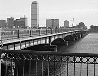
The bridge as seen from Cambridge in 1985. The signs of wear and tear and the barriers on the outer lanes are clearly visible.
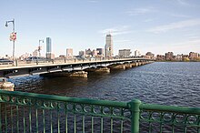
Much the same view in 2009.

The bottom of the bridge in 1985.

The same picture in 2009. The added longitudinal members can be seen in particular.
.jpg)


Measure the length of the bridge

The length of the Harvard Bridge is also measured in the idiosyncratic unit of smoot . This goes back to the year 1958 where some members of the MIT - fraternity Lambda Chi Alpha measured the length of the eastern sidewalk of the bridge by the smallest new addition this year, a certain Oliver R. Smoot , carried from one end to another, or pulled. 1 Smoot corresponds to his height of 67 in (1.7 m ). Ironically, Oliver Smoot later became President of the International Organization for Standardization (ISO).
Since then, passers-by are at intervals of 10 Smoot informed applied marks the fact that the length of the bridge 364.4 Smoot (/ plus minus an ear) is. A certain measurement error is supposed to be expressed scientifically correct. Over the years, however, the negative deviation from the quotations disappeared, as did most of the markings on the bridge. Today the markings are redrawn twice a year by members of the fraternity.
During the renovation of the superstructure in the 1980s, the markings were also transferred to the new surface of the eastern sidewalk, with the express permission of the authorities. The length of the slabs for the sidewalks was also specified in Smoot instead of the usual 6 ft (1.8 m ) . Today, the Cambridge police use these markings as location information when reporting accidents on the bridge.

See also
Individual evidence
- ↑ a b c d e f Harvard Bridge. at bridgehunter.com, accessed October 29, 2012 .
- ↑ a b c Harvard Bridge. In: nationalbridges.com. Retrieved October 29, 2012 .
- ↑ a b c d e f g h i j k l m n o Department of the Interior (Ed.): Harvard Bridge, Spanning Charles River at Massachusetts Avenue, Boston, Suffolk County, MA (= Historic American Engineering Record (HAER) ). Philadelphia, Pennsylvania 1987 ( entry on the Library of Congress [accessed October 30, 2012]).
- ↑ a b Andy Kostoulas: This Month In History MIT . In: MIT (ed.): The Tech . Volume 119, Issue 49. Cambridge, Massachusetts October 12, 1999, OCLC 60637439 ( tech.mit.edu [accessed October 30, 2012]).
- ↑ a b c d e f g h i j k Verne L. Roberts: Harvard Bridge . Boston to Cambridge, March 1892. Ed .: Massachusetts Commissioners on Harvard Bridge. Rockwell and Churchill, Boston 1892, OCLC 1628531 ( online in Google book search).
- ↑ Recent Deaths. In: Boston Evening Transcript. Boston Transcript Company, February 16, 1891, accessed October 30, 2012 : “Mr. Leander Greeley, a prominent master builder of Boston and Cambridge and one of the three Harvard Bridge Commissioners, died this morning. "
- ^ John Harvard Facts. In: Encyclopedia of World Biography. 2004, accessed October 31, 2012 .
- ^ The Campus. MIT , accessed October 31, 2012 .
- ↑ Johanna Kaiser: Mass. Ave, BU Bridge bike lanes completed. In: The Boston Globe . January 6, 2012, accessed October 31, 2012 .
- ^ Julia Boulton Clinger: It happened in Boston . TwoDot, Guilford, Conn. 2007, ISBN 978-0-7627-4134-2 , pp. 61–63 ( online in Google Book Search).
- ↑ Famous Harvard Bridge Unsafe. (PDF) In: The New York Times . July 16, 1909, accessed October 31, 2012 .
- ^ Commonwealth Begins Work on Harvard Bridge. (PDF; 200 kB) In: The Tech. MIT , October 3, 1924, accessed October 31, 2012 .
- ^ A b Kenneth M. Leet: The Harvard Bridge . Phase II report. Ed .: Metropolitan District Commission, Parks Engineering Division. Metropolitan District Commission, Boston 1972, OCLC 13032102 .
- ^ A b c Kenneth M. Leet: An investigation of the Harvard Bridge . Final report phase III. Ed .: Metropolitan District Commission, Parks Engineering Division. Metropolitan District Commission, Boston 1972, OCLC 13032110 .
- ^ Tom Keane: It's the Engineering, Stupid. In: The Boston Globe . June 10, 2006, accessed November 1, 2012 .
- ↑ United Press International : AROUND THE NATION; Boston's Harvard Bridge Closed to Heavy Trucks. In: The New York Times . July 6, 1983, accessed November 1, 2012 .
- ^ A b United States Federal Highway Administration, Massachusetts Dept. of Public Works (Ed.): Harvard Bridge / Massachusetts Avenue Bridge over the Charles River . bridge replacement project, Boston / Cambridge, Massachusetts. The Administration, Washington, DC 1986, OCLC 15174492 .
- ↑ Ronald Rosenberg: MASS. AVE. BRIDGE TO REOPEN FOUR LANES AFTER SEVEN YEARS. In: The Boston Globe . September 12, 1990, accessed November 1, 2012 (English, paid article).
- ↑ Robert Tavernor: Smoot's Ear: the measure of humanity . Yale University Press, New Haven, London 2007, ISBN 978-0-300-12492-7 .
- ↑ Smoot in stone. In: MIT News. MIT , June 4, 2009, accessed November 1, 2012 .
- ↑ David A. Fahrenthold: The Measure of This Man Is in the Smoot. MIT's Human Yardstick Honored for Work. In: The Washington Post . December 8, 2005, accessed November 1, 2012 .
- ↑ Denise Brehm: Keyser describes his top five hacks. In: MIT News. MIT , September 1, 1999, accessed November 1, 2012 .
Web links
- Harvard Bridge in the United States Geological Survey's Geographic Names Information System
- Harvard Bridge. In: Structurae
|
Upstream Boston University Bridge MA 2 |
Crossing the Charles River Harvard Bridge MA 2A |
Downstream Longfellow Bridge MA 3 |