Huntington Avenue
| Huntington Avenue | |
|---|---|
| Street in Boston | |
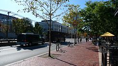
| The Huntington Avenue in 2009 | |
| Basic data | |
| place | Boston |
| District | Back Bay , Fenway-Kenmore , Longwood , Mission Hill |
| Connecting roads | Washington Street , Dartmouth Street |
| Cross streets | Riverway , Jamaicaway , Tremont Street , Massachusetts Avenue , Massachusetts Turnpike |
| Places | Olmsted Park , Copley Square |
| Buildings | Harvard Medical School , Harvard School of Public Health , Massachusetts College of Art and Design , Museum of Fine Arts , Northeastern University |
| use | |
| User groups | Pedestrian traffic , bicycle traffic , motor traffic , public transport |
| Technical specifications | |
| Street length | 2.3 mi (3.7 km ) |
The Huntington Avenue is a 2.3 mi (3.7 km) of road in Boston in the state of Massachusetts of the United States . It is consistently designated as Massachusetts Route 9 and runs essentially from southwest to northeast.
Route
The street begins in the west at the transition to Washington Street near Olmsted Park and after a few meters it crosses under the Riverway and the Jamaicaway , which run in opposite directions at this point and cross the same bridge. From the junction with Tremont Street , Huntington Avenue is separated by a median strip on which the Green Line E tracks run.
It continues along the eastern border of the Longwood Medical and Academic Area and past the Massachusetts College of Art and Design and the Museum of Fine Arts . Northeastern University is also on the road. After crossing Massachusetts Avenue and passing under the Massachusetts Turnpike , the route ends in Copley Square at the intersection with Dartmouth Street .
Individual evidence
- ↑ Determined in Google Maps .
Web links
- Street Book. City of Boston, accessed January 18, 2013 .
Coordinates: 42 ° 20 '18.6 " N , 71 ° 5' 37.7" W.
