Alewife Brook Reservation
|
Alewife Brook Reservation
|
||
|
A small river flows through the reserve |
||
| location | Cambridge , Arlington and Somerville , Massachusetts , United States | |
| surface | 48.56 hectares | |
| Geographical location | 42 ° 24 ' N , 71 ° 9' W | |
|
|
||
| Setup date | 1906 | |
| Framework plan | Metropolitan Park System of Greater Boston | |
| administration | Massachusetts Department of Conservation and Recreation | |
The Alewife Brook Reservation is a designated state park in the area of the cities of Cambridge , Arlington and Somerville in the state of Massachusetts in the United States . The park is administered by the Department of Conservation and Recreation (DCR) and is part of the Metropolitan Park System of Greater Boston .
description
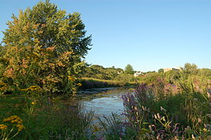
The reserve covers 200 acres (0.8 km² ) of urban wilderness . Much of the park consists of wetlands (including the Little River ), but there are also wooded highlands and meadows. The reserve is a habitat for a wide variety of native and migratory birds . Frequently occurring species are ospreys , great blue herons and also snipes , whose unusual courtship ritual can be observed by visitors. The ponds Little Pond and Blair Pond are in the spring, the nursery for herring , by the Atlantic Ocean on the Mystic River and Alewife Brook , in turn, the Little River drained, hiking .
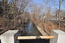
The southern end of the reserve is in the immediate vicinity of the MBTA Alewife station at the northern end of the Red Line in Cambridge . The Minuteman Bikeway ends at the reservation, while the Fitchburg Cutoff Path and Alewife Greenway pass through the area. The Alewife Brook flows north through Cambridge , Arlington and Somerville to the Mystic River . For much of the route, the area is relatively narrow and only includes the river, Alewife Brook Parkway, and a few strips of land on either side. To the north of Broadway , the area between the river and the parkway opens up and offers several sports and playgrounds . There are cycling and hiking trails along the river, which are continuously being improved and expanded as part of the Alewife Greenway project.
history
In 1843, the main line of the Fitchburg Railroad was the first railway line to pass through the wetland in western Cambridge. Today the route of the Fitchburg Line is used for the transport of commuter trains. As a branch of the Fitchburg Railroad , the Lexington and West Cambridge Railroad was founded in 1846 , the tracks of which are still partially visible today. In 1851, the Watertown Branch Railroad was added, which branched off from Fitchburg and passed along the eastern side of Alewife Brook Parkway .
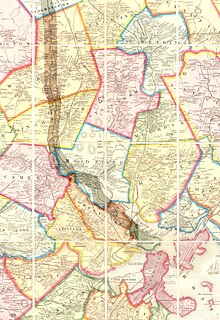
The Boston and Lowell Railroad bought the former Lexington and West Cambridge Railroad in 1870 , which at that time was already called Lexington and Arlington Railroad , and built a connection from Alewife via present-day Davis Square to Somerville Junction . Most of this link is now covered by the Somerville Community Path and Alewife Linear Park . A map from 1903, i.e. from the time before the designation as a protected area, shows the various railway lines in the area as well as the Alewife Brook , which drains the Fresh Pond further south .

The reserve was originally designed jointly with Alewife Brook Parkway by landscape architect Charles Eliot , but has changed significantly over time. Thus the river was straightened and channeled alongside the Parkway from 1909 to 1912. In 1916 the construction of the road was completed. The landscape work was carried out by the Olmsted Brothers .
Wetlands
In 2011, the City of Cambridge began building a 3.4 acres (13,750 m²) rainwater retention basin west of Alewife Station , which is designed as a wetland . Together with the plants that have settled there, the basin is intended to reduce the flow speed of the water and remove pollutants and nutrients from it before it reaches the Little River . Completion is scheduled for spring 2013. At this point in time, the connection of the cycle paths as well as the construction of an amphitheater and the installation of signage and footpaths are planned. Different habitats from deep marshland to alluvial forest are also planned.
The Alewife Brook Greenway
A project for the construction of a cycle path in the protected area received 4.5 million dollars from the American Recovery and Reinvestment Act . The Alewife Brook Greenway or Minuteman Bike Path connector connects the Mystic River Bike Path with the Minuteman Bikeway and the Alewife Station .
Recreational and leisure activities
In the park there are sports and playgrounds , otherwise you can walk , run and birdwatching pursue.
Individual evidence
- ^ Commonwealth of Massachusetts (Ed.): Private and special statutes of the commonwealth of Massachusetts . tape 20 . Manning & Loring, Boston 1909, OCLC 183313361 , p. 293 ( limited preview in Google Book search).
- ↑ 1903 Alewife Brook map. Friends of Alewife Reservation (FAR), January 7, 2005, accessed June 18, 2012 .
- ↑ Local map. University of New Hampshire, accessed June 18, 2012 .
- ↑ Major Progress in Alewife Reservation Stormwater Wetland Construction. (No longer available online.) City of Cambridge, MA, December 19, 2011, archived from the original on January 5, 2012 ; accessed on June 18, 2012 (English).
- ↑ Project Summary: ARLINGTON- CAMBRIDGE- SOMERVILLE- ALEWIFE GREENWAY CORRIDOR RESTORATION . Archived from the original on July 26, 2011. Retrieved September 5, 2010.
- ^ Alewife Brook Greenway Corridor Improvement Project. (No longer available online.) Town of Arlington, archived from the original on July 21, 2012 ; accessed on June 18, 2012 (English).
Web links
- Official website
- Friends of Alewife Reservation website
- Real Time Water Quality Monitoring Website. (No longer available online.) Archived from the original on May 14, 2008 ; accessed on August 9, 2012 .


