Boston South Station
| Boston South Station | |
|---|---|

|
|
| Data | |
| Design | Terminus |
| Platform tracks | 13 (7 platforms) |
| abbreviation | BOS |
| opening | 1899/1985 |
| Website URL | Homepage |
| Architectural data | |
| Architectural style | Revolutionary architecture |
| architect | Shepley, Rutan, & Coolidge; Norcross bros. |
| location | |
| City / municipality | Boston |
| State | Massachusetts |
| Country | United States |
| Coordinates | 42 ° 21 ′ 7 ″ N , 71 ° 3 ′ 19 ″ W |
| List of train stations in the United States | |
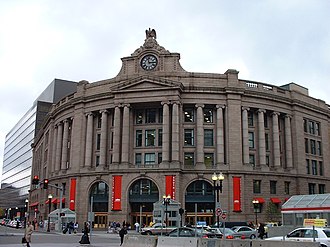
The train station Boston South Station (distributed only South Station called) is located at Dewey Square of the roads at the crossing Atlantic Avenue and Summer Street in Boston in the state of Massachusetts of the United States . Directly after Logan International Airport, it is the second largest transport hub in New England and also the largest train and bus station in the entire Greater Boston metropolitan area . The station complex also includes a subway station of the same name owned by the Massachusetts Bay Transportation Authority with a connection to the Red Line subway and the Silver Line bus rapid transit line .
history
Consolidation of several terminal stations
At the time of its construction, each of the railways in Boston stopped at its own terminus . The four stations that served the railway lines to the south were
- a building east of Dewey Square at the north end of what is now South Station , where trains of the New York and New England Railroad stopped, which had crossed the Fort Point Channel from South Boston ,
- an elongated passenger station of the Old Colony Railroad on the east side of South Street , which stretched from Kneeland Street to Harvard Street and which is now part of the South Bay Interchange ,
- a Boston and Albany Railroad station within the block formed by Kneeland Street , Beach Street , Albany Street and Lincoln Street in what is now Chinatown as well
- a station on the Boston and Providence Railroad in Park Square .
The Boston Terminal Company was founded in 1897 to combine these four terminus stations into one building . This concept of integrating multiple rail companies into a single station building is known as Union Station , and many stations in North America also bear this name explicitly.
- The Boston Railroad and Atlantic Avenue Elevated
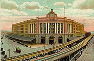
The Atlantic Avenue Elevated in front of the South Station , view from the early 1900s
Early development
The South Station opened on January 1, 1899 under the name South Central Station . The construction of the new station had cost 3.6 million US dollars , which in 2011 was equivalent to between $ 86.3 million and $ 2.79 billion - depending on the calculation. The Boston architecture firm Shepley, Rutan and Coolidge was responsible for the construction, with Westinghouse, Church, Kerr & Co taking over the construction work .
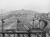
Atlantic Avenue Elevated stopped at the station from 1901 to 1938 , and in 1913 the route of the predecessor of today's Red Line was extended from Park Street Station to South Station . The station's engine shed , which was originally one of the largest in the world, was demolished in 1930 due to corrosion damage caused by the salty sea air .
During the Second World War , the station was used by 125,000 passengers daily, but rail traffic declined significantly after the end of the war. In 1959 the Old Colony Railroad , which had served the Cape Cod and South Shore regions , ceased operations, followed by the bankruptcy of the New York, New Haven and Hartford Railroad in 1961 . The station building was sold to the Boston Redevelopment Authority (BRA) in 1965 , which had it partially demolished to make way for the Boston South Postal Annex and the Stone and Webster building.
Originally, an underground level with a double-track loop was planned, which was built but never put into service. Instead, a parking garage and a bowling alley for employees of the station were set up there in later years .
Renovations
In 1978 the station building, which had meanwhile been recorded on February 13, 1975 under the number 75000299 in the National Register of Historic Places , was sold to the Massachusetts Bay Transportation Authority . However, the BRA retained the rights to the airspace over the station. The new owner provided short term funding of $ 195 million for extensive renovations that were completed in 1989. Since then, a total of 13 tracks have been available, all of which have raised platforms for barrier-free access and some are long enough for trains with 12 wagons. Piers were installed to support an office building to be built later and a bus station above the tracks. The bus station opened late in October 1995 and replaced the previously used terminal on the roof of the Dewey Square Tunnel diagonally across from South Station . In 1985, the platforms of the Red Line were extended to serve trains with 6 wagons. Another renovation followed in 2005 as part of phase 2 of the Silver Line project in conjunction with the construction work on Big Dig .
Passenger numbers
At the time of its construction at the end of the 19th century, the South Station had very high passenger numbers due to its central importance for commuters. However, massive cuts in the New Haven Railroad , which later became insolvent, led, in conjunction with the ever increasing importance of the automobile, to a considerable decline in passenger numbers.
In the recent past, more passengers have been counted, which is attributed, among other things, to the reopening of the train lines of the Old Colony Railroad and the electrification of the Northeast Corridor and the associated commissioning of the Acela Express .
| Area | Passengers per year | ||
|---|---|---|---|
| 1975 | 1990 | 2001 | |
| Long-distance rail | 537,000 | 839,000 | 1,060,000 |
| Commuter trains | 2,774,000 | 12,000,000 | 18,000,000 |
| Long-distance bus transport | / | / | 3,000,000 |
Railway systems
Track, signal and security systems
The station has 13 tracks, which are connected via 7 platforms .
building
The entire station building is barrier-free . Several elevators are available for access to the subway. The station is open 24 hours a day, every day of the year.
Inside the building there is a work of the Museum of Science , which depicts the planet Jupiter , as well as a sculpture consisting of old couplings as art in public space .
architecture
The above-ground building of Boston South Station and its wings were built in the style of revolutionary architecture. In particular, the geometric symmetry of the building and the stone facade clearly indicate this style. The granite required was extracted from nearby quarries in New England . The main entrance is in a section that protrudes from the convex contour of the building. The entrance doors are covered by high arches that give an impression of grandeur, but at the same time make the building appear smaller from a distance. This optical trick, typical of the architectural style, is further emphasized by the oversized windows and sweeping balustrades on the third floor and on the roof.
Above the entrances there are classic columns in an ionic order , which visually support the frieze and the gable . What is unusual for columns in an ionic order is the lack of fluting , which normally draws attention upwards and thus further enhances the splendor of the facade. The large number of elevations and depressions on the facade contribute to the first-class quality of the building and at the same time generate interesting light and shadow gradients outside and inside the building. The roof over the tracks is decorated with a coffered ceiling.
Constructed over 100 years ago on top of the main building, the clock is the largest hand-wound clock still in operation in New England . It was built on the model of London's Big Ben and has a dial with a diameter of 12 ft (3.7 m ). The weight of the movement is more than 180 kg. In 2008 the watch underwent a six-week restoration and repair, during which the movement was completely dismantled and transported to a nearby workshop, where necessary spare parts had to be made by hand. The watch is a hallmark of a bygone era that reminds visitors of it and which commuters still rely on every day. The eagle perched on her weighs more than eight tons and is 8 ft (2.4 m) tall. He imitates the figures that are often found on buildings of this architectural style.
The curved contour of the building clearly sets it apart from the surrounding structures and thus ensures significantly greater visibility. In addition, the area of the main entrance on Atlantic Avenue and Summer Street and on Dewey Square could be optimally designed. An analogous concept can also be found in the Church of Santa Maria della Pace in Rome . Although it did not directly influence the design of the South Station , the designs have the same effects on the immediate surroundings of the buildings.
In the 1980s, with the help of federal funds, a large-scale revitalization of the building, which was in poor condition at the time, began. This included, among other things, the construction of two wings of the building, which for optical reasons were built from the same granite as the main building. The construction work was completed in 1989. A short time later, construction of new office buildings began in the neighborhood, which further expanded the city center. With the completion of the Big Dig and the Rose Kennedy Greenway , the station's importance as a transportation hub increased even further. The grass verge provides pedestrians with easy access between South Station and North Station .
Metro station of the MBTA
The metro station South Station (also South Station Under ) is located at the train station South Station , providing access to the metro line Red Line of the MBTA and the Bus Rapid Transit system of the Silver Line .
The underground station has two tracks, each of which is accessible via a side platform . There are also three additional bus platforms available for the Silver Line buses . The station was opened for the Red Line on December 3, 1916, and the connection to the Silver Line was added on December 17, 2004. On an average working day , 22,632 passengers use the subway station.
| Previous station | MBTA | Next station | ||
|---|---|---|---|---|
|
Downtown Crossing towards Alewife |
Red Line |
Broadway towards Ashmont / Braintree |
||
| final destination |
Silver Line SL 1 |
Courthouse towards Logan International Airport |
||
| final destination |
Silver Line SL 2 |
Courthouse towards the Design Center |
||
|
Tufts Medical Center towards Dudley Square |
Silver Line SL 4 |
final destination | ||
Bus station of the MBTA
The MBTA's South Station Bus Terminal, which was built in the 1990s and is connected to the station, was built above the platforms along Atlantic Avenue and is the largest Boston hub for long-distance bus connections from various operating companies, including the MBTA itself. The area covered includes all of New England , New York City , the Mid-Atlantic Coast and Montreal in Canada . The five-story building can be entered via Platform 1 of the station or via entrances on Atlantic Avenue .
Analogous to the history of the origin of the train station, the new bus station represented a single point of contact for a large number of bus companies that previously operated a large number of their own terminals all over Boston. The abandoned predecessor buildings include the former bus station on Dewey Square , the Greyhound Lines terminal in the Back Bay district and several smaller bus stations in Chinatown .
Connection connections
Since many lines of the MBTA Commuter Rail and the Downeaster to Maine depart from Boston North Station, about 1.25 mi (2 km ) away, and there is no direct rail link between the two stations, travelers must either walk or walk along the Rose Kennedy Greenway use public transport. For example, the Red Line can be taken one station in the direction of Alewife . At the Downtown Crossing station there is a change to either the Orange Line in the direction of Oak Grove or the Green Line C with terminus Boston North Station . Fitchburg Line passengers can also take the Red Line to Porter , where they can transfer directly to the Commuter Rail train.
The South Station is located at the northern end of the Northeast Corridor of Amtrak and is therefore, among other things, the terminus of the Acela Express and trains of the Northeast Regional . Amtrak also offers daily connections to Albany , New York and Chicago , Illinois , with Lake Shore Limited .
The Massachusetts Bay Transportation Authority (MBTA) uses the station as the terminus for the western and southern Commuter Rail routes, as a stop on the Red Line subway line, and as the terminus for several branches of the Silver Line .
environment
In the vicinity of the train station are
- the Boston South Postal Annex with a post office that is open non-stop (passage from platform 13),
- the districts of Chinatown and Financial District with the Federal Reserve Bank Building ,
- the Boston Children's Museum ,
- the ships and museum for the Boston Tea Party ,
- the Boston Convention and Exhibition Center
- the Boston Harborwalk ,
- the Boston Theater District ,
- the Massachusetts Turnpike ,
- the Institute of Contemporary Art, Boston ,
- the Rose Kennedy Greenway ,
- the medical campus of Tufts University with the Tufts Medical Center as well
- the Rowes Wharf ferry terminal .
outlook
As a result of improvements in rail and other public transport systems, the number of passengers using South Station will continue to increase in the future as it is a central hub. The existing stations of the Red Line and Silver Line still have sufficient reserves, but the platforms of the MBTA Commuter Rail and Amtrak are already reaching their capacity limits.
There are therefore considerations to relocate the building of the Boston General Mail adjoining the railroad station tracks to a new location so that an expansion of the South Station becomes possible. A total of seven new tracks could be installed in this way, which would then be available to both the commuter lines and the Amtrak.
In October 2010, the state of Massachusetts received $ 32.5 million in funding from the US federal government to begin planning its expansion. After extensive deliberation, a $ 43 million contract (of which $ 10.5 million from federal funds) was signed in 2012.
See also
Individual evidence
- ^ South Station. (No longer available online.) Project for Public Spaces, archived from the original on June 24, 2013 ; accessed on March 11, 2013 (English). Info: The archive link was inserted automatically and has not yet been checked. Please check the original and archive link according to the instructions and then remove this notice.
- ^ Measuring Worth. Retrieved March 12, 2013 .
- ↑ Razing Rail Depot tests skill of Engineers . In: Popular Mechanics . No. 39 , December 1930, p. 958 ff . ( limited preview in Google Book search).
- ^ Boston - South Station, MA (BOS). The Great American Stations, accessed March 12, 2013 .
- ^ South Station. (No longer available online.) In: southstation.org. Archived from the original on July 17, 2012 ; accessed on March 12, 2013 . Info: The archive link was inserted automatically and has not yet been checked. Please check the original and archive link according to the instructions and then remove this notice.
- ↑ entry South Station Head House National Register Information System . National Park Service , accessed May 13, 2017
- ↑ PATRICK-MURRAY ADMINISTRATION, MAYOR MENINO LAUNCH SILVER LINE DIRECT CONNECT SERVICE TO SOUTH STATION. Massachusetts Bay Transportation Authority , October 13, 2009; accessed March 13, 2013 .
- ↑ Alexander French, William Fowler: The Renovation of Boston's South Station. (PDF; 1.4 MB) Massachusetts Institute of Technology , May 19, 2003, accessed March 15, 2013 .
- ^ Ridership and Service Statistics. (PDF; 6.2 MB) Thirteenth Edition 2010. Massachusetts Bay Transportation Authority , 2010, accessed on March 15, 2013 .
- ^ Casey Ross, Noah Bierman: State wants postal land. A push to save rail expansion; funds for deal in question. In: The Boston Globe . January 8, 2010, accessed March 15, 2013 .
- ↑ Associated Press : Mass. receives funds to upgrade South Station. In: The Boston Globe . October 25, 2010, accessed March 15, 2013 .
- ↑ Martin Finucane: State wins $ 32.5M grant to plan South Station expansion. In: The Boston Globe . October 25, 2010, accessed March 15, 2013 .
- ^ Matt Rocheleau: State to soon launch $ 43m planning effort for project to expand South Station. In: The Boston Globe . August 20, 2012, accessed March 15, 2013 .
literature
- History of the station. South Station LLC, accessed March 15, 2013 .
- Amanda Sorrento: Boston South Station. Foundations of America, November 4, 2010, accessed March 15, 2013 .
- South Station. Project for Public Spaces, accessed March 15, 2013 .
- Noah Bierman: Station clock takes timeout. Watch this: 110-year-old mechanism set for an overhaul. In: The Boston Globe . October 15, 2008, accessed March 15, 2013 .
Web links
- Official website
- MBTA - Boston South Station
- Boston South Amtrak Station - (USA RailGuide - TrainWeb)
| Previous station | MBTA | Next station | ||
|---|---|---|---|---|
|
Back Bay towards Worcester Union Station |
MBTA Commuter Rail Framingham / Worcester Line |
final destination | ||
|
Back Bay towards Needham Heights |
MBTA Commuter Rail Needham Line |
final destination | ||
|
Back Bay towards Forge Park / 495 Occasional Foxboro |
MBTA Commuter Rail Franklin Line |
final destination | ||
|
Back Bay towards Wickford Junction |
MBTA Commuter Rail Providence / Stoughton Line |
final destination | ||
|
Uphams Corner towards Readville |
MBTA Commuter Rail Fairmount Line |
final destination | ||
| final destination | CapeFLYER |
JFK / UMass direction Hyannis |
||
| final destination |
MBTA Commuter Rail Greenbush Line |
JFK / UMass towards Greenbush |
||
| final destination |
MBTA Commuter Rail Middleborough / Lakeville Line |
JFK / UMass towards Middleborough / Lakeville |
||
| final destination |
MBTA Commuter Rail Plymouth / Kingston Line |
JFK / UMass towards Plymouth / Kingston |
||


