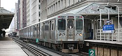
Chicago Elevated
| The "L" | |
|---|---|

|
|
| operator | Chicago Transit Authority (CTA) |
| Lines | 16 |
| Route length | 171 km |
| Gauge | 1435 mm |
| Stations | 144 |
| Employee | |
| Passengers / year | 150 million (2006) |
| vehicles | 2200, 2400, 2600, 3200, 5000 |
| Website | www.transitchicago.com/ |
The Chicago Elevated is the elevated and subway of Chicago , USA .
Surname
Chicago Elevated (Railroad) can be translated as " Chicago Elevated Railway". Colloquially, the Chicago Elevated is referred to as Chicago El , Chicago L , El or L , among others . In official parlance it is called L , respectively. This also applies to the parts of the network that run at ground level or in tunnels.
history
The oldest network sections of the "L" date from 1892. In 1893 a branch line to the World Columbian Exposition was built, on which the "Intramural Railway" called the world's first electrically operated elevated railway.
1924 was created through the merger of several privately owned railways, the Chicago and South Side Rapid Transit Co. (founded: 1892), the Lake Street Elevated Railroad Co. (1893), the Metropolitan West Side Elevated Railroad Co. (1895) and the Northwestern Elevated Railroad Co. (1900) the Chicago Rapid Transit Company (CRT). Their network formed the basis of the network operated today by the Chicago Transit Authority (CTA), which was further expanded.
Route network
The route network for regular services has a length of 106.1 miles (170.8 km). Of these, 57.1 miles (91.9 km) are elevated , 36.9 miles (59 km) at ground level and 12.1 miles (19.5 km) in tunnels. The total length of the network - including all operational lines and facilities that are not used in regular service - is 222 miles (357 km). The route network includes Chicago, Evanston , Skokie , Wilmette , Rosemont , Forest Park , Oak Park and Cicero . It has 144 passenger stations, 17 of which offer park-and-ride facilities with a total of 6639 parking spaces.
A special feature of the network is the "loop", an elevated railway ring, the center of the line network. It runs as a ring line at a height of about eight meters above streets and surrounds the core of downtown Chicago. A rarity is the level crossing of two double-track lines at the north-west corner of the “loop” with numerous connecting switches in a very small space, which enable the route to be changed in three directions and to the track in the opposite direction.
Another special feature on the Blue and Red Lines are within the “loop” in the city center, stations with overlong platforms, where the trains stop several times in a row and each stop is its own station. The Red Line platform is between Lake and Jackson stations . Between the two is the additional stop Monroe . The common platform of the three stations is 3500 ft (approx. 1050 m) longer than that of the Blue Line with 2500 ft (approx. 750 m). This stretches from Washington to Jackson and also includes another stop, Monroe . According to the Guinness Book of Records, the platform on the Red Line is the longest subway platform in the world. The areas of these long platforms are less lit outside the stations and hardly have any exits.
Along the highways that radiate from Chicago into the surrounding area, the "L" drives on routes between the lanes for both directions. Chicago pioneered the use of the central reservation for light rail routes in the 1950s .
Lines
|
Chicago 'L' |
|
| Red Line | |
| Orange line | |
| Yellow line | |
| Green Line | |
| Blue line | |
| Purple line | |
| Brown Line | |
| Pink Line | |
The "L" operates eight lines, each of which is labeled in its own color for identification. Seven of the lines connect downtown with suburbs and communities in the greater Chicago area. The Violette Line only runs to the city center during peak times . The Yellow Line, on the other hand, serves a branch line from Howard Station to Skokie. From the other lines, all except the red and blue lines use the “loop”. The red and blue lines, on the other hand, cross the city center within the “loop” as a subway.
All train stations are manned by at least one customer advisor , but tickets are only available from ticket machines .
Chicago is one of the few American cities in which two major airports can be reached by rail. The Blue Line travels from downtown to Chicago O'Hare Airport in 40 minutes , and the Orange Line to Chicago Midway Airport in half an hour .
meaning
The “Chicago-L” is one of the busiest traffic systems in the USA. According to statistics from 2003, 494,743 people used the "L" every day on weekdays, 262,791 people on Saturdays and 180,951 people on Sundays. This corresponds to a number of passengers of 150 million per year. Despite its prominence in the cityscape, the "L" is not the most widely used means of public transport in Chicago. This is the bus system of the CTA, which connects all surrounding places with Chicago with 148 lines.


