Chief Roi Mata's Domain
| Chief Roi Mata's Domain | |
|---|---|
|
UNESCO world heritage |
|

|
|
| Location of Chief Roi Mata's Domain on the north coast of Efate |
|
| National territory: |
|
| Type: | Culture |
| Criteria : | iii, v, vi |
| Reference No .: | 1280 |
| UNESCO region : | Asia and Pacific |
| History of enrollment | |
| Enrollment: | 2008 (session 32) |

Chief Roi Mata's Domain is the title of a World Heritage Site of UNESCO in the Pacific island nation of Vanuatu . It covers the territory of the Supreme Chief, Chief Roi Mata, on the northwest coast of the island of Efate . In 2008, Chief Roi Mata's Domain, together with the archaeological site of the Historical Agricultural Landscape of Kuk in Papua New Guinea, was the first World Heritage Site in an independent Pacific island nation.
background
Chief Roi Mata is the name of a chief, but also the title used by all members of his dynasty. In particular, it refers to the last bearer of the title, who died around the end of the 16th century or the beginning of the 17th century. It is associated with the pacification of the region after a long period of wars and the introduction of a matrilineal clan system.
Roi Mata was a supreme chief, on whom other, lower chiefs were dependent in a feudal pyramid. These formed a court and were entrusted with the care of individual parts of the territory. Land rule is not to be understood in the European sense, but rather as fiduciary administration for the benefit of future use by the community. Many of the rulership titles used today in north-western Efate and on the Shepherd Islands are said to have been donated by Roi Mata.
The dominion included an area of the northwest coast of Efate from Cape Tukutuku to the island of Lelepa and the offshore islands of Lelepa and Eretoka . Around 670 people live in this area today, most of them in the villages of Mangaliliu on Efate and Natapau on Lelepa.
Protected sites
For the definition of the World Heritage Site, the domain was described as “all the land that is visible from the highest point of Eretoka” , an area of 12.75 square kilometers including the sea in between. In particular, however, are protected
- Mangaas , the former residence of Roi Mata, now abandoned,
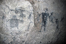
- Fels Cave , acaverichly decorated with rock paintings on Lelepa , in which, according to legend, Roi Mata died,
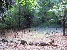
- Eretoka (Artok), the entire island on which the burial place of Roi Mata is and
- the sea area between these three points.
The first three places are all traditionally protected by religious prohibitions ( tapu ) of various kinds. After the death of the last chief, Roi Mata, the settlement of Mangaas was abandoned, and since then there has been no agriculture in the immediate vicinity. Agriculture is also prohibited on the burial island of Eretoka, which had also been settled before, and the construction of permanent housing and overnight stays on the island are prohibited. Fels Cave is considered a sacred place where the souls of the dead reside.
tourism
The village communities of Mangaliliu and Natapau, with the support of the National Museum of Vanuatu, offer a day tour Roi Mata Cultural Tour , during which interested visitors can get information about Chief Roi Mata and visit the various sites.
Web links
- Entry on the UNESCO World Heritage Center website ( English and French ).
- Nomination documents (PDF, 43 MB!) Of the Republic of Vanuatu for the entry of Chief Roi Mata's Domain in the World Heritage List, 2006/07 (English)
- Roi Mata Cultural Tour on the Vanuatu National Museum side
Coordinates: 17 ° 38 ′ S , 168 ° 11 ′ E
