Eretoka
| Eretoka | ||
|---|---|---|
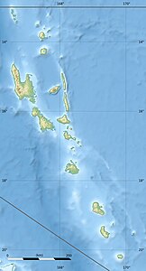
| Location of Eretoka on the northwest coast of Efate | ||
| Waters | Pacific Ocean | |
| Archipelago | New Hebrides | |
| Geographical location | 17 ° 38 '40 " S , 168 ° 9' 10" O | |
|
|
||
| length | 2.3 km | |
| Residents | uninhabited | |
| View of Eretoka from Lelepa | ||
Eretoka (also Érétoka , Retoka or Artok ) is an uninhabited island in the southwestern Pacific island state of Vanuatu and belongs to the New Hebrides archipelago . It is off the northwest coast of the island of Efate . Because of its striking silhouette, the first European visitors called it Hat Island ( Hat Island ).
Eretoka extends 2.3 kilometers in a northeast-southwest direction and has a maximum width of 670 meters. The center of the island is formed by a cap of coral limestone over stratified pumice stone and is 90 meters high. Around the island there is a wide and flat area of sand and limestone, which was lifted above the surface of the water when the seabed was last raised. Most of this area is no higher than five meters above sea level.
The burial place of the highest chief Roi Mata, who died at the end of the 16th century, is located on the island . Since 2008, the entire island as part of is Chief Roi Mata's Domain is a world heritage of UNESCO .
history
Eretoka was settled in earlier times. Ceramic finds show that it was used intensively as early as 2,400 years ago. About 900 years old are sherds whose origin refers to the Shepherd Islands in the north . The remains of coral dry stone walls can be found on the island. These form an extensive system of garden and house plots that includes almost all flat and not too low-lying areas on the island.
According to oral tradition, the first chief known as Chief Roi Mata (Roi Mata is a name and a title for all members of the dynasty) immigrated to Efate from the south about a thousand years ago. He settled on the northwest coast and appointed a number of subordinate chiefs. Not only did they live in northwest Efate, but they also moved to the Shepherd Islands before they were driven back by the volcanic eruption of Kuwae in 1452. At that time, the now abandoned settlement of Mangaas , opposite the island of Lelepa on the coast of Efate, was the residence of Chief Roi Mata. His immediate area of influence extended from Tukutuku Bay in the west to Lelepa.
During this time, Eretoka was owned by a clan called Alpak, who mainly settled on Lelepa. When the last bearer of the title Roi Mata died around 1600, his family bought the island in a land swap for his burial. This practice was unusual because chiefs are usually buried on their home grounds. For fear of his special powers, a place was chosen instead that was visible from his entire territory, but was at a sufficient distance from every settlement.
After the funeral, Eretoka was declared a tapu . Since then it has been forbidden to farm and stay overnight there. The island has been largely left to its own devices for four hundred years, up to the present.
With the arrival of the European colonialists on Vanuatu, the understanding of land ownership changed. Traditionally there are no individual owners, only trustees with responsibility to the community. The French and English authorities, however, allowed land to be leased to foreign buyers. Many chiefs made use of it as a source of income, and in 1871 Eretoka was also leased to an Englishman. The island then passed through many different hands, but no one seems to have ever shown any substantial interest in using it.
It wasn't until the 1960s that a tenant named Ernie Reid built a small hunting lodge and released a few goats. But he never lived on the island, only went on hunting and fishing trips there. The construction of the permanent hut aroused the indignation of the locals. Reid erected a beacon on the high part of the island, but it has long since fallen into disrepair.
In 1965 the burial ground of Roi Mata was placed under protection by the colonial government as a "site of historical interest" - the only application of this law to the New Hebrides during the entire colonial period.
In 1975 the lease expired. After Vanuatu's independence in 1980, the island returned to common law, and Chief Meto Kalotiti is still responsible today. He leased the island again to an Australian investor in 1994 for a term of 75 years. This happened against the resistance of the provincial government, the chief council, the national museum and most of the local population. Ultimately, however, the basic office confirmed the contract. Since the promised development of a holiday complex on the island had not been tackled by 2004, a new contract was signed which provided for the lease to be forfeited if work did not start within 12 months. This period expired and the lease has been irrevocably suspended since 2008.
Nowadays, the beaches of Eretoka are used by fishermen, and there is a provider who takes tourists to the reefs around the island for diving. Overnight stays on the island occur with special permission from the chiefs, but there are still no fortified facilities.
Flora and fauna
Vanuatu is biogeographically part of the Australasian Oceania; Animals and plants were washed ashore from Australia and New Guinea , so the number of animal species is relatively small. The only native mammals are bats . Other species were first brought by humans (pigs, dogs, rats). The original forest cover - rising from coastal forests to tropical rainforests at higher altitudes - has been greatly changed by human influence everywhere.
The north coast of Efates receives around 1600 mm of precipitation per year, comparatively less rain than other parts of the island (2500 mm on the south coast, 5000 mm in the interior of the island). The climate is warm and humid from November to April and a little drier and cooler from May to October, due to trade winds from the southeast.
Since Eretoka has not been used for four hundred years, the vegetation there is much more original than on other islands in the area. It therefore fulfills an important protective function for a number of rare species. There are eight endemic plant species. Particularly noteworthy is Croton levatii , a small tree from the milkweed family . The contiguous forest they formed on the uppermost part of the island is the only one in the world. The many sago palm ferns , which are often culturally associated with chiefs, are also striking .
The result of a census of lizards in 2005 was remarkable. It turned out that some species that are very dominant on other islands do not occur at all on Eretoka. Only two have been found Glatt lizards ( Cryptoblepharus novahebridicus , Emoia unpaired ) and a gecko species ( Gehyra oceanica ). Cryptoblepharus novahebridicus , a species endemic to Vanuatu , is particularly widespread . Other rare animal species are the palm thief ( Birgus latro , a crab), which is otherwise almost extinct on Vanuatu, and the large foot partridge ( Megapodius freycinet ). Tonga fruit bats ( Pteropus tonganus ), which are usually found in Mangaas, fly to Eretoka to eat fruit there. Some of the goats released in the 1960s have survived to this day.
Nowhere in northwestern Efate is the number and variety of fish as great as in the reefs around Eretoka. Various dwarf angelfish , halter fish , three-point Prussian fish , fusilier damselfish , green swallowtail fish , yellow masked tweezer fish , a butterfly fish ( Chaetodon pelewensis ) and two species of anthias ( Pseudanthias lori and P. tuka ) were observed . Fishing is very limited by the locals, and tourists are sometimes brought there to spear fish . The harvest of fish has more influence for the aquarium hobby . The lease contract with an American company for the waters between Eretoka and Efate was not renewed in 2008.
The Roi Matas burial ground
→ see also Roi Mata - The Burial
In 1967 the French archaeologist José Garanger received permission from the local chiefs to carry out excavations on the burial site of Roi Mata. The requirement was that the actual work was done by locals and that the remains of the dead were not moved.
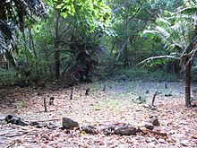
The burial ground is within one of the old coral-walled lots about fifty meters inland from the Efate-facing coast. Above ground it can be recognized by some gravestones, large mussel shells and conspicuously regularly planted sago palm ferns.
The excavation revealed not only the bones of Roi Mata, but also of over fifty other people. The analysis of the historians says that most of them voluntarily let themselves be buried alive with their ruler. The dead lie in regular rows in pairs, the women nestled against the men at their sides.
Not the entire garden has been examined, so it is possible and likely that more graves can be found there. However, these likely belong to burials made at other times.
After the end of the work, the graves were closed again and their boundaries marked with a line made of pieces of coral. The tombstones were put up again. Only the jewelry was removed from the graves in order to be able to examine it further. It is now held in trust in the National Museum in Port Vila .
Web links
- Entry on the UNESCO World Heritage Center website ( English and French ).
- Nomination documents (PDF, 43 MB) of the Republic of Vanuatu for the entry of Chief Roi Mata's Domain in the World Heritage List, 2006/07 (English)


