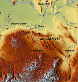
Cholm (Amu Darya)
| Cholm | ||
| Data | ||
| location | Balch , Samangan ( Afghanistan ) | |
| River system | Amu Darya | |
| Drain over | Amu Darya → Aral Sea (temporarily) | |
| source | at the Kara Kotal Pass in the Hindu Kush 35 ° 35 ′ 30 ″ N , 68 ° 12 ′ 21 ″ E |
|
| Source height | approx. 3600 m | |
| Infiltration | Desert in northern Afghanistan Coordinates: 36 ° 48 ′ 42 ″ N , 67 ° 48 ′ 12 ″ E 36 ° 48 ′ 42 ″ N , 67 ° 48 ′ 12 ″ E |
|
| Mouth height | approx. 370 m | |
| Height difference | approx. 3230 m | |
| Bottom slope | approx. 14 ‰ | |
| length | approx. 230 km | |
| Catchment area | 8400 km² | |
| Discharge at the Sayad A Eo gauge : 8170 km² |
MQ 1964/1978 Mq 1964/1978 |
2.02 m³ / s 0.2 l / (s km²) |
| Discharge at Tangi Tashqurghan A Eo gauge : 8220 km² |
MQ 1969/1978 Mq 1969/1978 |
2.42 m³ / s 0.3 l / (s km²) |
| Medium-sized cities | Aybak | |
| Small towns | Cholm | |
The Cholm (also Darya-i Khulm ) is a river in the central north of Afghanistan .
The Cholm rises at the Kara-Kotal Pass in the Hindu Kush on the provincial border of Baglan and Samangan . It initially flows west, but then turns north. It flows through the entire province of Samangan and passes its capital Aybak . Later, he cuts through the ridge of Marmalgebirges and reaches the province Balch town in Chelm . There it forms an alluvial cone . In earlier years the Cholm flowed another 30 km to the Amu-Darja and flowed into it. Due to the heavy use of river water for irrigation, the Cholm now usually seeps away in the desert in the far north of Afghanistan. The Cholm has a length of 230 km. It drains an area of 8400 km².
Hydrometry
Average monthly discharge of the Cholm (in m³ / s) at the Tangi Tashqurghan gauge
measured from 1969–1978

Individual evidence
- ↑ a b c Streamflow Characteristics at Streamgages in Northern Afghanistan and Selected Locations (PDF 5.6 MB) USGS.
