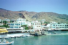
Chora Sfakion
Chora Sfakion ( Greek Χώρα Σφακίων ( f. Sg. ), Also transcribed Chora Sphakion ) is a coastal town in the south of the island of Crete with a small port on the Libyan Sea . In 2001 it had 212 inhabitants and is the capital of the historical region and today's municipality (Dimos) Sfakia .
geography
Chora Sfakion is located in the south of western Crete on the Libyan Sea, one kilometer west of the exit of the Sfakiano Gorge. The "center" of the place with taverns, some hotels and shops is located directly at the old port, the other districts are on the foothills of the Lefka Ori , the 'White Mountains', which slope down to the sea .
history
In the Middle Ages the place was called Omprosgialos . Chora Sfakion was one of the centers of the Cretan resistance against foreign invaders (Venetians, Turks and, most recently, the Germans during the Second World War ).
From here, more than 10,000 Allied soldiers were disembarked for Egypt after the airborne battle for Crete at the end of May 1941. At the special enterprise League of Nations , 25 Cretans were shot in Chora Sfakion in September 1941 for supporting the Allied soldiers and for resisting the German occupiers.
The Sfakioten, the inhabitants of the region, are still considered particularly proud, rough and brave.
Economy and Infrastructure
The main line of business is tourism, alongside fishing and sheep and goat farming. Since Sfaki baked goods are also in demand on the mainland and abroad, a large bakery was built in the village in 2007, which will also produce for supraregional needs. The local taverns live mainly from transit and hiking tourists. Some of them are visitors to the Samaria Gorge , who are brought to or from there by ships (via Agia Roumeli). Other well-known gorges nearby are the Imbros Gorge in the east and the Aradena Gorge in the west. There is a small beach on site (Vryssi beach) and a few others nearby, e.g. B. at the exit of the Ilingias Gorge and between Chora Sfakion and Loutro ( Glyka Nera ). The latter can only be reached by boat or on foot.
traffic
There is a spectacular pass road to the north ( Chania ), a road along the coast to the east via Frangokastello and Sellia to Rethymno or into the Messara plain and a winding road to the west up to Anopolis and over the Aradena Bridge to Agios Ioannis.
The two south coast towns of Agia Roumeli and Loutro can be reached from Chora Sfakion on foot (via the European long-distance hiking trail E4 ) or by ferry. There is also a ferry connection to the island of Gavdos in summer. A larger port to the east of the town has been in operation since 2005 and now offers very good protection against bad weather from all directions. 75% of the construction costs of 5.6 million euros were financed by the EU .
Individual evidence
- ↑ Results of the 2011 census at the National Statistical Service of Greece (ΕΣΥΕ) ( Memento from June 27, 2015 in the Internet Archive ) (Excel document, 2.6 MB)
- ^ History of Crete & the Region of Sfakia
- ↑ nzhistory.net.nz
- ↑ Manouselis, Giorgios: Sfakia, Petrina Chronia 1940-45. Sfakia: Stone years 1940–45. P. 107 ff.
Web links
- horasfakion.com
- Website about the place and the surrounding region
- Website about the place
- Website with more than 1000 Sfakia photos from the 60s until today
Coordinates: 35 ° 12 ' N , 24 ° 8' E


