
Rethymno
|
Rethymno municipality Δήμος Ρεθύμνου |
|||
|---|---|---|---|
|
|||
| Basic data | |||
| State : |
|
||
| Region : | Crete | ||
| Regional District : | Rethymno | ||
| Geographic coordinates : | 35 ° 22 ′ N , 24 ° 28 ′ E | ||
| Area : | 397.48 km² | ||
| Residents : | 55,525 (2011) | ||
| Population density : | 139.7 inhabitants / km² | ||
| Community logo: |
|
||
| Seat: | Rethymno | ||
| LAU-1 code no .: | 7301 | ||
| Districts : | 4 municipal districts | ||
| Local self-government : |
2 city districts 45 local communities |
||
| Website: | www.rethymno.gr | ||
| Location in the Crete region | |||
 |
|||

Rethymno ( Greek Ρέθυμνο [ ˈrɛθimnɔ ] ( n. Sg. ), Outdated also Rethymnon ) is a port city in the north of the Greek island of Crete . It is the third largest city on the island after Heraklion and Chania and, as a municipality of the same name (Δήμος Ρεθύμνου, Dimos Rethymnou ), forms the center of the regional district of Rethymno .
In addition to Heraklion, Rethymno is one of the two locations of the University of Crete , the location of a state hospital and, until October 2008, was also the port of call for ferries from Piraeus .
geography
location

Rethymno is located between the other two larger cities of Crete, 60 kilometers west of Heraklion and 45 kilometers east of Chania. The urban area of Rethymno extends in an east-west orientation 5.5 kilometers along the north coast of the island on the Cretan Sea , part of the Aegean Sea and the Mediterranean Sea . The center and the historical core of the city lie on a rocky peninsula, the bay to the east of it enabled the construction of a port.
From the coast, the closed development near the city center only extends up to 1.5 kilometers to the south. The municipal area, however, extends up to 13 kilometers into the interior of the island. From the southernmost point of the municipality near the 1310 meter high mountain Kryoneritis (Κρυονερίτης) to the south coast of Crete on Koraka beach near Rodakino (Ροδάκινο) it is about five kilometers.
On the longitude of Rethymno the mountain ranges of the island are not as pronounced in their height as the Ida Mountains ( Psiloritis) on the eastern border of the regional district or the White Mountains (Lefka Ori) in the west, in the regional district of Chania . Several pass roads lead from Rethymno to the south coast, through the Kourtaliotiko Gorge or the Kotsifou Gorge to Plakias , the capital of the Finikas municipality in the municipality of Agios Vasilios , and via Spili through the Lambi municipality to Agia Galini on the Mesara Bay (Όρμος Μεσαράς) of the Libyan Sea .
geology
The island of Crete is located on the South Aegean arch , an extension of the Dinaric mountain arch over the Hellenic mountain range on the Greek mainland to the Taurus Mountains in Asia Minor . These Alpidic mountain formations arose from the geological period of the early Tertiary , which is now referred to as the paleogene , when the African plate began to push itself under the Eurasian plate due to the continental drift . Even today, the African plate drifts about four centimeters northwards every year, which can occasionally lead to earthquakes in the region. The highest point of the municipality of Rethymno is the 858 meter high Vrysinas ( Βρύσινας ), about three kilometers east of the village Armeni .
Crete, located in the subduction zone of the two continental plates, tilts around its north-south axis during geotectonic activities: the west of the island rises while the east sinks slightly. Since the urban area of Rethymno is on a plain in the northwest of Crete, the rock layers there are also of more recent geological date than those of the Lefka Ori or the Psiloritis massif, for example . The city stands on rock and sediment formations from the Young Tertiary or Neogene (around 30 million years old), which date from a time when the north-western coastal plain was still part of the sea. The rock of the southern municipality of Rethymno, slate , phyllite and crystalline rock with limestone layers above it , on the other hand, comes from earlier geological epochs.
Neighboring communities
In the west, the municipality of Apokoronas borders on the municipality of Rethymno. Sfakia is located southwest of Rethymno , to the east bordering the municipality of Agios Vasilios , which extends over the entire south coast of the Rethymno regional district. The municipality of Mylopotamos begins at the eastern border of Rethymno, and to the southeast lies the municipality of Amari .
| Apokoronas |
.svg)
|
Mylopotamos |
| Sfakia | Agios Vasilios | Amari |
With the exception of Apokoronas and Sfakia, the neighboring communities of the municipality of Rethymno belong to the Rethymno regional district. The main town of the regional district is not in its center, but in its northwestern area. For the accessibility of the regional district communities to the city of Rethymno, however, the island relief plays a greater role than the proximity to the main town, which means that the northern communities are infrastructurally preferred due to better road connections.
Community structure and number of inhabitants
The city of Rethymno has 34,300 inhabitants on an area of 26.777 km², which corresponds to a population density of 1280.95 inhabitants / km². As a municipality, Rethymno has an area of 397.48 km² with 55,525 inhabitants. This means that there are 139.69 inhabitants / km² in the municipality (data from 2011).
Rethymno is divided into five municipal districts. These are the independent communities of Arkadi, Lappa, Nikiforos Fokas and Rethymno, which existed until 2010. The local self-government is exercised by two urban districts (gr. Dimotikes kinotites ), namely Rethymno and Atsipopoulo, as well as 45 local communities topikes kinotites , which in turn consist of 100 settlements.
| City district / local community |
Parish | Area (km²) | Residents | Settlements (residents) |
|---|---|---|---|---|
|
Adele (Άδελε) |
Arkady | 6.428 | 1,415 | Adele (489) Agia Paraskevi (Αγία Παρασκευή, 246) Adelianos Kambos (Αδελιανός Κάμπος, 680) |
|
Amnatos (Αμνάτος) |
Arkady | 23,537 | 218 | Amnatos (156) Kafaliana (Καψαλιανά, 1) Moni Arkadiou (Μονή Αρκαδίου, 6) Pikris (Πίκρης, 55) |
|
Archea Eleftherna (Αρχαία Ελεύθερνα) |
Arkady | 9.979 | 115 | Archea Eleftherna |
| Chamalevri (Χαμαλεύρι) |
Arkady | 3.701 | 877 | Chamalevri (111) Asteri (Αστέρι, 88) Stavromenos (Σταυρωμένος, 678) |
| Charkia (Χάρκια) |
Arkady | 20.61 | 78 | Charkia (62) Kavousi (Καβούσι, 16) |
| Eleftherna (Ελεύθερνα) |
Arkady | 10.88 | 189 | Eleftherna |
| Erfi (Έρφοι) |
Arkady | 6,978 | 662 | Erfi (141) Agios Nikolaos (Άγιος Νικόλαος, 136) Ano Viranepiskopi (Άνω Βιρανεπισκοπή, 94) Viranepiskopi (Βιρανεπισκοπή, 122) Magnisia (Μαγνησία, 169) |
| Kyrianna (Κυριάννα) |
Arkady | 5.253 | 348 | Kyrianna |
| Mesi (Μέση) |
Arkady | 8,654 | 388 | Mesi (48) Agia Triada (Αγία Τριάδα, 62) Loutra (Λούτρα, 278) |
| Pangalochori (Παγκαλοχώρι) |
Arkady | 2,426 | 969 | Pangalochori (177) Sfakaki (Σφακάκι, 792) |
|
Pigi (Πηγή) |
Arkady | 6.003 | 857 | Pigi (401) Agios Dimitrios (Άγιος Δημήτριος, 177) Pigianos Kambos (Πηγιανός Κάμπος, 279) |
| Prinos (Πρίνος) |
Arkady | 12,905 | 660 | Prinos (310) Skaleta (Σκαλέτα, 350) |
| Skouloufia (Σκουλούφια) |
Arkady | 5.673 | 160 | Skouloufia (123) Roupes (Ρούπες, 37) |
|
Argyroupoli (Αργυρούπολι) |
Lappa | 6.124 | 403 | Argyroupoli |
| Archondiki (Αρχοντική) |
Lappa | 3.45 | 244 | Archondiki |
| Episkopi (Επισκοπή) |
Lappa | 6,999 | 755 | Episkopi (618) Pyrgos (Πύργος, 137) |
| Caroti (Καρωτή) |
Lappa | 3,675 | 275 | Caroti |
| Kato Poros (Κάτω Πόρος) |
Lappa | 2.625 | 53 | Kato Poros |
| Koufi (Κούφη) |
Lappa | 2,475 | 127 | Koufi |
|
Myriokefala (Μυριοκέφαλα) |
Lappa | 13.226 | 309 | Myriokefala (268) Maroulou (Μαρουλού, 41) |
| Vilandredo (Βιλανδρέδο) |
Lappa | 12,558 | 191 | Vilandredo (73) Alones (Αλώνες, 35) Arolithi (Αρολίθι, 9) Roumbado (Ρουμπάδο, 17) |
| Agios Konstandinos (Άγιος Κωνσταντίνος) |
Nikiforos Fokas | 5.05 | 200 | Agios Konstandinos (152) Agios Georgios (Άγιος Γεώργιος, 48) |
| Ano Valsamonero (Άνω Βαλσαμόνερο) |
Nikiforos Fokas | 5,599 | 107 | Ano Valsamonero (77) Monopari (Μονοπάρι, 30) |
|
Atsipopoulo (Ατσιπόπουλο) |
Nikiforos Fokas | 9.449 | 4,947 | Atsipopoulo (1,392) Agna (Αγνά, 363) Violi Charaki (Βιολί Χαράκι, 2785) Panorama (Πανόραμα, 407) |
| Frantzeskiana Metochia (Φραντζεσκιανά Μετόχια) |
Nikiforos Fokas | 2.7 | 250 | Frantzeskiana Metochia |
|
Gerani (Γεράνι) |
Nikiforos Fokas | 11,399 | 883 | Gerani (821) Petres (Πετρές, 62) |
| Gonia (Γωνιά) |
Nikiforos Fokas | 6.124 | 534 | Gonia (331) Agios Andreas (Άγιος Ανδρέας, 203) |
| Kalonyktis (Καλονύκτης) |
Nikiforos Fokas | 2.9 | 222 | Kalonyktis |
| Kato Valsamonero (Κάτω Βαλσαμόνερο) |
Nikiforos Fokas | 7.024 | 193 | Kato Valsamonero |
| Malaki (Μαλάκι) |
Nikiforos Fokas | 9.299 | 138 | Ano Malaki (Άνω Μαλάκι, 77) Kato Malaki (Κάτω Μαλάκι, 61) |
|
Moundros (Μούντρος) |
Nikiforos Fokas | 9,799 | 179 | Moundros (91) Velonado (Βελονάδο, 88) |
| Prines (Πρινές) |
Nikiforos Fokas | 7.749 | 884 | Prines (851) Vederi (Βεδέροι, 33) |
|
Roustika (Ρούστικα) |
Nikiforos Fokas | 4.55 | 203 | Roustika (150) Palelimnos (Παλαίλιμνος, 53) |
| Saitoures (Σαϊτούρες) |
Nikiforos Fokas | 11,424 | 105 | Saitoures |
| Zouridi (Ζουρίδι) |
Nikiforos Fokas | 2.575 | 66 | Zouridi |
|
Armeni (Αρμένοι) |
Rethymno | 19,998 | 706 | Armeni (379) Agios Georgios (Άγιος Γεώργιος , 87) Somatas (Σωματάς, 161) Fotinos (Φωτεινός, 79) |
|
Chromonastiri (Χρομοναστήρι) |
Rethymno | 9.604 | 391 | Chromonastiri (298) Kapediana (Καπεδιανά, 25) Myli (Μύλοι, 27) Prinedes (Πρινέδες, 41) |
|
Goulediana (Γουλεδιανά) |
Rethymno | 5.202 | 106 | Goulediana (73) Geni (Γενή, 3233) |
|
Kare (Καρέ) |
Rethymno | 7,899 | 192 | Kare (81) Ambelaki (Αμπελάκι, 111) |
|
Kastellos (Κάστελλος) |
Rethymno | 6.324 | 108 | Castellos |
|
Koumi (Κούμοι) |
Rethymno | 8,399 | 172 | Koumi |
|
Maroulas (Μαρουλάς) |
Rethymno | 11.43 | 547 | Maroulas (486) Dilofo (Δίλοφο, 61) |
|
Oros (Όρος) |
Rethymno | 2.825 | 54 | Oros |
|
Prasies (Πρασιές) |
Rethymno | 7,953 | 133 | Prasies |
| Rethymno | Rethymno | 26.777 | 34,300 | Rethymno (32.468) Agia Irini (Αγία Ειρήνη, 75) (Mikra) Anogia (Μικρά Ανώγεια, 131) Gallos (Γάλλος, 922) Giannoudi (Γιαννο, ιρδι, 116) Megalo Metochi ( Μικρά Μόχγτάτochi (Μιγτάτο 46 Μεγτάochi (Μιττκο Μόχεγτάκο 46 ΜΜτόχτochi ) 46 Μεγτάκο (Μιγτατο 46 ΜΜγτατο Μόχεγτιο Μόχεγττο ιγτο όχεγτατο ιεγτιο όχεγτάochi (Μιγτάκο Μιρδι) Xiro Chorio (Ξηρό Χωριό, 221) Tria Monastiria (Τρία Μοναστήρια, 172) |
|
Roussospiti (Ρουσσοσπίτι) |
Rethymno | 6.84 | 569 | Roussospiti |
|
Selli (Σελλί) |
Rethymno | 13.205 | 184 | Selli (110) Myrthios (Μύρθιος, 74) |
The population figures indicate the status at the time of the 2011 census . Population development of (the area and the suburbs of the city) Rethymno
| Surname | 1940 | 1951 | 1961 | 1971 | 1981 | 1991 | 2001 | 2011 |
|---|---|---|---|---|---|---|---|---|
| Rethymno | 8,648 | 11,057 | 14,999 | 14,969 | 17,136 | 23,355 | 27,868 | 32,468 |
| Agia Irini | 96 | 88 | 63 | 47 | 34 | 63 | 49 | 75 |
| Agios Markos | - | - | - | - | 18th | 65 | - | - |
| Anogia | 50 | 25th | 25th | 21st | 13 | 15th | 89 | 131 |
| Gallos | 315 | 274 | 252 | 180 | 146 | 205 | 430 | 922 |
| Giannoudi | 92 | 82 | 78 | 30th | 22nd | 23 | 96 | 116 |
| Kastellakia | - | 45 | 27 | 36 | 105 | - | - | - |
| Koumbes | - | 106 | - | - | - | - | - | - |
| Megalo Metochi (Risvan) | - | 33 | 25th | - | 6th | 28 | 29 | 46 |
| Metochi Albani | 67 | 79 | 31 | - | - | - | - | - |
| Micro metochi | - | - | - | - | 29 | 91 | 188 | 149 |
| Misiria | 294 | 212 | - | - | - | - | - | - |
| Perivolia | 853 | 805 | - | - | - | - | - | - |
| Planates | 343 | 488 | - | - | - | - | - | - |
| Tria Monastiria | - | - | - | - | 18th | 105 | 107 | 172 |
| Xiro Chorio | 214 | 219 | 132 | 90 | - | 114 | 131 | 221 |
| total | 10,972 | 13,513 | 15,632 | 15,373 | 18,190 | 24,064 | 28,987 | 34,300 |
climate
Crete has a Mediterranean climate with mild, rainy winters and hot, dry summer months. There are considerable climatic differences between the regions of the island. The average temperatures on the south coast are slightly higher than those in the north, while those of the mountainous regions are generally fresher. There is also less rainfall in the east and south of the island. Due to the high mountains of Crete, weather conditions often change quickly and winds arise, which also intensify into a hurricane-like storm.
The often strong northern or southern winds play an important role in the moderate Mediterranean climate of Rethymno. Average temperatures in the city are around 14 ° C in winter and 29 ° C in summer. A hot summer is followed by a rainy autumn. The rainy months last from October to the end of March.
|
Average monthly temperatures and rainfall for Rethymno
|
|||||||||||||||||||||||||||||||||||||||||||||||||||||||||||||||||||||||||||||||||||||||||||||||||||||||||||||||||||||||||||||||||||||||||||||||||||||||||||||||||||||||||||||||||||||||||||||||||||||||||||||||||||||||||||||||||||||||||||||||||||||||||||||||
history
The area of Rethymno was settled as early as the Neolithic Age (6000–2600 BC ). Archaeological finds from the Idean grotto (Ιδαίον Άντρον, Ideon Andron ) in the Psiloritis massif , from the Gerani cave west of Rethymno and from Elenon in the area of Amari testify to this . The first indications of a settlement in the urban area of Rethymno come from the late Minoan period (1350–1250 BC). A rock grave with grave goods was uncovered in the southern district of Mastabas . A cemetery near the municipality of Armeni belongs to the same period. Near this place was in the following geometric and classical period (1100-620 v. Chr.) A settlement on the plateau Onythe the mountain Vrysinas .
Ancient rhithymna and Byzantine times

In Classical and Hellenistic times, the ancient Rhithymna (Ῥίθυμνα) was a small but prosperous city. The name Rhithymna is pre-Hellenic and perhaps suggests a Carian or Lycian origin. It is inscriptions and finds of coins minted in the city from the 4th and 3rd centuries BC. To be found in BC. These coins depict a helmeted head, possibly of the gods Apollo or Athena , on one side , and sea symbols such as two dolphins or a trident are depicted on the lapel. The current name Rethymno as well as the city logo with the two dolphins are borrowed from ancient times.
However, it is not certain whether the ancient Rhithymna was on the site of today's city of Rethymno. Notes on the location of Rhithymna can be found in Pliny the Elder (1st century AD), there as Rhytium , and Claudius Ptolemy (2nd century AD), who described a location between Panormos and Georgioupoli . The Roman sophist Claudius Aelianus mentioned a temple of Artemis of Rokkaia ( Diana of Rhoccaea ) in the 3rd century , which is said to have been on the hill Paleokastro in Rethymno within an acropolis . In the 16th century the Venetians built the Fortezza there , the fortress still existing in parts today, and they probably tore down the remains of a former temple. The site, which is now in the center of the city, was named by them Paleocastro ('Old Fortress').

Rhithymna continued to exist as a small town during the Roman period (67 BC – 395 AD) and the first Byzantine epoch (395–824), but was probably destroyed when the Arabs conquered Crete between 824 and 828 . It is believed that the conquerors were Arabs who fled to Alexandria after an uprising in the emirate of Córdoba in what is now Spain , and who under Emir Abu Hafs Omar undertook a raid into southern Crete as early as 823. Attempts to recapture the weakened Byzantine Empire in 825, 826, 828 and 902 were unsuccessful. General Nikephoros Phokas , who later became Emperor Nikephoros II, succeeded in reintegrating the island into the Byzantine Empire in 960/961. Many of the Cretan cities destroyed by the Saracens were rebuilt afterwards. To protect them from further attacks, they were fortified with city walls, including the Castrum Rethemi , later Castel Vecchio by the Venetians .
The second Byzantine epoch of Crete ended after Constantinople was captured on April 13, 1204 by the crusaders of the Venetian-financed Fourth Crusade under the leadership of the Piedmontese margrave Bonifatius of Montferrat , who sold the island to the Venetians for 10,000 silver marks to settle the war debts in 1210 . In 1206 the island was occupied by the privateer Enrico de Candia , called il Pescadore (the fisherman). After years of fighting, the Venetians conquered the fortified Cretan cities by the by the Genoese supported and partly the native population privateers, with 1,207 Spinalunga , 1208 Paleocastro and 1210, the remaining coastal fortifications went over into their possession. In 1212 the Venetians secured control of Crete in an armistice with Genoa, and in 1218 they took the entire island against the resistance of the locals.
Venetian time

The new masters divided Crete into six administrative regions, which were named after the six districts ( sestiere ) of Venice: Santi Apostoli , San Marco , Santa Croce , Castello , San Polo and Dorsoduro . The headquarters with the Duca as the most powerful man on the island was in Chandakas (later Candia ), in the Territorio de Candia . The city of Rethymno became the capital of the province of Castello as Retimo . It retained this status even after being reduced to four administrative regions in the 13th century. A Rettore ('Rector') ruled as governor in the provincial capitals, assisted by two Consiglieri ('Councilors'). Retimo also gained greater importance through its port of Mandraki (Μανδράκι) as an intermediate port halfway from La Canea to Candia , the two naval bases of the Venetians.
The introduction of the Venetian feudal system and attempts to curtail Orthodoxy led to numerous uprisings between 1211 and 1367. 27 larger or smaller, locally limited surveys of a social and national character are mentioned. The uprising from 1363 to 1366 came from Venetian settlers who opposed a tax policy in Venice that was perceived as arbitrary. Earthquakes also significantly disrupted the economic development of the Cretan cities, so on August 8, 1303 there was severe destruction in Retimo by a severe earthquake and a tsunami that was probably triggered by it . The greatest threat to Venice's supremacy in the eastern Mediterranean, however, was the fall of Constantinople to the Ottoman Empire on May 29, 1453.

After the Ottoman conquest of the capital of the Byzantine Empire, many Greek Orthodox Christians fled Constantinople to Christian areas not yet occupied by the Ottomans, including Crete. In the cities of the island a demographic change took place to the disadvantage of the Catholic Venetians. The Republic of Venice initially maintained a friendly relationship with the Ottoman Empire in order not to endanger the trade routes. This changed in 1535 when Sultan Suleyman I entrusted his Kapudan Pasha (Grand Admiral - Commander in Chief of the Navy ) Khair ad-Din Barbarossa with driving the Christian powers out of the Levant and the Aegean and Adriatic Seas in order to bring the sea routes under Ottoman control to get.

After the Ottoman fleet was upgraded to over 100 galleys in 1536, Khair ad-Din Barbarossa led the force through the Aegean Sea to Apulia in 1537 . No Christian power of the time dared to face this threat. Many Venetian properties were plundered or incorporated into the Ottoman Empire, including the islands of Syros , Aegina , Ios , Paros , Tinos , Karpathos , Kasos and Naxos . In 1538 the " Holy League " was formed, but with a fleet of 302 ships it was defeated by the Ottomans in the naval battle of Preveza . Fortifications were planned in Retimo in 1537/1538, which the Veronese architect Michele Sanmicheli worked out. You should also include the Retimo suburb outside of Castel Vecchio . Construction of the new fortifications had not yet started when Khair ad-Din Barbarossa sacked the province of Apokorona (between Souda and Rethymno) and the outskirts of the cities of La Canea , Retimo and Sitia in 1538 .


In 1540 the construction of the city wall began in Retimo, the original plans were simplified for financial reasons. Only the eastern Santa Barbara bastion was built according to the original plans by the architect Sanmicheli. The fortification stretched along today's streets Dimakopoulou and Gerakari on the southern edge of what was then the suburb from the beach southeast of the harbor to below the Paleokastrou hill on the rocky west coast. In addition to the main gate, the Porta Guora (today mostly called Megali Porta 'Great Gate'), which was built next to the Santa Veneranda Bastion about in the middle of the wall at today's Tessaron-Martyron-Platz , two more gates were integrated in the east and to the west of the fortification. In the west, the fortress construction ended at the Kalergi bastion , of which rudiments are still preserved. In 1562 and 1567, two attacks by Ottoman pirates on the city, which had around 4485 inhabitants in 1560, are known, of which little has been known. Work on the new city fortifications was completed in 1570.
Under Sultan Selim II , the Ottomans went on the offensive again. On July 3, 1570, an army of 20,000 men landed on the island of Cyprus , the easternmost Venetian colony . By September 18, the Ottoman army , which had grown to around 100,000 men, had conquered the entire island except for Famagusta , which only surrendered on August 1, 1571. The Christian states wanted to counter the conquest of Cyprus with a relief fleet under the command of Giovanni Andrea Doria , which gathered in the Cretan Souda Bay at the end of August 1570 . As a result of the delayed departure of the fleet only at the end of September due to an intervention by King Philip II of Spain , news of the fall of Nicosia on September 9, 1570 was received on the way . Not to mention the strong Ottoman naval units under Grand Admiral Müezzinzade Ali Pascha from the west, which were now acting more freely To be cut off the Mediterranean Sea, the fleet withdrew to southern Italy. Crete was now the easternmost outpost of Venice in the Mediterranean.
The consequences of the Ottoman naval superiority in the Aegean were already apparent for Retimo a year after the attack on Cyprus. In the spring of 1571, the Pasha of Algiers and Tunis , Beylerbey of North Africa and Ottoman Admiral Uludsch Ali Pascha ( Turkish: Uluç Ali Paşa ) sailed from Algiers with 20 galleys to Koroni on the southern tip of the Morea to meet with the fleet of the Müezzinzade Ali Pascha unite. In the protection of the fleet, Uludsch Ali ( Greek Ουλούτζ Αλή , Italian Occhiali ) made several forays into the Ionian and Aegean Seas. He attacked Retimo on July 7, 1571, sacked the city and burned it down. The capture of the city was favored by the neglected fortifications on the sea side, so that Uludsch Ali could easily land with his galleys. Most of the city's buildings and the recently completed new city wall were largely destroyed. The residents of Retimo were able to flee from the Ottomans.
With the lost naval battle of Lepanto on October 7, 1571 against the fleet of the " Holy League ", the dream of a world power at sea for the Ottoman Empire was destroyed. The Republic of Venice, also weakened, sought a separate peace and withdrew from the "Holy League". The Venetians even recognized the Ottoman suzerainty over Cyprus in 1573. In Retimo, lessons were learned from the inadequate city fortifications and the plan was to move the city to a closed fortification on the Paleocastro hill west of Castel Vecchio . The foundation stone for the fortress, the Fortezza , was laid in 1573 under the Rettore Alvise Lando . However, the area of the fortress was too small to accommodate the entire city. Therefore, after completion in 1578, it was decided to use it as a place of refuge for the 8,500 residents and otherwise to accommodate the Venetian administration, the Latin bishopric and the army authorities.


During the reconstruction of Retimo, many of the buildings that still exist today were created in a late form of the Venetian Renaissance , Mannerism . The new urban structure was based on Venice. With the piazza , a central square was created and from a main street smaller side streets led to churches, monasteries, mansions with magnificent portals and the simpler city quarters. The three town churches of Santa Maria Maddalena , Santa Maria and San Francesco were built, public fountains such as the Rimondi Fountain were built, and a meeting place for the nobles, the loggia designed by Michele Sanmicheli, was built where they could discuss political and economic issues .
The city had a politically and culturally liberal climate, which made Retimo a place of work for outstanding scholars and artists, among them Markos Mousouros , Zacharias Kallierges , Nikolaos Vlastos and Angelos Vergikios , poets and writers such as Georgios Chortatzis , Ioannis Andreas Troilos and Marinos Tzane Bounialis as well as the painters Emmanouil Lomvardos and Emmanouil Tzane Bounialis , representatives of the so-called Cretan school , a form of post-Byzantine icon painting influenced by the Venetian Renaissance . The last phase of the rule of the Republic of Venice over Crete, which was characterized by a balance between the culture of the Catholic Venetian upper class and the Greek Orthodox majority, ended with the conquest of the island by the Ottoman Empire.
During the reign of Sultan İbrahim , a 60,000 strong Ottoman army landed on June 25, 1645 in the Bay of Gogna (Gonia) near Kolymbari west of La Canea (Chania) and began to siege the city on June 26. After almost two months, La Canea fell on August 17, 1645 as one of the first cities in Crete. A year later, on September 29, 1646, the Ottomans faced Retimo. The poorly fortified city was taken by the troops of its commander-in-chief Hussein Pascha (Turkish Hüseyin Paşa , also bearing the prefix Gazi or Deli ) after 14 days in October 1646. General Cornaro and Provveditore Molino fell on the Venetian side during the fighting. After the siege of Fortezza , into which the city's population had withdrawn, and the demolition and storming of the great tower on the sea side of the fortress on November 13, 1646, the defenders surrendered the following day. The Venetians were able to negotiate favorable terms of surrender and were given free retreat to Candia (Heraklion).
Ottoman time
Not all of Retimo's residents left the city for Candia after the Ottoman occupation ; many submitted to the rule of the sultan. The 110 or so Venetians captured before the surrender of the Fortezza when the city was taken were brought to Kostantiniyye , their further fate is unknown. The city called Resmo by the Ottomans was sacked and food and 150 horses were transported to the Ottoman Hanya (Chania). The conqueror of Retimo, Hussein Pascha, honored by Sultan İbrahim with a “golden dress of honor” and a “golden saber of honor”, sent 50,000 piastres to the sultan and 5,000 piastres for the grand vizier Salih Pascha from Resmo to the capital of the empire. As the last bastion of Venice in the area of Rethymno, the Castello di Milopotamo near Panormos was occupied by the Ottomans in mid-January 1647 .

Resmo gradually acquired a Muslim character. As early as January 12, 1647, the main Catholic church of San Nicolo in the center of the Fortezza was rededicated as the Sultan Ibrahim Mosque . Other churches have been converted into mosques or demolished. The Christians formed the majority of the residents of Resmo, but, like the Jews, were subjects of inferior rights. Many of the residents of the former cultural elite left the city, mostly for Venice or the Ionian Islands. However, Venetian-inspired buildings were also built under the Ottoman administration. Originally Venetian houses were equipped with characteristic wooden cores, which allowed Muslim women to see the streets without being seen themselves.

After Candias surrendered after a 21-year siege on September 6, 1669, Crete was divided into three sectors as the Ottoman province of Kirid . Besides Hanya (Chania) and in Megalo Kastro renamed Candia (Heraklion) was Resmo one of the three, later Sitia four seats of a pasha. In addition to the majority of the Greek Orthodox population, some Venetian merchants and craftsmen had also stayed in the city. The silting up of the port led to the city's gradual decline in the centuries that followed. The suppression of uprisings in the years 1770, 1821, 1857, 1866–68, 1879 and 1889, but also the conversion to Islam, often under duress, led to a Muslim majority in the cities of the island at the end of the 19th century.

In 1864, local self-government was introduced in Crete and Muslim mayors appointed by the Ottoman authorities were installed. In the Chalepa Treaty of 1878, the election of mayors by the (male) local population was established, at the same time a first (α΄ Δημαρχιακός Πάρεδρος) and two second deputy mayors (β΄ Δημαρχιακοί Πάρεδροι) and an eight to ten-member councilor were introduced. The mayors had to be Muslim, the Christians were only allowed to hold the deputy positions. The majority of the population of Resmo was Muslim at the time: According to the 1881 census, around 73% of the city's 9135 residents were Muslims, compared to 27% Christian. Sali Drosoulakis, born in 1842, was Resmos's first elected mayor. He held the office from 1882 to 1885 and from 1889 to 1895.
After the extensive autonomy of Crete as a result of the intervention of the great powers after the Turkish-Greek War and the peace treaty of December 4, 1897, the mayors of the city now called Rethymno (also Rethymnon) were appointed by the protecting powers. Since Rethymno was under a Russian mandate , a Russian captain named Kuzerowski was superordinate to the mayor from 1898 to 1905 . The period from 1898 to 1913 was a phase of new beginnings in the economic and cultural sector, in which the infrastructure in Rethymno was improved, luxurious private and public buildings were built and several theaters and a cinema were opened.
Greek time
In Crete, which has belonged to Greece since December 1, 1913, the Turk Vakoglaki remained mayor of Rethymno until 1918, after which only Greek citizens were mayor. During the term of office of Menelaus Papadakis, the Turks were completely expelled from the city as a result of the Treaty of Lausanne ; he also ordered the conversion of the Muslim cemetery into the Volksgarten (Δημοτικός Κήπος) that still exists today. The years 1926 to 1950 were the tenure of lawyer Titos Petychakis, who was responsible for many modernizations of the city such as electrification, the asphalting of the streets and the construction of a modern sewage system. Only during the German occupation in World War II was his government interrupted by two mayors appointed by the German occupation forces.

On May 20, 1941, around 7:15 a.m., the airborne battle for Crete ( Operation Merkur ) began the occupation of the island of Crete by the German Wehrmacht during World War II . First of all, the planned drop-off zones for the paratroopers planned for an air landing were bombed by the German Air Force , in addition to the targets near Maleme , Chania and Heraklion, the city and the area around Rethymno. After the first jumps of the German paratroopers near Maleme and Chania, a second wave of attacks took place at around 4:15 p.m., with Rethymno as the target. Because of the strong resistance of the Allies , the goal of taking the city's airport could not be achieved in the following days. Among the 1380 German paratroopers deployed there were 400 dead, missing or wounded on the first day. Only after the decision of the British High Command to evacuate Crete did Rethymno capitulate on May 29, 1941 and was occupied by German troops.
In the post-war period, local politics was shaped by the conservative philologist Dimitrios Archondakis, who led the city as mayor for the first time under the military dictatorship from 1968 to 1974 , but was later re-elected twice and until 2006 held office three times for a total of 27 years. The incorporation of the rural surrounding villages on the occasion of the Greek municipal reform of 1997 strengthened his position considerably: in the 1998 elections he received 55.76% of the vote. In 2006 he was replaced by the lawyer Giorgis Marinakis, who achieved the best election result after the war with 60.57% and took over the city government for the socialist PASOK .

politics
Municipal council
Rethymno is governed by a 27-member municipal council. In the local elections in 2006, the candidate of the socialist PASOK was elected mayor with 60.58% of the vote and thus achieved 16 seats for his party; Ninos Nikos and the list of conservative Nea Dimokratia had 11 seats. The mayor is supported by five vice mayors who head various departments of the city administration. The community commission (Δημαρχιακή επιτροπή) consists of the mayor as chairman and six other members, two of whom belong to the Nea Dimokratia.
The eleven municipal districts outside the core city of Rethymno all have their own local councils, each consisting of three members. Only the local council (Τοπικό συμβούλιο) of the Armeni district has five members.
mayor
The mayor of Rethymnos has been the lawyer Giorgis Marinakis (PASOK), born in 1957, since 2006.
| Mayor of Rethymno | ||||
|---|---|---|---|---|
| Term of office | mayor | Term of office | mayor | |
| 1882-1885 | Sali Drosoulakis | 1944-1950 | Titos Petychakis (Τίτος Πετυχάκης) | |
| 1885-1889 | Mustafa Kilitzakis | 1951-1952 | Konstandinos Vardakis (Κωνσταντίνος Βαρδάκης) | |
| 1889-1895 | Sali Drosoulakis | 1952-1963 | Stylianos Psychoudakis (Στυλιανός Ψυχουντάκης) | |
| 1898-1905 | Iusuf Aligiazitzidakis (probably from 1895) | 1964-1967 | Evangelos Daskalakis (Ευάγγελος Δασκαλάκης) | |
| 1905-1911 | Sefter Klapsarakis | 1968-1974 | Dimitrios Archondakis (Δημήτριος Αρχοντάκης) | |
| 1911-1918 | Chousni Vakoglaki | 1974-1975 | Georgios Kaperonis (Γεώργιος Καπερώνης) | |
| 1919-1920 | Mikhail Papadakis (Μιχαήλ Παπαδάκης) | 1975-1988 | Manolis Kalaitzakis (Μανώλης Καλαϊτζάκης) | |
| 1920-1922 | Pandelis Petychakis (Παντελής Πετυχάκης) | 1978-1982 | Dimitrios Archondakis (Δημήτριος Αρχοντάκης) | |
| 1922-1925 | Menelaus Papadakis (Μενέλαος Παπαδάκης) | 1982-1990 | Christos Skouloudis (Χρήστος Σκουλούδης) | |
| 1926-1941 | Titos Petychakis (Τίτος Πετυχάκης) | 1990-2006 | Dimitrios Archondakis (Δημήτριος Αρχοντάκης) | |
| 1941–? | Stylianos Markianos (Στυλιανός Μαρκιανός) | since 2006 | Giorgis Marinakis (Γιώργης Μαρινάκης) | |
| ? –1944 | Manolis Govatzidakis (Μανόλης Γοβατζιδάκης) | |||
City signet
The symbol of the city of Rethymno, also the community logo, shows two dolphins , which turn their stomach sides towards each other and touch each other's snout and tail. In the middle are the letters ΡΙΘΥ ('RITHY'). The signet is based on the image on an ancient coin that was minted in ancient Rithymna . Dolphins appear many times in Greek mythology , among other things as animals of the goddess Demeter and as the constellation dolphin .
Town twinning
Rethymno has had a partnership with the Italian municipality of Castenaso , a suburb of Bologna , since 1987 . Rethymno maintains other partnerships with the Cypriot community of Agia Napa and with the city of Pushkin in Russia .
Culture and sights
In Rethymno, buildings from the Venetian and Ottoman times are among the sights. The only ancient archaeological site that is accessible to visitors is a cemetery with around 200 graves carved into the rock from the Late Minoan period in Armeni, on which between 1390 and 1190 BC. Was buried. The graves, mostly family graves, all face east, possibly to a summit sanctuary on the Vrysinas , the highest mountain in the community. The most important finds from this excavation site are in the archaeological museums of Chania and Heraklion.

Museums
- Archaeological Museum
The Archaeological Museum of Rethymno, founded in 1887, has been housed in a pentagonal building of the former prison in front of the eastern main entrance of the Fortezza ('fortress') since 1991 , which was built under Ottoman rule as a fortification to protect the fortress entrance . It mainly shows finds from the Rethymno region from the Neolithic to the Classical period (for example from Gerani or Armeni ). Outstanding pieces from the collection are the clay sarcophagi ( larnax ) painted with typical late Minoan motifs from the excavations on the site of the late Minoan cemetery in Armeni .
- History and Folklore Museum
The History and Folklore Museum was founded in 1973. It has been located in a listed 17th century Venetian building at 28-30 Vernardou Street since 1995 . Textiles, tools for weaving, embroidery, lace, ceramics, baskets, metal objects, coins, traditional costumes and historical relics are on display.
- Church museum
The Ecclesiastical Museum, founded in 1994, is located on Mitropoli Square by the Rethymno Cathedral. Ecclesiastical objects from the period from 1816 to the present day are exhibited, such as mass utensils , icons and church bells . You can also see the clock of a bell tower, which was in operation from 1894 to 1986.
- Oceanography Museum
The Maritime Museum is housed in an abbey in the old town of Rethymno, which exhibits collections of mollusks, sponges, fish and some fossils.
Buildings
Building history
The closed development of Rethymnos only began to grow beyond the boundaries set by the former city walls in the late 1950s. The transition area between the old town and the new town can still be seen today in streets, the north side of which is built only with natural stone houses, the south side, however, with reinforced concrete buildings.
In addition to the buildings or remains of buildings that are still visible today, there were other architectural monuments in Rethymno well into the 20th century, which were demolished beyond the city wall as part of the city expansion. The oldest covered market building in Crete, the "butcher's market" (τα Χασαπιά ta Chasapia ), which was demolished in 1961 and was located in the middle of the 19th century, was located on the formerly free space south of the Megali Porta , east of the Islamic cemetery (today's city park) Taxi rank and parking lot to give way. Another victim of the city's opening to traffic was the Venetian clock tower in the old town with its elaborately decorated sundial . Its demolition was decided by the city council immediately after the end of the German occupation in 1945. The last and possibly only photo of the clock tower built in the 17th century was taken in 1944 by the German soldier and photographer Erhard Gudrich .
Sacred buildings
Many of the sacred buildings in Rethymnos experienced one or even several rededications. Some Catholic churches built in the Venetian era became mosques under Ottoman rule ( gr./tr.tzamí τζαμί), after the Turks withdrew, mosques became Orthodox churches. Corresponding structural changes were usually made. In the cityscape of Rethymnos there are still five buildings that have been partially preserved as mosques, none of which is still used for Islamic services. A drawing by the French traveler Joseph Pitton de Tournefort from 1700 shows the city with its innumerable minarets .
Churches

- Tessaron Martyron
The church Tessaron Martyron (Ναός Τεσσάρων Μαρτύρων) is dedicated to four new martyrs executed by the Ottomans in 1824, Angelis, Manuel, Georg and Nikolaus, three of whom are buried here. The bones of the fourth are in Saint Petersburg . The church, consecrated on December 28, 1975, which had two previous buildings from 1905 and 1947, is a memorial for the resistance against Ottoman rule.
- Agios Antonios
The church of Saint Anthony in the old town was built in 1890 for the small Roman Catholic community of Rethymnos and is still used today for mass. The facade of the neoclassical building is dominated by a large arched window above the portal.
- San Francesco
The Church of St. Francis of Assisi , begun in 1453, was part of a Franciscan convent. The single-nave, originally wood-covered room was converted by the Turks into an Imaret (poor food house) in 1796 and has recently been used for cultural events. Since the renovation in 1996, the building has served as the Byzantine Museum of the Rethymno Prefecture. A splendid Renaissance portal on the north side dates from the Venetian period. A Turkish girls' school was built on the site of the monastery in 1796, which gave way to a new school building in 1890, which today houses a municipal primary school.
Mosques

- Kara Mousa Pasha Mosque
The 17th century Kara Mousa Pasha Mosque at the east end of Arkadiou Street has been under renovation since 2006. In Venetian times it was a monastery consecrated to Saint Barbara . The mosque was named after Kara Mustafa Pascha , the grand vizier of Sultan Ibrahim and commander of the Ottoman troops when the city of Retimo was conquered in 1646 . Turkish funerary columns, so-called mezaria , can be viewed around the mosque . Parts of the building now house the workshops of the Byzantine Department of the Archeology Department.
- Neratzes mosque
The largest mosque building that has been preserved, which has shaped the cityscape from afar, is that of the Neratzes (based on a Paşa Nerace ) or Gazi-Hussein mosque with its slender 34.5 meter minaret and three domes. Today it serves the city as a public event building (Odeon). The originally Venetian monastery church of Santa Maria of the Augustinian monks from the 16th century was converted into a mosque in 1657, the current minaret was not added until 1890.
- Sultan Ibrahim Mosque
- Within the Fortezza , the Ottomans built the Sultan Ibrahim Mosque from 1646 on the ruins of the Venetian Episcopal Church of San Nicolo (dedicated to St. Nicholas ) . The domed structure still preserved today was renovated at the beginning of the 21st century. Only the base of the minaret of the mosque on the west side remains. The dome, which has been freed from plastering on the inside, provides a good view of the stone dome construction.
- Valide Sultana Mosque
- The remains of the Valide Sultana mosque, named after the sultan's mother Kösem Mahpeyker , are completely enclosed by residential buildings . The polygonal minaret on the upper floor characterizes the image of the southern old town - just a few meters from the Megali Porta .
- Veli Pasha Mosque
- Outside the former Venetian city walls, north of the parking lot at the town hall, is the well-preserved Veli Pascha mosque, including the minaret . The office for Byzantine art is located in the building crowned by nine domes.
- Mosques in Rethymno

Neratzes mosque

Sultan Ibrahim Mosque

Veli Pasha Mosque
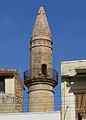
Valide Sultana Mosque


Secular buildings
- Fortezza
- The Venetian fortifications, located above the city of Rethymno, on the Paleokastro (Παλαιόκαστρο) hill on the northern peninsula west of the port, is still called Fortezza (Φορτέτζα) after the Italian name for 'fortress' . It was planned by the architect Sforza Pallavicini after an Ottoman attack on July 7, 1571 by Uludsch Ali Pascha (Ουλούτζ Αλή, Italian Occhiali ) on behalf of the governor ( Rettore 'Rector') Alvise Lando and after the laying of the foundation stone on September 13, 1573 It was largely built by 1578 under the direction of the civil engineer Gian Paolo Ferrari , but after many changes it was not completed until 1590. Initially, it was planned to move the entire Venetian city of Retimo behind the walls of the Fortezza , which was not carried out due to the insufficient area within the fortress walls.
- Under the Venetians, the fortress was the seat of administration, military authorities and Roman bishops, and served as a refuge for the city's population. After Retimos was conquered by the Ottomans on September 29, 1646 and the fortress surrendered on November 13, 1646, the Fortezza , which was handed over intact, was expanded further. The 'upper town' located within its walls was mainly inhabited by Turks or by Cretans who had converted to Islam from this time on. Today, of the inner buildings, in addition to the remains of the Cathedral of San Nicolo , which was dedicated to St. Nicholas , and some of the guardhouses, only the domed structure of the Sultan Ibrahim Mosque , built on the ruins of the cathedral from 1646, remains . After independence from the Ottomans, the minaret of the mosque on its west side was demolished. The dome has recently been restored and, from the inside, freed from any plastering, offers the visitor an open view of its stone construction.
- loggia
- The Loggia of Rethymno (Η Loggia του Ρεθύμνου) is a representative single-storey building designed in the 16th century by the architect Michele Sanmicheli in the center of the old town, which served as a meeting place for the Venetian upper class. It has a square floor plan, was built with regular large stones and has three round arches on each side, with the exception of the west side, through the middle of which the building could be entered. The originally open building is now closed by glass fronts and is used as an exhibition and sales room for the Ministry of Culture for works of art and their copies, including original casts and replicas of ancient sculptures. From 1954 to 1991 the archaeological museum was housed in the loggia
- Porta Guora (Megali Porta)
- The Porta Guora (Πόρτα Guora 'Guora Gate'), usually called Megali Porta (Μεγάλη Πόρτα 'Great Gate'), is one of the few remains of the former city fortifications from the 16th century. The Megali Porta was the most important of the three gates of Rethymno, next to it there were only two other gates, the west gate, which was only used for military purposes, and the east-facing gate "Porta Ammou". The preserved archway of the southern city gate is on the edge of the former Venetian old town as access to its main street, the Odos Ethnikis Andistaseos ('Street of Popular Resistance') on the Platia of the same name. The Megali Porta was built in the course of the expansion of the settlement between 1540 and 1570 based on plans by the Venetian architect Michele Sanmicheli in pilasters and was named after the governor ( Rettore 'Rector') Jocopo Guoro, who was in office during the construction of the gate from 1566 to 1568 .
- Originally, the 2.60 meter wide archway was adorned with a gable adorned with the Venetian coat of arms, the Lion of St. Mark , whose relief is now in the Archaeological Museum. The gable with the lion pointed north towards the city, the archway that has survived to this day was only the inner exit of a large gate system 27 meters deep, which emerged from the line of the city wall to the south in the form of a bastion. This gate system was still completely preserved at the beginning of the 20th century, as can be seen in photos by the Italian photographer Giuseppe Gerola . In 1902 the large city gate was torn down "for the good of the city". Its popular name was carried over to the rather small archway that is still preserved today.
- Rimondi fountain
- In the former center of the Venetian Retimo , at the northern end of Petychakis Square (also Platanos Square ), is the fountain, first built in 1588, later the Rimondi Fountain (Κρήνη Rimondi). It got its name from the governor ( Rettore 'Rector') Alvise Rimondi, who had the fountain renewed in 1626. Public wells of this type once served to supply city residents with water.
- Between the four columns of the Rimondi fountain with their Corinthian capitals, water flows from three openings in the shape of lions' heads into the collecting basins below. On a frieze above the column capitals, the fragmented inscription "... IACÆ LIBERALITATIS FONTES IN ..." can be read in Latin letters. A dome built by the Ottomans over the fountain was destroyed in World War II.


Parks
- City garden
- To the southwest of Tessaron-Martyron-Platz is the 'City Garden' (Δημοτικός Κήπος) of Rethymno on Igoumenou-Gavril-Straße . The 25,000 m² city park south of the old town was laid out at the beginning of the 20th century on the site of the former Turkish cemetery. In the park there are a number of stone busts of Cretan and Greek personalities, a children's playground and a restaurant.
- Natural park
- About two kilometers southeast of the city center, on the Kalaitzaki to Kastellakia road (Καστελάκια), there is the Biotopi Nature Park (ΒΙΟΤΟΠΟΙ), which is dedicated to the preservation and presentation of Cretan flora and fauna. The park's ecosystem provides a habitat for around 220 native plant species as well as for various reptiles, amphibians, birds, insects and fish. Guided hiking tours through the park are offered for visitors.
Regular events
- Karnevali
- Rethymno is considered the city of carnival in Crete , but not as common in Orthodox Greece as it is in Catholic regions. The Rethymnian Carnival dates back to the first humorous celebrations in 1914 after Crete was annexed to Greece. The highlight of the carnival in Rethymno is the Sunday before Shrove Monday with a large parade of floats and street carnival in the city center, which is closed to traffic. On the previous Saturday evening there is an atmosphere comparable to the dirty Thursday of the Alemannic Carnival . Rose Monday ( Greek καθάρη δευτέρα Kathari Deftera , 'Clean Monday'), on the other hand, is considered the beginning of Lent in Greece and is celebrated with meatless meals in the open air and kite flying (for Greek Carnival see also Patras ).
- Renaissance festival
- The Renaissance Festival has been held in Rethymno every year in late summer since 1987 . Theatrical and musical works with a background from the Renaissance era are performed in the Erofili amphitheater on the Fortezza, and scenes from the Commedia dell'arte are presented in the streets of the old town .
Economy and Infrastructure

Rethymno is fighting with Chania for the title of the most beautiful city in Crete. Tourism, for which around 19% of the community's working population work, is of the greatest economic importance. Attractions are the old town with its picturesque streets, sights such as the Venetian fortress and numerous restaurants and bars. The kilometer-long sandy beaches with gently sloping water to the east of the city, which extend as far as Skaleta in the neighboring municipality of Arkadi, and which together with it are developed for mass tourism , make up the majority of the around 2,800 beds in 143 hotels and guest houses. Around four fifths of the tourists come from abroad, but the proportion of Greek guests is rising steadily. The increasing attractiveness of the municipality for congress, sport, cultural and agrotourism increases the proportion of short stays in the city.
traffic

Rethymno's importance for the national traffic lags behind that of the cities of Chania and Heraklion. The connection to national and international air traffic is via the airports of Chania (around 70 kilometers to the west) and Heraklion (80 kilometers to the east). From 1991 to 2008 there was a ferry connection from the port of Rethymno to Piraeus , but international ferry traffic is handled via Souda near Chania and Heraklion, which have larger port facilities. In view of the increasing importance of such transport infrastructures for tourism, the city government is trying to improve the connections to the city, possibly with a new speedboat connection to Piraeus. The ANEK and NEL ferry routes from Piraeus to Rethymno were both discontinued in autumn 2008. As yet (January 2009) there is no resumption in sight - even for the summer. The city council is negotiating with the shipping companies.
Since Crete does not have a railway network, roads are the only important inner-Cretan transport routes. Rethymno is located on Crete's only motorway-like connection, the national road 90, which follows the north coast of Crete and connects the four prefecture capitals of the island. Bus lines operated by the local public transport company KTEL run here at least every hour between the major cities during the day. The N 90 also delimits the city center to the south. Furthermore, the national road 97 connects Rethymno with the Cretan south coast and further with the Messara plain to Ierapetra , the villages of the communities Finikas and Lambi can also be reached via branches from this road . A winding country road running parallel to the east leads on the southern slope of Psiloritis through the Amari basin via Fourfouras to Agia Varvara .
education

Rethymno is the seat of three of the five faculties of the University of Crete , which began teaching in 1977. The university campus was built about three kilometers southwest of the old town at about 160 meters above sea level (coordinates: 35 ° 21 ′ 13 ″ N , 24 ° 27 ′ 0 ″ E ). This was preceded by a political dispute about the location of the newly founded university. Shortly before his overthrow, the dictator at the time Georgios Papadopoulos had promised one of his favorites, who came from Rethymno, his hometown as the location, so that in 1973 Rethymno became the formal seat of the institute. After protests by the island's capital, Heraklion, and a dispute that lasted for years, the decision was made to distribute the faculties between the two cities of Heraklion and Rethymno. Today around 7,000 students study in Rethymno, primarily in the humanities and social sciences.
nature
- Myli Gorge : From Rethymno to Chromonastiri there are excursion buses to the Myli Gorge . Along the hiking trail through the approximately 4 km long gorge, away from the crowds of tourists, you can spend a pleasant time in the largely untouched nature.
sons and daughters of the town
- Markos Mousouros (around 1470-1517 ), scholar and humanist
- Zacharias Kallergis (* around 1473), scholar, typographer and draftsman
- Georgios Chortatzis (around 1550 - around 1610), playwright and author
- Athanasios Patelaros (1597-1654), Greek Orthodox Metropolitan, as Athanasios III. Patelaros 1634 Patriarch of Constantinople
- Emmanouil Lomvardos (around 1600 - around 1650), painter - representative of the "Cretan School"
- Emmanouil Tzane Bounialis (1610–1690), painter - representative of the "Cretan School"
- Ahmed İbrahim Resmî (1694 / 1695–1783), Ottoman statesman and diplomat
- Emmanouil Tsouderos (1882–1956), politician
- Pandelis Prevelakis (1909–1986), writer who set a literary monument in his hometown with the novel Chronicle of a City
- Stylianos Pattakos (1912–2016), former Greek military and politician
- Nikos Mamangakis (1929–2013), composer
- Vardis Vardinogiannis (* 1933), shipowner and entrepreneur
- Stylianos Harkianakis (1935–2019), Archbishop of the Greek Orthodox Archdiocese of Australia
- Evangelos Apostolakis (* 1957), Admiral and Minister of Defense
- Andreas Xanthos (* 1960), politician (SYRIZA), Minister of Health
- Konstantinos Chatzidakis (* 1965), politician
- Sofia Asoumanaki (* 1997), rower
Cadastre
Some areas of this municipality are included in the cadastral system and belong to the authority of the land registry office of Rethymno, namely: the area and suburbs of the city of Rethymno since March 12, 2012, Adele since May 18, 2006, Argyroupoli since March 28, 2005, Armeni and Somatas since September 15, 2005, Atsipopoulo since January 3, 2006, Gerani since March 28, 2005, Episkopi , Archondiki , Koufi and Karoti since July 21, 2005, Maroulas since July 21, 2005, Prasies since July 7 2005, Prines since October 6, 2005, Roussospiti since July 21, 2005, Chromonastiri , Myli and Kapediana since July 7, 2005.
literature
- Pandelis Prevelakis: The Chronicle of a City . Suhrkamp, Frankfurt 1981 (Greek original edition 1938; story).
- Stella Kalogeraki: Rethymnon. The soul of Crete . Mediterrano Editions, 2002, ISBN 960-8227-15-1 (travel guide).
- Stella Kalogeraki: Fortezza. Rethymno Castle . 2nd Edition. Mediterrano Editions, Rethymno 2000 (richly illustrated guide through the Venetian fortress).
- Alkmini Malagari, Charis Stratidakis: Rethymno: A guide to the city and the administrative district . 4th edition. Athens 1994 (somewhat older travel guide, which offers a wealth of interesting details, for example on economic development or history).
- Charidimos Andrea Papadakis (Ed.): Rethymno. Ta Chasapiá tou Rethymnou kai oxi mono ( τα Χασαπιά του Ρεθύμνου και όχι μόνο "The 'butcher's market' Rethymnos and not just that") . Rethymno 2005, ISBN 960-87870-1-7 (building and social history collection on the history of Rethymno over the past 100 years).
- Andreas F. Kelletat: The hero of Rethymnon. From the papers of the paratrooper Kuno Sottkowski . Edition Noack & Block, Berlin 2017, ISBN 978-3-86813-051-5 (novel).
Web links
- Rethymno (city)
- Archaeological Museum Rethymno ( Memento from May 23, 2009 in the Internet Archive )
- History and Folklore Museum Rethymno
- Rettimo (English)
- Arkadi tourist guide , accessed April 9, 2012.
- Website of the Rethymno Prefecture Tourism Promotion Committee; Retrieved April 9, 2012.
Individual evidence
- ↑ a b c Results of the 2011 census. ( Memento from June 27, 2015 in the Internet Archive ) ( Excel , 2.6 MB) National Statistical Service of Greece (ΕΛ.ΣΤΑΤ)
- ↑ Geological origin and development (former website: www.evai.de/pages/info_klima.htm)
- ↑ G. Desipris, K. Santorineou: Rethymno. Toubis, 1997.
- ↑ Lambert Schneider: Kreta , Dumont art travel guide, p. 18.
- ↑ Population of Rethymno 1940–2001, Greek Statistical Office ELSTAT, digital library (Greek and English)
- ↑ Climate Crete ( Memento from October 1, 2008 in the Internet Archive )
- ↑ Geography-Climate
- ↑ To the cave of Gerani (II). (PDF; 290 kB) April 27, 2008, accessed February 8, 2012 .
- ↑ Rethymno - History
- ^ Rhithymna . In: Wiliam Smith (Ed.): Dictionary of Greek and Roman Geography . London 1854 ( full text ).
- ↑ a b Rethymno - The ancient Rithymna
- ↑ Kreta-reisen.de ( Memento from September 27, 2007 in the Internet Archive )
- ↑ a b Rethymno - Byzantine times and Venetian rule
- ↑ Corsari del Mediterraneo: Enrico Pescatore (Enrico il Pescatore) ( Memento of the original of May 10, 2006 in the Internet Archive ) Info: The archive link was inserted automatically and has not yet been checked. Please check the original and archive link according to the instructions and then remove this notice.
- ↑ Carmen Galenschovski: Kreta , Baedeker 2005, ISBN 3-8297-1089-5 , p. 260.
- ↑ Emanuela Guidoboni, Alberto Comastri: The large earthquake of 8 August 1303 in Crete: seismic scenario and tsunami in the Mediterranean area. In: Journal of Seismology. 1, 1, 1997, pp. 55-72, doi: 10.1023 / A: 1009737632542 .
- ↑ a b c d Rethymno - The catastrophe of 1571 and the Cretan Renaissance
- ↑ Crete - History / Mythology (PDF; 104 kB)
- ↑ Η Πύλη Guora - Αρχαιολογικοί χώροι στο Ρέθυμνο
- ↑ Klaus Bötig , Otto Gärtner: Crete. dtv, Munich 1993, p. 210.
- ↑ Lambert Schneider: Kreta , Dumont art travel guide, p. 258 f.
- ^ A b Joseph von Hammer: History of the Ottoman Empire. Third volume. Hartleben's, Pesth 1835, p. 287.
- ↑ Rethymno - The Siege of Rethymno
- ^ Edgar Hösch : Half moon over Europe - The Ottomans. In: The great world history. Volume 8. Licensed edition Verlagsgruppe Weltbild, Bibliographisches Institut & F. A.Brockhaus, p. 42.
- ↑ Joseph von Hammer: History of the Ottoman Empire. Third volume. Hartleben's, Pesth 1835, p. 632.
- ↑ Sabine Neumann, Horst Schwartz: Crete . In: DuMont Travel correctly . 2nd Edition. DuMont, Cologne 1995, ISBN 3-7701-3445-1 , p. 194 (320 p., Limited preview in Google Book search).
- ^ Rethymno - Autonomy-Union-Modern Times
- ^ Election result ( memento of May 26, 2009 in the Internet Archive ) on the website of the Greek Ministry of the Interior.
- ↑ Historical and Folklore Museum
- ↑ a b Museums in Rethymno
- ↑ "Ta chasapia ..." S. 180th
- ^ Retimo - Joseph Pitton de Tournefort, Paris.
- ↑ Ναός Τεσσάρων Μαρτύρων (Church of the Four Martyrs)
- ↑ History - The fall in 1571 and the Cretan Renaissance ( Memento of the original from May 31, 2009 in the Internet Archive ) Info: The archive link was automatically inserted and not yet checked. Please check the original and archive link according to the instructions and then remove this notice.
- ↑ The fortification of Rethymno
- ↑ The Fortezza of Rethymno
- ^ Rethymno - The public buildings
- ^ Andreas Schneider: Crete. DuMont, Ostfildern 2009, p. 217.
- ↑ 1. Rethymno - The fortification of Rethymno 2. Χαρίδιμος Ανδρέα Παπαδάκις Τα Χασαπιά του Ρεθύμνου και όχι μόνο , Ρέθυμνο 2005.
- ↑ G. Desipris, K. Santorineou: Rethymno. Toubis, 1997, p. 77.
- ^ Sabine Neumann, Horst Schwarz: Kreta. Dumont, ISBN 978-3-7701-3445-8 .
- ↑ Website of the Rethymno municipality: rethymno.gr accessed on July 19, 2018
- ^ Municipal website of the Carnival of Rethymno (Greek)
- ^ Press release of the city of Rethymno from February 6, 2007
- ↑ Daily newspaper "Ρεθυμιοτικη"
- ^ Greek cadastral areas. (No longer available online.) Ktimatologio SA, archived from the original on March 29, 2012 ; Retrieved September 4, 2012 . Info: The archive link was inserted automatically and has not yet been checked. Please check the original and archive link according to the instructions and then remove this notice.