Souda
|
Souda parish Δημοτική Ενότητα Σούδας (Σούδα) |
||
|---|---|---|
|
|
||
| Basic data | ||
| State : |
|
|
| Region : |
Crete
|
|
| Regional District : | Chania | |
| Municipality : | Chania | |
| Geographic coordinates : | 35 ° 29 ′ N , 24 ° 4 ′ E | |
| Height above d. M .: | 25 m (average) |
|
| Area : | 22.007 km² | |
| Residents : | 8,442 (2011) | |
| Population density : | 383.6 inhabitants / km² | |
| Code No .: | 740107 | |
| Structure: |
1 city district 2 local communities |
|
| Located in the municipality of Chania and in the regional unit of Chania | ||
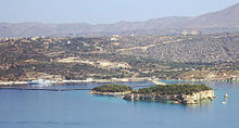
Souda ( Greek Σούδα ) is a municipality in Crete and has belonged to Chania since the administrative reform in 2010 . The Souda Bay is one of the deepest natural harbors of the Mediterranean and easy to defend. It is enclosed to the north by the Akrotiri peninsula . Today there is an important ferry port and naval base with a NATO base. In addition, an islet in the bay bears the same name and the military part of Chania Airport is known as Souda Air Base .
location
Souda is 6.5 kilometers east of the center of Chania in a densely populated area. Today Souda is the dock for ferries from Piraeus . A grain silo towers over the city skyline.
structure
The district of Souda (6418 inhabitants) is the main town of the district with the town hall , to which the eastern village of Platani belongs. In the hinterland is the local community Tsikalaria (1545 inhabitants), on the coast east the local community Aptera (479 inhabitants) with the settlements Aptera and Kalami.
history

The place is relatively young. Under Turkish rule, Souda was known as Tuzla , the Turkish name for brine basin . The settlement was therefore mainly built on salt marshes.
On June 14th and 15th, 1825, the Battle of Souda took place between the Ottomans and the Greeks during the Greek Revolution . Around 1870 the place began to grow while the port gained importance.
During the Second World War , Souda was one of the most important targets for the occupation of the island in the airborne battle for Crete (" Operation Mercury ") from May 20 to June 1, 1941.
On March 26, 1941, the British cruiser HMS York and the Norwegian tanker Pericles were rendered inoperable by Italian explosives during the attack on Souda Bay and sunk a few days later by a German air raid.
Attractions
Souda is not a tourist center. On the shore of the bay on the land bridge to the Akrotiri Peninsula is the Souda Bay War Cemetry (war cemetery in Souda Bay) with graves of mostly English , New Zealand and Australian soldiers from the Second World War . The archaeologist John Pendlebury is also buried in this cemetery, who was the curator of the British School in Athens in Knossos and who continued the excavations during the Second World War.
Other facilities
The Academy of the Greek Merchant Navy is also located on the south bank of the bay. There is also a marine hospital near the ferry port.
Web links
Individual evidence
- ↑ a b Results of the 2011 census at the National Statistical Service of Greece (ΕΛ.ΣΤΑΤ) ( Memento from June 27, 2015 in the Internet Archive ) (Excel document, 2.6 MB)


