San Polo
San Polo is one of the six districts of Venice . It is located southwest of the Grand Canal in the great loop formed by it. The sestiere (sixth) derives its name from the ancient church of San Paolo Apostolo . This church was formerly assigned its own parish ; today it belongs to the municipality of Santa Maria Gloriosa dei Frari . The sestiere had eight contrade (parishes) in 1171 ; by 1586 the number rose to nine.
In 2009, San Polo had a population of 5022, divided between the parishes of San Silvestro (with San Giacometto), San Cassiano (with Santa Maria Mater Domini) and Santa Maria Gloriosa dei Frari (with San Polo and San Rocco).
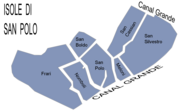
The population is distributed across the seven individual islands as follows:
| island | Area ha |
Population 2009 |
belongs to the parish |
Remarks |
|---|---|---|---|---|
| Frari | ... | 1296 | Santa Maria Gloriosa dei Frari | with San Rocco |
| Meloni | ... | 275 | San Silvestro | |
| Nomboli | ... | 459 | Santa Maria Gloriosa dei Frari (formerly San Polo) | |
| San Boldo | ... | 377 | Santa Maria Gloriosa dei Frari | |
| San Cassiano | ... | 843 | San Cassiano | |
| San Polo | ... | 454 | Santa Maria Gloriosa dei Frari (formerly San Polo) | |
| San Silvestro | ... | 1318 | San Silvestro | with San Giacometto |
| Sestiere San Polo | 34 | 5022 | 3 parishes |
The sestiere is the smallest in the city with around 34 hectares, but within its limits it contains the oldest part of Venice and the second largest square, the Campo San Polo .
The centerpiece is the Rialto with the Mercato di Rialto , the city's commercial center. The name is derived from rivo alto (dt. High bank) and at the beginning of the urban development comprised a group of islets, the Isole Rialtine , which formed their center around the Rio Businiaco. This part of the city was also the site of the first seat of government in the 9th century, which was moved here from Malamocco . After the night of the fire on January 10, 1514 , hardly anything remained of the original buildings, with the exception of the Church of San Giacometto .
from San Polo
See also
- Republic of Venice
- Economic history of the Republic of Venice
- Bridges in Venice
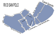
- Canali, Rii, waterways in Venice
literature
- Jean-François Chauvard: Pour une histoire dynamique de la propriété venitienne. L'exemple de la paroisse de San Polo (XVIIe-XVIIIe siècles) , in: Mélanges de l'Ecole française de Rome. Italie et Méditerranée 111.1 (1999) 7-72.
- Joseph Wheeler: The Sestiere of San Polo. A Cross Section of Venetian Society in the Second Half of the Fifteenth Century , thesis, Warwick University, 1995.
Individual evidence
- ↑ COMUNE DI VENEZIA statistics
- ↑ Page no longer available , search in web archives: PDF at alga.provincia.venezia.it
Coordinates: 45 ° 26 ′ 15 ″ N , 12 ° 19 ′ 47 ″ E


