
Agia Roumeli
|
Local community Agia Roumeli Τοπική Κοινότητα Αγίας Ρουμέλης (Αγία Ρουμέλη) |
|||
|---|---|---|---|
|
|||
| Basic data | |||
| Country |
|
||
| region | Crete | ||
| Regional district | Chania | ||
| local community | Sfakia | ||
| Geographic coordinates | 35 ° 14 ' N , 23 ° 58' E | ||
| Height above d. M. |
12 m |
||
| surface | 94.941 km² | ||
| Residents | 57 (2011) | ||
| Population density | 0.60 inhabitants / km² | ||
| Local division | 1 (inhabited) settlement | ||
 |
|||

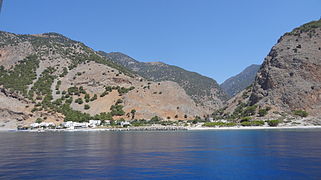
Agia Roumeli ( Greek Αγία Ρουμέλη ( f. Sg. )) Is a port on the southwest coast of Crete on the Libyan Sea . Administratively it belongs to the municipality of Sfakia in the regional district of Chania . Agia Roumeli can only be reached by water or hiking trails. Among other things, the European long-distance hiking trail E4 connects the place with Sougia in the west and Loutro in the east. The village is known as the end point of the 16 kilometer hike from the Omalos plateau through the longest gorge in Europe, the Samaria Gorge , down to the sea. During the main hiking season in summer, the small town, once just an isolated fishing village, is the destination of thousands of day-trippers. After the hike, you will be taken from here by ferry to the west in the direction of Sougia and Paleochora or east to Chora Sfakion in order to get back to your holiday domicile in the north of the island. In the village there is a first aid station, several smaller hotels, restaurants, bars and two supermarkets and souvenir shops. A helipad is maintained on the flood plain east of the village.
Few people live in the village outside of the season. The 2011 census recorded 57 people registered in Agia Roumeli. In fact, around 30 to 40 people live in the village in winter. The supply is maintained via a ferry service twice a week.
Palea Agia Roumeli
About two kilometers into the gorge lies the original settlement of Agia Roumeli, today called Palea Agia Roumeli (Παλεά Αγία Altουμέλη, Old-Agia-Roumeli '). In 1952 the village was badly damaged by a flood. After the establishment of the national park and the new village at the port, the place became orphaned. Comprehensive repair work has been taking place since autumn 2008. The eponymous church and the cemetery - also for the new village - are still at the old site.
history
Once founded by the Dorians as Tarrha , the city fell into disrepair since 500 AD. Excavations bear evidence of Roman traces. It is possible that there was a port here before, in Minoan times. The mosaics of a temple of Apollo date from the Hellenistic- Roman times , in the place of which today the Panagia church from the Venetian period stands on a smaller floor plan . The mosaics in front of the church are accessible to everyone, the church itself is usually locked. During the various times of occupation by the Venetians and Ottomans , the impregnable Samaria Gorge repeatedly served as a gathering point for the insurgents. So also in 1770 under Jannis Daskalogiannis and during the great Cretan uprising in 1886. Agia Roumeli as the southern exit of the gorge with direct access to a navigable port was therefore of great strategic importance for the occupiers at all times.
Agia Roumeli and the Samaria Gorge

Agia Roumeli village and port

Turkish castle ruins above Agia Roumeli


After the final suppression of the uprisings in 1887, the Ottomans therefore built various fortifications there. The ruins of a castle, which was used to monitor the gorge exit, have been preserved on the ridge at a height of 200 meters north of Agia Roumeli. It can be reached from the south via a serpentine path. A path leads north along the slope to Alt Agia Roumeli. A poorly preserved path leads from the castle to another ruin at a height of 530 meters, which probably belonged to an observation tower.
Web links
Individual evidence
- ↑ National Statistical Service of Greece (ΕΣΥΕ) according to 2001 census , p. 124 (PDF, 793 kB)
- ↑ a b Results of the 2011 census at the National Statistical Service of Greece (ΕΛ.ΣΤΑΤ) ( Memento from June 27, 2015 in the Internet Archive ) (Excel document, 2.6 MB)
- ^ Klaus Gallas : Crete. From the beginnings to Crete-Venetian art . DuMont, Cologne 1987, p. 264.
- ↑ Hanni Guannella: Crete . Theological Verlag Zurich 1982, ISBN 3-290-11484-8 , p. 338.
- ↑ Eberhard Fohrer: Crete . Michael Müller Verlag, Erlangen 2007, pp. 688f.