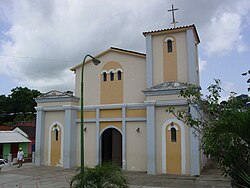
Chuspa
| Chuspa | ||
|---|---|---|
|
Coordinates: 10 ° 37 ′ N , 66 ° 19 ′ W Chuspa on the map of Venezuela
|
||
| Basic data | ||
| Country | Venezuela | |
| State | Vargas | |
| - in the metropolitan area | 3,918 | |
| Detailed data | ||
| Waters | Caribbean Sea | |
| Post Code | 1166 | |
| prefix | 0231 | |
| Time zone | UTC -4: 30 | |
Chuspa is a village in the Venezuelan state of Vargas . The village is mainly a fishing village that also attracts tourists. It is connected to La Guaira and Higuerote , in the state of Miranda , by a coastal road.
history
The village is on the bank of the Chuspa River. The conquistador Francisco Fajardo arrived here from Margarita in 1555 to conquer the region. During the colonial period, cocoa was grown in the Chuspatal. In the 17th century, more and more black slaves came to work in the plantations. In the second decade of the 18th century, the Chusparegion had around 200,000 cocoa trees.
On November 18, 1813, between Puerto Francés and Chuspa, a sea battle took place between the independence army led by Manuel Piar and the royalists. Manuel Piar defeated the Spaniards.
Infrastructure
tourism
There is a small harbor for fishermen's boats and for small tourist companies. You can also find several hostel and restaurants. In front of Chuspa itself there is a 230 meter long beach.
A boat can be rented from the village to travel to beaches like Caribe, Los Indios, Capino and Mono Manso in the state of Miranda in around 10 minutes.
Education and culture
Chuspa has a school and kindergarten. There is also a public library.
Others
There is an internet café .
Individual evidence
- ^ Ferry, Robert (1989): The colonial elite of early Caracas: formation and crisis, 1567-1767 . Page 211.
- ↑ Piar (in Spanish)
Web links
- History of Chuspas (Spanish) (PDF; 1.3 MB)
- Chuspa (Spanish)
- Caruao, population estimate
- National Geographic coordinates

