
Cima Capi
| Cima Capi | ||
|---|---|---|
 Cima Capi recorded from the Cima Rocca |
||
| height | 909 m slm | |
| location | Trentino , Italy | |
| Mountains | Garda mountains | |
| Coordinates | 45 ° 52 '10 " N , 10 ° 49' 43" E | |
|
||

The Cima Capi is a well-traveled, 909 m slm high summit in the Lake Garda mountains , which can be reached via a via ferrata route.
location
The summit is part of the Rocchetta massif, which lies north of the Val di Ledro and west of the northern part of Lake Garda . The neighboring summit is the Cima Rocca ( 1089 m slm ) in the northwest .
Via ferrata route
Starting points for the via ferrata tour are both Riva del Garda ( 78 m slm ) and Biacesa di Ledro ( 418 m slm ). The path leads through war tunnels and past trenches that were created during the First World War ( mountain war 1915–1918 ). It also offers a view of Lake Garda and the eastern Lake Garda mountains. The route consists of four via ferrata: Sentiero Susatti, Sentiero Foletti, Sentiero Camminamenti, Sentiero delle Laste. The degree of difficulty ranges from easy (K1-2) to medium (K2-3) on the Hüsler scale .
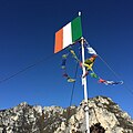
Flag on the summit
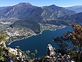
View from the summit of Lake Garda
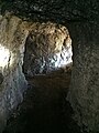
War tunnel near the Cima Capi


Web links
- Via ferrata tour to Cima Capi on outdooractive.com - accessed on January 21, 2017
- Map at peakhunter.com - accessed January 21, 2017
Individual evidence
- ↑ Eugen E. Hüsler: Hüsler's via ferrata guide Lake Garda . Bruckmann Verlag, 2012, ISBN 978-3-7654-5937-5 , p. 62 ff .