Cima della Cengia delle Pecore
| Cima della Cengia delle Pecore | ||
|---|---|---|
|
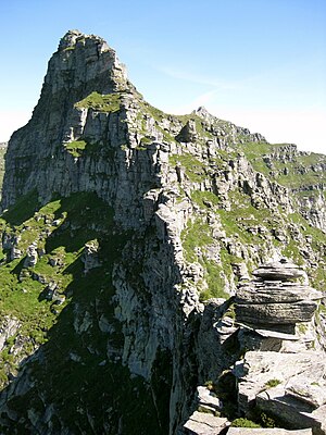
View of the Cima della Cengia delle Pecore |
||
| height | 2393 m above sea level M. | |
| location | Switzerland | |
| Mountains | Lepontine Alps | |
| Coordinates | 713 575 / 124539 | |
|
|
||
The Cima della Cengia delle Pecore (on older maps also Cima del Scengio delle Pecore ) is 2393 m above sea level. M. high peak in the Lepontine Alps in the Swiss canton of Ticino .
location
The summit lies between the Val Carecchio , a side valley of the Verzasca valley in the west and the Val Drosina , a side valley of the Val di Lodrino , which in turn is a side valley of the Riviera , in the east. The municipal boundary between Lavertezzo and Riviera , previously Lodrino , also leads over the summit . Around 770 meters northeast on the ridge is the Cima di Picoll ( La Scíma do Picóll ) ( 2439 m above sea level ) and around 1.4 kilometers south-east of the 2439 m above sea level. M. high Poncione di Piotta ( El Ponción Piòta ).
Alpe Picoll and Alpe Piotta , on which the right source stream of the Lodrino , the Drosina rises, are located on the eastern slope, a little below the summit . On the south-western slope there is a short valley of a source brook of the Riale Carecchio and on the north-western slope there is the valley of the Gared , which also flows into the Riale Carecchio.
Individual evidence
- ↑ Geoserver of the Swiss Federal Administration ( information )

