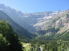
Cirque de Gavarnie
The Cirque de Gavarnie is a rocky basin in the Pyrenees National Park . It is considered an impressive natural experience. It is right on the border with Spain and in the area of the municipality of Gavarnie . The basin has a diameter of about two kilometers and is about 1700 meters above sea level. The surrounding mountains tower more than 1500 meters above the bottom of the basin.
The rock basin
In the valley of the almost vertical rock face are the Gavarnie Falls , which are among the highest waterfalls in Europe (total height of 422 m). They arise from an underground glacial lake in the mountains and, due to their amount of water, form one of the most important source streams of the Gave de Pau .
In 1997, the Cirque de Gavarnie with the entire mountain group was Pyrénées-Mont Perdu from the UNESCO in the World Heritage List was added. The name comes from Gascon and is derived from the term Gave (see French Wikipedia).
geology
The Gavarnie region is of Ice Age origin. Gray calcareous soils, ocher and pink, have been lifted up to 3,000 meters due to the displacement of the plates. A special feature is the 40 m wide Bergscharte Bresche von Roland .
tourism
The Cirque de Gavarnie is used intensively for tourism. Donkey paths (including donkeys that can be rented) and extensive hiking trails run through the area, which is accessible from above and from the valley, in the lower area car-free for the last few kilometers. The region has been described euphorically by many writers, e. B. by Henry Miller in Land of Memories .
literature
- Patricia Corrigan: Waterfalls . Chelsea House Publications, 2007, ISBN 978-0-8160-6436-6 , pp. 44-54 . ( Excerpt in the Google book search)
Web links
Coordinates: 42 ° 41 ′ 42 ″ N , 0 ° 0 ′ 32 ″ W.
