Colbeck Bay
| Colbeck Bay | ||
|---|---|---|
|
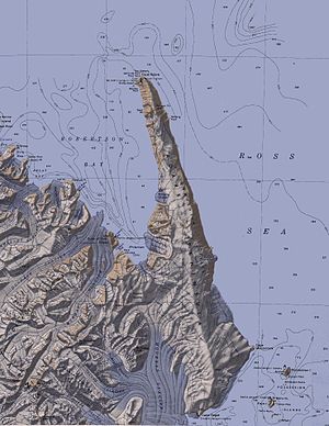
Colbeck Bay in the southwest of Robertson Bay (center left) west of the Adare Peninsula |
||
| Waters | Robertson Bay | |
| Land mass | Victoria Land , East Antarctica | |
| Geographical location | 71 ° 38 ′ 0 ″ S , 170 ° 5 ′ 0 ″ E | |
|
|
||
The Colbeck Bay is a bay on the Pennell Coast of the East Antarctic Victoria Land . It is located between Cape Kløvstad and the Duke of York Island in the southern part of Robertson Bay .
It was mapped by participants in the British Southern Cross Expedition (1898–1900) led by the Norwegian polar explorer Carsten Egeberg Borchgrevink . Borchgrevink named it after William Colbeck (1871-1930), an officer in the Royal Navy and member of the expedition.
Web links
- Colbeck Bay in the Geographic Names Information System of the United States Geological Survey (English)
- Colbeck Bay on geographic.org (English)

