
Pennell coast
| Pennell coast | ||
|---|---|---|
|
||
| location | Victoria Land , East Antarctica | |
| Waters | Somow Lake and Robertson Bay ( Southern Ocean ) | |
| From |
Cape Williams 70 ° 30 ′ 0 ″ S , 164 ° 9 ′ 0 ″ E |
|
| To |
Cape Adare 71 ° 20 ′ 6 ″ S , 170 ° 8 ′ 23 ″ O |
|

Coordinates: 71 ° 0 ′ S , 167 ° 0 ′ E
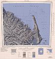
The Pennell Coast is a stretch of coast between Cape Williams and Cape Adare in East Antarctic Victoria Land . In the south and east, beyond Cape Adare, joins the Borchgrevink coast , and in the west the Oates coast .
The name was recommended in 1961 by the New Zealand Place Name Commission for the Antarctic (NZ-APC) in memory of Harry Pennell (1882-1916). He was in command of the Terra Nova , the expedition ship of the Terra Nova Expedition (1910-1913). Pennell carried out oceanographic work in the Ross Sea . In February 1911 he explored this stretch of coast after he had set off the northern group of the expedition under Victor Campbell (1875-1956) at Cape Adare.
The name Pennell Coast stands for both the coastline itself and the hinterland southwards to the watershed at the Southern Cross Mountains and westwards to the Usarp Mountains .
The Pennell Coast area is home to the 250-kilometer-long Rennick Glacier , the Anare Mountains and the northern foothills of the Bowers Mountains and the Admiralty Mountains . The inland is defined by numerous smaller mountain ranges, including the Freyberg Mountains and the Concord Mountains .

Western part with Ob 'Bay (1967)

Middle section with Yule Bay (1968)
Eastern part with Robertson Bay (1968)


Web links
Individual evidence
- ^ John Stewart: Antarctica - An Encyclopedia . Vol. 2, McFarland & Co., Jefferson and London 2011, ISBN 978-0-7864-3590-6 , pp. 1198 f. (English)