
Rennick Glacier
| Rennick Glacier | ||
|---|---|---|
| location | Victoria Land , East Antarctica | |
| Mountains | Transantarctic Mountains | |
| length | 320 km | |
| width | Max. 48 km | |
| Coordinates | 70 ° 30 ′ S , 160 ° 45 ′ E | |
|
||
| drainage | Rennick Bay | |

The Rennick Glacier is a nearly 320 km long and up to 48 km wide glacier in the East Antarctic Victoria Land , which is one of the largest glaciers in Antarctica . It flows from the polar plateau , where it reaches its greatest width, to Rennick Bay on the Oates coast , where it narrows to about 15 km and drains into the Somow Sea .
The lower section of the glacier was photographed during Operation Highjump (1946–1947). In the early 1960s evacuated Lieutenant Commander Robert L. Dale, a pilot of Flugerstaffel VX-6 of the US Navy , an investigation team of the United States Antarctic Program of the glacier surface at 72 ° 38 ' S , 161 ° 32' O . It is named in connection with the bay of the same name after Henry Edward de Parny Rennick (1881-1914), a ship officer on the Terra Nova in the expedition named after this (1910-1913) under the direction of the British polar explorer Robert Falcon Scott .
Web links
- Rennick Glacier in the Geographic Names Information System of the United States Geological Survey (English)
- Rennick Glacier on geographic.org (English)

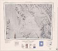
Map sheet Ob 'Bay from 1967, northeast part of the Rennick Glacier on the western edge of the map

Map sheet Mount Soza from 1967, middle part of the Rennick Glacier in the west of the map
Map sheet Freyberg Mountains from 1967, southern part of the Rennick Glacier in the west of the map

Map sheet Pomerantz Tableland with the northwest part of the Rennick Glacier


