Cooley Peninsula
| Cooley Peninsula | ||
 Carlingford on the Cooley Peninsula |
||
| Geographical location | ||
|
|
||
| Coordinates | 54 ° 2 ′ N , 6 ° 14 ′ W | |
| Waters 1 | Carlingford Lough ( Irish Sea ) | |
| Waters 2 | Dundalk Bay (Irish Sea) | |
| length | 22 km | |
| width | 10 km | |
The Cooley Peninsula ( English Cooley Peninsula , Irish : Cuaille , Old Irish : Cuailnge ) is a hilly promontory in the Irish County Louth , which is formed in the northwest of Carlingford Lough, who is also the border with County Down in Northern Ireland forms. To the south is Dundalk Bay.
The highest point is Slieve Foy, which is also the highest peak in County Louth at 588 m.
The most important settlements on the peninsula are Carlingford , a founding of the Vikings , Greenore and Omeath .
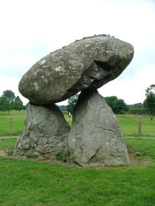
In Irish Celtic mythology , Cooley was the home of Donn Cuailnge , a brown bull, and the scene of the Táin Bó Cuailnge . A dolmen and a wedge tomb , both near Ballymascanlon, remind of this . The Court Tomb of rock Marshall is located in the Town Country rock Marshall, east of the R174 (road) near the junction with the R173.

