Copper Mountain (Colorado)
| Copper Mountain | |
|---|---|
 Mountains around Copper Mountain |
|
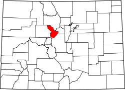
| Location in county and in Colorado | |
| Basic data | |
| Foundation : | 1977 |
| State : | United States |
| State : | Colorado |
| County : | Summit County, Colorado |
| Coordinates : | 39 ° 29 ′ N , 106 ° 12 ′ W |
| Time zone : | Central ( UTC − 6 / −5 ) |
| Residents : | 435 (as of 2019) |
| Population density : | 5.2 inhabitants per km 2 |
| Area : | 82.93 km 2 (approx. 32 mi 2 ) of which 82.93 km 2 (approx. 32 mi 2 ) is land |
| Height : | 2955 m |
| FIPS : | 08-17150 |
| GNIS ID : | 2583226 |
| Website : | www.coppercolorado.com |
Copper Mountain is a census-designated place in Colorado in Summit County . It is located 2955 meters above sea level and has a size of around 83 square kilometers .
Copper Mountain is located approximately 20 miles northeast of Leadville in the White River National Forest . Originally it was called Wheeler (named after a local judge and entrepreneur) and was also known as "Wheeler Station". In 1977 the name Copper Mountain was established by the Board on Geographic Names .
Copper Mountain is known for the mountain of the same name , on whose ski area winter sports competitions are held.
population
| Population development | |||
|---|---|---|---|
| Census | Residents | ± in% | |
| US Decennial Census | |||
See also
Web links
Wikivoyage: en: Copper Mountain - Travel Guide
Commons : Copper Mountain (Colorado) - Collection of images, videos, and audio files
Individual evidence
- ↑ a b Copper Mountain Census Designated Place in the Geographic Names Information System of the United States Geological Survey
- ^ Census of Population and Housing . Census.gov. Retrieved June 4, 2016.
