Cosmoledo
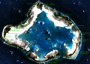
NASA image with island names
Waters
Indian Ocean
archipelago
Aldabra group
Geographical location
9 ° 42 ′ S , 47 ° 36 ′ E Coordinates: 9 ° 42 ′ S , 47 ° 36 ′ E -9.7083333333333 47.591666666667
Number of islands
16
Main island
Menai
Land area
5.2 km²
Lagoon area
145 km²
Residents
uninhabited
Nautical chart of Cosmoledo (1969)
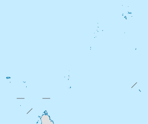
Cosmoledo is an atoll in the Indian Ocean . It belongs to the Aldabra group , which is one of the Outer Islands of the Seychelles . It is around 150 km east of the Aldabra Atoll. Astove Island is located about 38 kilometers south-southeast of Cosmoledo Atoll .
geography Cosmoledo is about 14.5 km long and about 11.5 km wide. The land area of the atoll is only 5.2 km², the area of the lagoon, however, about 145 km². The atoll consists of a total of 16 islets ( cays ) lying on the fringing reef , of which Menai in the west with 2.3 km² and Grande Île in the southeast with 1.6 km² are the largest.
fauna Cosmoledo is an important breeding area for sea birds . The largest colonies of all three species of booby found in the Seychelles can be found here . The red-footed booby colony is the largest in the Indian Ocean. There are also white frigate birds , ariel frigate birds and numerous species of terns, such as the sooty tern . Red-tailed tropical birds breed on the Grande Île , which in the Seychelles can only be found on Aldabra.
Islands The individual islands are listed in clockwise order starting with the northernmost:
north
West North Island
East North Island
east
Île du Trou
Goelette Island
Grand Polyte Island
Petit Polyte Island
Wizard Island (Île Grande) (with fishermen's huts) 1.6 km²
south
Pagoda Island
South Iceland
west
Île Moustique
île Baleine
Menai Island (formerly the main town, now abandoned) 2.3 km²
Île Chauve Souris
Ile Manaque
Observation Islet
Middle Islet
f1 OSM WikiMap
island
French
type
Coordinates Area ha
Coast
Length
Width
Height
0
cay
! 490.3288895547.5616675 09 ° 40 ′ 16.0 ″ S , 047 ° 33 ′ 42.0 ″ E -9.6711111111111 47.561666666667 0.03
0.08
0.03
0.01
0.00
1
cay
! 490.3333335547.5650005 09 ° 40 ′ 00.0 ″ S , 047 ° 33 ′ 54.0 ″ E -9.6666666666667 47.565 0.22
0.20
0.07
0.03
0.00
2
West North
Île du Nord iceland
! 490.3391675547.5722225 09 ° 39 ′ 39.0 ″ S , 047 ° 34 ′ 20.0 ″ E -9.6608333333333 47.572222222222 12.10
2.26
0.83
0.17
8.00
3
Central North
cay
! 490.3402785547.5794445 09 ° 39 ′ 35.0 ″ S , 047 ° 34 ′ 46.0 ″ E -9.6597222222222 47.579444444444 0.51
0.36
0.09
0.08
0.00
4th
East North
Île Nord-Est iceland
! 490.3366675547.5861115 09 ° 39 ′ 48.0 ″ S , 047 ° 35 ′ 10.0 ″ E -9.6633333333333 47.586111111111 6.30
1.40
0.37
0.45
0.00
5
cay
! 490.3316675547.5972225 09 ° 40 ′ 06.0 ″ S , 047 ° 35 ′ 50.0 ″ E -9.6683333333333 47.597222222222 0.47
0.38
0.09
0.09
0.00
6th
cay
! 490.3255565547.6100005 09 ° 40 ′ 28.0 ″ S , 047 ° 36 ′ 36.0 ″ E -9.6744444444444 47.61 0.42
0.29
0.05
0.06
0.00
7th
Trou
Île du Trou cay
! 490.3113895547.6291675 09 ° 41 ′ 19.0 ″ S , 047 ° 37 ′ 45.0 ″ E -9.6886111111111 47.629166666667 0.32
0.30
0.13
0.04
0.00
8th
North Goëlettes
cay
! 490.3005565547.6444445 09 ° 41 ′ 58.0 ″ S , 047 ° 38 ′ 40.0 ″ E -9.6994444444444 47.644444444444 2.50
0.95
0.37
0.15
0.00
9
South Goëlettes
cay
! 490.2980565547.6466675 09 ° 42 ′ 07.0 ″ S , 047 ° 38 ′ 48.0 ″ E -9.7019444444444 47.646666666667 0.29
0.33
0.15
0.03
0.00
10
Grande Polyte
iceland
! 490.2794445547.6572225 09 ° 43 '14.0 " S , 047 ° 39' 26.0" E -9.7205555555556 47.657222222222 27.70
4.00
0.21
1.64
0.00
11
Petite polytes
iceland
! 490.2705565547.6566675 09 ° 43 ′ 46.0 ″ S , 047 ° 39 ′ 24.0 ″ E -9.7294444444444 47.656666666667 1.68
0.59
0.20
0.10
0.00
12
Wizard Island
Grande Île iceland
! 490.2500005547.6500005 09 ° 45 ′ 00.0 ″ S , 047 ° 39 ′ 00.0 ″ E -9.75 47.65 160.40
9.60
3.6
0.56
17.00
13
pagoda
cay
! 490.2366675547.6066675 09 ° 45 ′ 48.0 ″ S , 047 ° 36 ′ 24.0 ″ E -9.7633333333333 47.606666666667 5.00
1.24
0.42
0.19
6.10
14th
South
Île du Sud-Ouest iceland
! 490.2297225547.5827785 09 ° 46 ′ 13.0 ″ S , 047 ° 34 ′ 58.0 ″ E -9.7702777777778 47.582777777778 42.30
6.5
0.25
2.92
6.00
15th
Mustiques
Île aux Moustiques iceland
! 490.2675005547.5097225 09 ° 43 ′ 57.0 ″ S , 047 ° 30 ′ 35.0 ″ E -9.7325 47.509722222222 1.90
0.66
0.24
0.11
0.00
16
Baleine
Île Baleine iceland
! 490.2755565547.5111115 09 ° 43 ′ 28.0 ″ S , 047 ° 30 ′ 40.0 ″ E -9.7244444444444 47.511111111111 1.05
0.45
0.10
0.14
0.00
17th
Menai
iceland
! 490.2833335547.5166675 09 ° 43 ′ 00.0 ″ S , 047 ° 31 ′ 00.0 ″ E -9.7166666666667 47.516666666667 246.80
10.05
1.10
3.18
12.20
18th
Bat
Île aux Chauve-Souris iceland
! 490.2847225547.5208335 09 ° 42 ′ 55.0 ″ S , 047 ° 31 ′ 15.0 ″ E -9.7152777777778 47.520833333333 0.12
0.14
0.03
0.03
0.00
19th
Macaques
Île aux Macaques iceland
! 490.2952785547.5308335 09 ° 42 '17.0 " S , 047 ° 31' 51.0" E -9.7047222222222 47.530833333333 0.55
0.33
0.06
0.10
0.00
20th
West Council
Île aux Rats iceland
! 490.2944445547.5272225 09 ° 42 ′ 20.0 ″ S , 047 ° 31 ′ 38.0 ″ E -9.7055555555556 47.527222222222 0.08
0.12
0.03
0.05
0.00
21st
East Council
Île aux Rats iceland
! 490.2947225547.5280565 09 ° 42 ′ 19.0 ″ S , 047 ° 31 ′ 41.0 ″ E -9.7052777777778 47.528055555556 0.11
0.15
0.04
0.02
0.00
22nd
La Croix
Ilot la Croix iceland
! 490.2952785547.5283335 09 ° 42 ′ 17.0 ″ S , 047 ° 31 ′ 42.0 ″ E -9.7047222222222 47.528333333333 0.22
0.22
0.05
0.06
0.00
23
Observation
iceland
! 490.2961115547.5358335 09 ° 42 '14.0 " S , 047 ° 32' 09.0" E -9.7038888888889 47.535833333333 0.46
0.33
0.05
0.10
0.00
24
Middle
Îlet milieu iceland
! 490.2972225547.5372225 09 ° 42 '10.0 " S , 047 ° 32' 14.0" E -9.7027777777778 47.537222222222 0.56
0.50
0.20
0.05
0.00
25th
Little Astove
cay
! 490.3036115547.5500005 09 ° 41 ′ 47.0 ″ S , 047 ° 33 ′ 00.0 ″ E -9.6963888888889 47.55 0.22
0.19
0.06
0.04
0.00
Cosmoledo Atoll atoll
! 490.2833335547.5833335 09 ° 43 ′ 00.0 ″ S , 047 ° 35 ′ 00.0 ″ E -9.7166666666667 47.583333333333 513.00
10
Individual evidence
↑ a b 2010 Sailing directions ( Memento Internet Archive
↑ a b Info on the islands ( Memento of original Internet Archive Info: The archive link was inserted automatically and has not yet been checked. Please check the original and archive link according to the instructions and then remove this notice. @1 @ 2 Template: Webachiv / IABot / www.virtualseychelles.sc
<img src="https://de.wikipedia.org//de.wikipedia.org/wiki/Special:CentralAutoLogin/start?type=1x1" alt="" title="" width="1" height="1" style="border: none; position: absolute;">
![]() Map with all coordinates: OSM | WikiMap
Map with all coordinates: OSM | WikiMap


