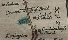
Counter's Creek

The Counter's Creek ( Chelsea Creek in its lower reaches) is a watercourse in London , England . It arises on Kensal Green and flows south to its confluence with the Thames . Today it runs largely underground. Its last section still visible on the surface is in the area of Chelsea Creek just before its mouth.
course

Counter's Creek was formed on Kensal Green from the confluence of two small tributaries that met west of Ladbroke Grove and near Latimer Road just south of St Quintin Avenue . It flowed through Kensal Green Cemetery , Little Wormwood Scrubs in North Kensington and Shepherd's Bush on one side and Olympia in Kensington on the other. Then it flowed past Earls Court on one side and through West Brompton on the other. As a remnant, there is still an overflow drainage channel next to platform 4 (towards Olympia) of West Brompton underground station . Counter's Creek passes Brompton Cemetery and the Chelsea FC facility at Stamford Bridge . The former Lots Road Power Station is where the watercourse flows into the Thames . The estuary affected by the tides is shown as Chelsea Creek on modern maps .
history
The upper reaches of the watercourse have been referred to as Billingswell Ditch , Pools Creek, and Counters Creek . In the Middle Ages it was known as the Billingwell Dyche , derived from Billing's Spring or Billing's Stream . It formed the border between the parishes of Kensington and Fulham. In the 18th century, the name Counter's Creek, believed to come from the Counter's Bridge that crossed the watercourse at the western end of Kensington High Street , became common. This was first recorded in the 14th century as Countessesbrugge and may have been named after Maud Ufford , who held the manor house of Kensington after the Norman conquest . Stamford Bridge is understood as a modification of Samfordesbrigge and means the bridge at the sandy ford where the Fulham Road crosses the watercourse. From 1824 to 1828 the lower course was transferred to the Kensington Canal . This was largely moved underground by the Bristol Birmingham & Thames Junction Railway in the 1830s to accommodate the West London Line from 1859 to 1863 . Only the lower reaches remained as a watercourse in order to be able to deliver coal for the Sands End gasworks and later the Lots Road Power Station .
The watercourse was above ground to the west of Little Wormwood Scrubs as shown on pre-1930 maps. At that time, surface water drains were set up, which were fed to the sewers . Its course has been used since the 19th century with the advent of toilet flushing to set up a mixed system that led into the Thames.
See also
Web links
- Counter's Creek: In Search Of London's Unknown River. on londonist.com
Individual evidence
- ^ Nicholas Barton: The Lost Rivers of London. 1962, ISBN 0-948667-15-X .
- ^ Map ( memento of July 28, 2011 in the Internet Archive ) from Nicholas Barton's book Lost London Rivers.
- ↑ list.english-heritage.org.uk ( memento of the original from April 24, 2012 in the Internet Archive ) Info: The archive link was inserted automatically and has not yet been checked. Please check the original and archive link according to the instructions and then remove this notice. Ordnance Survey Map from English Heritage .
- ↑ Open Street Map
- ^ A b F HW Sheppard: Stamford Bridge and the Billings area. In: Survey of London. Volume 41, Brompton, London 1983, pp. 241-245. British History Online. Retrieved April 21, 2016.
- ^ Henry Rodolph de Salis, Bradshaw's canals and navigable rivers of England and Wales: A reprint of a handbook of inland navigation for manufacturers, merchants, traders, and others. AM Kelley, New York 1969, p. 436. ( books.google.de )
- ^ A b Edward Walford: The old court suburbs: Kensington. In: Old and New London. Volume 5. London 1878, pp. 117-137. British History Online. Retrieved April 21, 2016.
- ↑ JEB Gover, Allen Mawer, FM Stenton: The Place-Names of Middlesex. 1942.
- ^ Charles James Feret: Fulham Old and New. Vol. 2, 1900.
- ^ Hermione Hobhouse: The Kensington Canal, railways and related developments. In: Survey of London. Volume 42: Kensington Square To Earl's Court. London, 1986, pp. 322-338. British History Online. Retrieved April 21, 2016.
Coordinates: 51 ° 28 ′ 40 " N , 0 ° 10 ′ 47" W.