
Hay land
| Hay land | ||
|---|---|---|
|
||
| region | Normandy | |
| Department | Calvados | |
| Arrondissement | Lisieux | |
| Canton | Cabourg | |
| Community association | Normandy-Cabourg-Pays d'Auge | |
| Coordinates | 49 ° 17 ′ N , 0 ° 0 ′ W | |
| height | 25-148 m | |
| surface | 3.02 km 2 | |
| Residents | 97 (January 1, 2017) | |
| Population density | 32 inhabitants / km 2 | |
| Post Code | 14430 | |
| INSEE code | 14329 | |
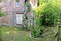
 Notre-Dame church |
||

Heuland is a French commune with a population of 97 (as at 1st January 2017) in the department of Calvados in the region Normandy (2015: Basse-Normandie ). The municipality belongs to the Arrondissement Lisieux and the municipality association Normandie-Cabourg-Pays d'Auge, founded in 2016 .
geography
Heuland is located in the hinterland of the Côte Fleurie of the English Channel in the Pays d'Auge landscape on the prime meridian , about 25 kilometers northeast of Caen . The 3 km² municipal area consists of several hamlets and individual farms and has no historical core. The Notre-Dame church is isolated, the Mairie in the La Croix d'Heuland district on the northern border of the municipality. Other districts are La Cour Beley, Cour Vattier, Manoir de Grainville, La Cour Langlois, Les Fontaines, Cour Gentil, La Cour du Manoir, Ferme de la Bruyère, Les Jardins Charles, Hameau du Bosq, Cour de la Maison, La Cour Mouchelet and Geymard . Heuland is surrounded by the neighboring communities of Saint-Vaast-en-Auge in the north, Branville in the northeast, Danestal in the southeast, Cresseveuille in the south, Angerville in the southwest and Douville-en-Auge in the west. The southern border of the municipality of Heuland is formed by the Ancre river , a tributary of the Dives .
Population development
| year | 1806 | 1962 | 1968 | 1975 | 1982 | 1990 | 1999 | 2008 | 2016 |
|---|---|---|---|---|---|---|---|---|---|
| Residents | 260 | 100 | 92 | 79 | 61 | 54 | 71 | 89 | 88 |
| Sources: Cassini and INSEE | |||||||||
Attractions
- Notre-Dame church
- Water tower
- Lavoir (wash house)
- Menhir
- Monumental cross next to the town hall ( Heuland croix )
- Monumental cross from the 16th century on the border with the municipality of Branville ( Croix Rollon ), Monument historique

Wash house

Heuland croix
Menhir built into a corner of a house

Croix Rollon


Economy and Infrastructure
Four farms are located in the municipality of Heuland (horse, sheep, goat and cattle breeding).
In Heuland, the main road D 45 branches off from the main road D 27 ( Caen - Touques ) to Lisieux . The A13 car route runs immediately south of the municipality .
literature
- Le Patrimoine des Communes du Calvados. Volume 1, Flohic Editions, Paris 2001, ISBN 2-84234-111-2 , pp. 731-732.
supporting documents
- ↑ Heuland on cassini.ehess.fr (French)
- ↑ Heuland on INSEE
- ^ Monumental cross in the Base Mérimée of the Ministry of Culture. Retrieved April 21, 2016 (French).
- ↑ Farms on annuaire-mairie.fr (French)